.gif)
A Study of the Park and Recreation Problem of the United States
MENU
Aspects of Recreational Planning
Present Public Outdoor Recreational Facilities
![]() A Park and Recreational Land Plan
A Park and Recreational Land Plan
|
A Study of the Park and Recreation Problem of the United States
|

|
A Park and Recreational Land Plan for the United States (continued)
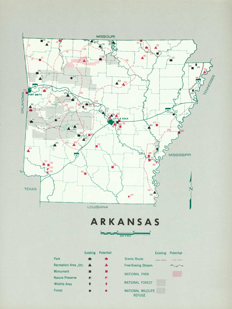
ARKANSAS
THE POPULATION was 79.4 percent rural in 1930 and rather evenly distributed, with the major concentration occurring in the Arkansas River Valley between Little Rock and Pine Bluff. One-fourth of the population is Negro and they comprise the majority of the inhabitants in the lowland counties along the Mississippi and White Rivers.
The Ozark and Ouachita Mountains in the northwest half of the State divided by the scenic Arkansas River Valley form the major recreation section of the State. The beautiful wooded mountains, fine streams and large springs, combined with a favorable climate, attract vacationists from within and without the State.
The Arkansas State Park Board has made considerable progress in the development of a State park system. However, a strip of territory running from north to south through the center of the State is still unprovided with recreational areas. This territory includes the State's major population center of Little Rock and 16 smaller urban communities.
There is need for certain additional State parks and for local day-use areas for the white and Negro rural population.
Consideration should be given preservation and improvement of scenic recreational travel routes through the State and the provision of wayside areas for the enjoyment of tourists.
Congress has authorized the construction of seven large reservoirs in Arkansas and the State should consider the planning and development of recreational areas adjacent to those reservoirs.
(click on image for an enlargement in a new window)
| FEDERAL | ||
| National park: | Existing acreage |
Proposed additions |
| 11. Hot Springs | 1,006.4 | |
| National forests: | ||
| 7. Ozark | 787,155 | |
| 10. Ouachita | 1,237,155 | |
| Total | 12,024,310 | |
| National wildlife areas: | ||
| 25. White River Migratory Waterfowl Refuge | 96,311 | |
| 29. Big Lake Bird Refuge | 9,379 | |
| Total | 105,690 | |
| Soil Conservation Service land development projects:2 | ||
| 2. Boston Mountain | 10 | |
| 4. Northwest Arkansas | 908 | |
| 5. Eureka Springs | 400 | |
| 22. De Valls Bluff | 10 | |
| 26. Marianna-Helena | 2,500 | |
| Total | 3,828 | |
| Proposed national parkway: | ||
| 23. Mississippi River | ||
| STATE | ||
| State parks: | ||
| 3. Devils Den | 4,230 | |
| 8. Mount Nebo | 3,375 | |
| 9. Petit Jean | 2,999 | |
| 12. Lake Catherine | 2,048 | |
| 18. Watson Negro | 100 | |
| 21. Buffalo River | 1,735 | |
| 28. Crowley's Ridge | 273 | |
| Total | 14,850 | 14,760 |
| State monuments: | ||
| 17. Donaghey | 20 | |
| 24. Arkansas Post | 61.6 | |
| Total | 81.6 | |
| State wildlife area: | ||
| 27. Craighead County | 3,420 | |
| LOCAL | ||
| County parks: | ||
| 1. Lake Lu Emma, Crawford County | ||
| 15. Poison Springs, Ouachita County | ||
| 16. Calion Lake, Union County | ||
| 20. Summit, Marion County | ||
| 30. Mississippi County Park | ||
| Municipal parks: | ||
| 13. Hope (1 area) | 35 | |
| 14. Texarkana (1 area) | 175 | |
| 19. Little Rock (2 areas) | 720 | |
| Total | 930 | |
1 Area under Federal administration June 1938.
2 Acreages given are portions of large projects being developed for recreation, March 1939.
NEXT >>>
 Top
Top
Last Modified: Mon, Aug 9 2004 10:00:00 pm PDT
http://www.cr.nps.gov/history/online_books/park_recreation/arkansas.htm
![]()