.gif)
A Study of the Park and Recreation Problem of the United States
MENU
Aspects of Recreational Planning
Present Public Outdoor Recreational Facilities
![]() A Park and Recreational Land Plan
A Park and Recreational Land Plan
|
A Study of the Park and Recreation Problem of the United States
|

|
A Park and Recreational Land Plan for the United States (continued)
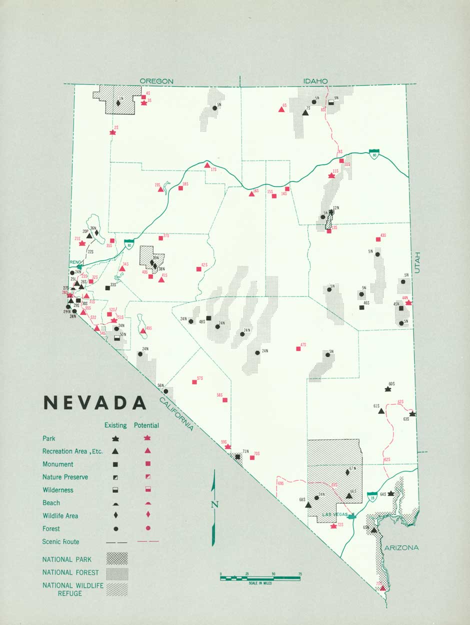
NEVADA
ABOUT ONE-THIRD of the people live within a 30-mile radius of Reno and the remainder are well scattered throughout the State. There are only six communities having a population of over 3,000 inhabitants. The out-of-State motorists exceed by several times the resident population.
With the exception of a relatively small area along its rivers, Nevada is desert, mountainous, rocky, and dry. Eighty-eight percent of the land is in public ownership and the remainder is divided about equally between private holdings and the Southern Pacific Railroad.
The United States Forest Service maintains a number of picnic and camp grounds in its six national forests. The National Park Service administers Boulder Dam National Recreational Area and Lehman Caves National Monument. Under State ownership and administration are 32 recreational areas. Reno and Ely provide municipal parks. Privately owned or operated recreational ranches are of major importance and provide extensive facilities for traveling vacationists.
The State should continue to acquire and administer the more important and interesting scenic, historic, archeologic, and geologic sites; develop a coordinate plan in conjunction with the various public and private interests to provide adequate overnight housing and camping accommodations, waysides, and picnic facilities along the transcontinental highways; endeavor to prevent the drying up of Pyramid Lake by refraining from taking too much water for irrigation purposes; and cooperatively work out a program of acquisition and development of public recreation facilities in the Lake Tahoe region.
(click on image for an enlargement in a new window)
| FEDERAL | ||
| National monuments: | ||
| 34. Death Valley | 115,200 | |
| 53. Lehman Cave | 640 | |
| Total | 115,840 | |
| National recreational area: | ||
| 64. Boulder Dam | 556,795 | |
| National forests: | ||
| 1. Mono | 466,012 | |
| 4. Eldorado | 400 | |
| 14. Tahoe | 16,373 | |
| 31. Inyo | 60,576 | |
| 39. Toiyabe | 2,152,313 | |
| 44. Humboldt | 1,059,865 | |
| 52. Nevada | 1,232,623 | |
| Total | 14,988,162 | |
| National wildlife areas: | ||
| 19. Anaho Island Bird Refuge | 247.7 | |
| 20. Winnemucca Migratory Bird Refuge | 11,915 | |
| 21. Charles Sheldon Antelope Refuge | 34,235 | |
| 22. Charles Sheldon Antelope Range | 542,509.2 | |
| 27. Fallon Wildlife Refuge | 17,901.2 | |
| 49. Ruby Lake Migratory Waterfowl Refuge | 28,045.2 | |
| 54. Railroad Valley Migratory Bird Refuge | 135,184.3 | |
| 59. Desert Game Range | 2,022,000 | |
| 63. Boulder Canyon Wildlife Refuge | 2346,443 | |
| Total | 3,138,480.6 | |
| STATE | ||
| State parks: | ||
| 56. Cathedral Gorge | 1,578.7 | |
| 57. Kershaw Canyon-Ryan | 240 | |
| 58. Beaver Dam | 718.6 | |
| 61. Valley of Fire State Park-Overton Museum | 8,756 | |
| Total | 11,293.3 | |
| Potential State parks: | ||
| 6. Hudson Hot Springs | 10 | |
| 11. Mineral Hot Springs | 25 | |
| 30. Walker Lake | 2,295 | |
| 45. Mineral Hot Springs | 25 | |
| 47. Ruby Mountain | 2,000 | |
| 48. Ruby Lakes | 160 | |
| 51. Fish Creek Ranch | 160 | |
| 60. Hidden Forest | 5,760 | |
| 62. Virgin Mountain Range | 100 | |
| 68. Las Vegas | 640 | |
| Total | 11,175 | |
| State monuments: | ||
| 10. Carson City Prison Fossil Beds | 7 | |
| 12. Fort Churchill | 200 | |
| Total | 207 | |
| Potential State monuments: | ||
| 3. Hudson Fossil Fields | 4,340 | |
| 5. Genoa, First House | 1 | |
| 7. Petrified Sequoias | 320 | |
| 13. Virginia City | .5 | |
| 18. Petroglyphs | 120 | |
| 23. Opal Fields | 300 | |
| 25. Star City | 640 | |
| 26. Lovelock Caves | 12,800 | |
| 28. Soda Lake | 1,000 | |
| 29. Petroglyphs—Mountain of Hieroglyphs | 5 | |
| 32. Deposit of Prehistoric Bones | 160 | |
| 33. Petrified Forest | 1,000 | |
| 35. Bullfrog,Ryolite | 160 | |
| 36. Chloride Cliffs | 640 | |
| 37. O'Brien's Petrified Forest | 50 | |
| 38. Northumberland Caves | 320 | |
| 40. Diana's Punch Bowl | 50 | |
| 42. Beowane Hot Springs | 25 | |
| 55. Hot Creek Crater | 120 | |
| 66. Gypsum Cave | 1,000 | |
| 67. Fort Vegas | 6 | |
| 69. Potosi Mines | 640 | |
| Total | 23,697.5 | |
| State waysides: | ||
| 8. Cave Rock | 2 | |
| 9. Clear Creek Picnic Grounds | 10 | |
| 16. Geiger Grade Lookout | 3 | |
| 17. Court of Antiquity | 2 | |
| Total | 17 | |
| Potential State waysides: | ||
| 41. Stokes Castle | 10 | |
| State Wildlife areas: | ||
| 46. Nevada School of Industry Game Refuge | 600 | |
| LOCAL | ||
| County parks: | ||
| 15. Washoe | 480 | |
| Potential County parks: | ||
| 2. Lyon County Area | 16 | |
1 Area under Federal administration June 1938.
2 This acreage included in acreage of Boulder Dam National Recreational Area except for 7,000 acres.
NEXT >>>
 Top
Top
Last Modified: Mon, Aug 9 2004 10:00:00 pm PDT
http://www.cr.nps.gov/history/online_books/park_recreation/nevada.htm
![]()