.gif)
A Study of the Park and Recreation Problem of the United States
MENU
Aspects of Recreational Planning
Present Public Outdoor Recreational Facilities
![]() A Park and Recreational Land Plan
A Park and Recreational Land Plan
|
A Study of the Park and Recreation Problem of the United States
|

|
A Park and Recreational Land Plan for the United States (continued)
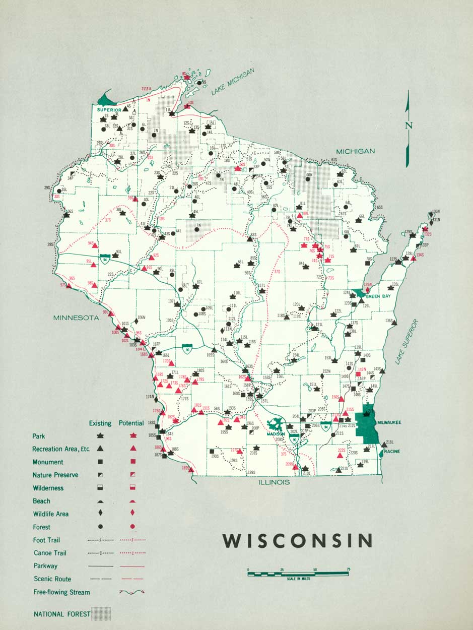
WISCONSIN
ONE-THIRD OF THE POPULATION in 1930 was concentrated in the industrial section in the southeastern part of the State. Variations in density range from 3,086 persons per square mile in Milwaukee County to 8 persons per square mile in Sawyer County in northwest Wisconsin. Only one-third of the State's inhabitants live on farms. The northern half of the State has a generally decreasing permanent population but an increasing summer or vacation population. Wisconsin shares with Minnesota and Michigan in popularity as the vacation region of the great Middle West. Its many lakes and streams, vast forests, good roads, beautiful farmland, and neat cities and villages constitute recreation resources of great value.
The recreation requirements are complicated by a variety of interests to be served, the great urban population of southeastern Wisconsin and northeastern Illinois, the vacationists from many States and the rural residents of Wisconsin. Federal, State, and local agencies have made good progress toward providing public lands for recreation, but there is still much to be done to meet the great demand in this State.
Additional areas should be included in the State park system, State forests expanded, a system of parkways developed along the major streams and Lake Michigan, and waysides along the highways. Existing county, metropolitan and municipal park systems should be enlarged and new ones created.
(click on image for an enlargement in a new window)
| FEDERAL | ||
| National forests: | ||
| 31. Chequamegon | 784,077 | |
| 96. Nicolet | 536,336 | |
| Total | 11,320,413 | |
| National wildlife areas: | ||
| 15. Upper Mississippi Waterfowl Refuge | 54,502 | |
| 17. Trempealeau Migratory Waterfowl Refuge | 706.9 | |
| 58. Necedah | 40,500 | |
| 128. Long Tail Migratory Waterfowl Refuge | 103.1 | |
| 156. Gravel Island Reservation | 27 | |
| 157. Green Bay Reservation | 1.9 | |
| Total | 95,840.9 | |
| Soil Conservation Service land development projects: | ||
| 52. Camp McCoy Picnic Area | 28 | |
| 53. Mill Bluff Roadside Park | 255.5 | |
| 55. Castle Mound Picnic Area | 210 | |
| Total | 73.5 | |
| Proposed national parkway: | ||
| 43. Mississippi River | ||
| STATE | ||
| State parks: | ||
| 4. Interstate | 581 | 230 |
| 9. Pattison | 1,140 | 400 |
| 40. Perrot | 936 | 329 |
| 45. Wyalusing | 1,671 | 129 |
| 64. Copper Falls | 1,200 | 360 |
| 75. Devils Lake | 1,313 | 1,068 |
| 91. Rib Mountain | 324 | 1,520 |
| 145. Terry Andrae | 167 | 908 |
| 153. Potawatomi | 1,046 | 608 |
| 155. Peninsula | 3,388 | 302 |
| Total | 11,766 | 5,854 |
| Recommended State parks: | ||
| 1. Lake Pepin | 1,000 | |
| 7. St. Croix River | 12,000 | |
| 28. Apostle Islands | ||
| 51. Kickapoo Valley and Wildcat Mountain | ||
| 77. Blue Mounds | 2,000 | |
| 88. Dells of Wisconsin River | 2,500 | |
| 104. Waupaca Lakes | 1,000 | |
| 109. Kettle Moraine | (3) | |
| 132. Lake Winnebago | 1,000 | |
| 139. Kenosha Lake Shore | 1,500 | |
| Total | 21,000 | |
| State forests: | ||
| 11. Brule River | 3,991 | |
| 32. Flambeau River | 2,961 | 47,039 |
| 71. Council Grounds | 277 | |
| 93. American Legion | 28,856 | |
| 94. Northern Highland | 133,482 | |
| 123. Athelstone | 3,500 | |
| 134. Kettle Moraine | 2,947 | 30,553 |
| 150. Point Beach | 715 | 985 |
| Total | 176,729 | 78,577 |
| State monuments: | ||
| 46. Nelson Dewey | 720 | |
| 48. First Capitol | 2 | |
| 76. Tower Hill | 67 | 56 |
| 113. Cushing Memorial | 9.3 | 4 |
| Total | 798.3 | 60 |
| Recommended State monuments: | ||
| 2. Fort St. Antoine | ||
| 29. Cadotte and Warren Trading Post | ||
| 44. Fort Crawford | ||
| 47. Early Lead Mines | ||
| 57. Castellated Buttes and Mesas | ||
| 65. Potato River | ||
| 79. Sugar Creek Valley | ||
| 86. Fort Winnebago | ||
| 87. John Muir | ||
| 107. Aztalan | ||
| 108. Scuppernong Marsh | ||
| 112. Dewey Mounds | ||
| 118. Winnebago Indian Village | ||
| 142. Cedarbug Bog | ||
| 149. Interglacial Forest Bed | ||
| State wildlife area: | ||
| 114. Horicon Marsh—State Refuge | 1,000 | |
| State roadside parks: | ||
| 16. Merrick | 123 | 88 |
| 21. Brunet Island | 179 | |
| 25. Ojibwa | 125 | 10 |
| 74. Rocky Arbor | 227.6 | |
| 78. New Glarus | 43 | 257 |
| Total | 697.6 | 355 |
| Recommended State parkways: | ||
| 3. St. Croix River | ||
| 49. Wisconsin River | ||
| 85. Connecting Parkway | ||
| 105. Fox River (north) | ||
| 106. Rock River | ||
| 111. Fox River (south) | ||
| 120. Wolf River | ||
| 133. Milwaukee River | ||
| 143. Lake Michigan Shore | ||
| Recommended State trailways: | ||
| 13. Red Cedar River | ||
| 19. Chippewa River | ||
| 26. Flambeau River | ||
| 37. Black River | ||
| 50. Kickapoo River | ||
| LOCAL | ||
| County parks: | ||
| 10. Douglas | 1,355 | |
| 14. Dunn | 6 | |
| 18. Eau Claire | 4,190 | |
| 20. Chippewa | 5 | |
| 22. Rusk | 80 | |
| 30. Bayfield | 83 | |
| 35. Clark | 6 | |
| 39. Jackson | 120 | |
| 41. La Crosse | 46 | |
| 42. Vernon | 168 | |
| 60. Wood | 566 | |
| 61. Taylor | 40 | |
| 66. Iron | 100 | |
| 72. Marathon | 1,829 | |
| 84. Dane | 145 | |
| 89. Portage | 40 | |
| 101. Langlade | 145 | |
| 102. Shawano | 35 | |
| 103. Waupaca | 64 | |
| 115. Fond du Lac | 110 | |
| 119. Outagamie | 320 | |
| 121. Oconto | 52 | |
| 126. Marinette | 54 | |
| 131. Calumet | 175 | |
| 136. Milwaukee | 2,784 | |
| 137. Racine | 106 | |
| 138. Kenosha | 537 | |
| 144. Ozaukee | 42 | |
| 151. Brown | 130 | |
| 152. Kewaunee | 100 | |
| 154. Door | 72 | |
| Total | 13,505 | |
| Recommended county parks: | ||
| 110. Walworth | ||
| 117. Winnebago | ||
| 146. Sheboygan | ||
| 147. Manitowoc | ||
| County forests: | ||
| 5. Polk | 7,930.96 | |
| 6. Burnett | 76,324.91 | |
| 8. Douglas | 205,326.35 | |
| 12. Washburn | 95,819.75 | |
| 23. Rusk | 75,814.33 | |
| 24. Sawyer | 69,119.35 | |
| 27. Bayfield | 124,667.73 | |
| 33. Price | 55,915.20 | |
| 34. Taylor | 6,213.92 | |
| 36. Eau Claire | 24,076.44 | |
| 38. Clark | 115,440.79 | |
| 54. Monroe | 5,464.37 | |
| 56. Jackson | 96,504 | |
| 59. Wood | 24,076.44 | |
| 63. Ashland | 22,862.63 | |
| 67. Iron | 121,708.31 | |
| 69. Oneida | 137,641.64 | |
| 70. Lincoln | 73,627.35 | |
| 73. Juneau | 7,374.95 | |
| 95. Vilas | 33,992.12 | |
| 98. Forest | 10,146.16 | |
| 99. Langlade | 89,637.27 | |
| 122. Oconto | 27,470.14 | |
| 124. Marinette | 199,043.18 | |
| 125. Florence | 31,724.14 | |
| Total | 1,737,922.43 | |
| Municipal parks: 4 | ||
| 80. Beloit (2 areas) | 105.8 | |
| 81. Jamesville (2 areas) | 219 | |
| 82. Fort Atkinson (1 area) | 13.5 | |
| 83. Madison (1 area) | 23 | |
| 90. Stevens Point (1 area) | 104 | |
| 92. Tomahawk (1 area) | 50 | |
| 116. Oshkosh (1 area) | 200 | |
| 127. Oconto (1 area) | 20 | |
| 129. Green Bay (1 area) | 4.9 | |
| 130. Menasha (1 area) | .8 | |
| 140. Kenosha (1 area) | 49 | |
| 141. Racine (2 areas) | 352 | |
| 148. Manitowac (1 area) | 80 | |
| Total | 1,222 | |
| Recommended metropolitan park system: | ||
| 135. Milwaukee | ||
1 Area under Federal administration June 1938.
2 Recreational areas developed as part of larger project.
3 Included in total acreage of Kettle Moraine State Forest.
4 From Municipal and County Parks in U.S. 1935. Municipal parks outside city limits.
NEXT >>>
 Top
Top
Last Modified: Mon, Aug 9 2004 10:00:00 pm PDT
http://www.cr.nps.gov/history/online_books/park_recreation/wisconsin.htm
![]()