|
| ||||||||||
| Intro | Author | Subject | Volume | Volume/Title | NPS | |||||
|
Volume 3 - No. 3 |
July, 1941 |
|
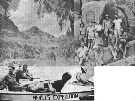
DESCENT OF THE CANYONS By Norman D. Nevills.
Green River, Wyoming, 10 A.M., June 20, 1940 - There were eight of us, including two women, and we breathed sighs of pleasure and anticipation as I gave the signal to push the three rowboats into mid-stream. Nearly 1,200 miles of canyons and rapids were ahead of us - scenery to hold the most critical, spellbound. By use of a map, we hoped to find a great natural bridge that would rival or possibly surpass in size the world's largest known natural stone arch, the Rainbow Bridge, 309 feet high, in Rainbow Bridge National Monument, Utah. Major John W. Powell, early explorer of the Green and Colorado Rivers, left this same place just 71 years before us. This would be the first time that women had attempted to follow the course set by the intrepid Major in 1869. The 200 or so persons in the interested and friendly town of Green River were rapidly lost to view. Our adventure was started. The Colorado River, as we know it in the Grand Canyon, has its source in the high mountains of Colorado and Wyoming. Near the upper reaches of the proposed Escalante National Recreational Area in Utah, the main Colorado River has its inception at the Junction - the confluence of the Upper Colorado and the Green Rivers. Tradition and interest are established in the canyons formed by the Green River to the Junction, and a more remarkable and colorful series of canyons would be hard to find. The first few days of our trip saw us in the relatively open country south of Green River, Wyoming. We became used to our boats and their handling. The design of these boats was evolved from a number of years' study of different types of craft used on my trips on the San Juan River. These latest models were 16 feet long, 6 feet wide, one-third open, and contained 7 water-tight compartments. They were well adapted for rough water. My lead, or pilot boat, the WEN, was also my lead boat in 1938 when I went from Green River, Utah, to Boulder Dam during high water. Aside from design, an innovation in boat construction was the use of a special 5-ply marine plywood. This material, with its amazing strength and durability, assured us of almost indestructible crafts. About 68 miles below Green River, Wyoming, we entered the portals of Flaming Gorge, Colorado, in the Dinosaur National Monument. This was the first of the sixteen canyons we would pass through to Boulder Dam. Sundown lights accentuated the red cast of the deep canyon, and it was a real flaming gorge in which we made Camp No. 3. Our large load capacity simplified the camping problems. Two compact nested cooking sets were ample for all meals. We used canned goods almost without exception, and the menus were prepared in advance of our starting, by my wife, Doris. Her unfailing good nature and cheerfulness in trying situations throughout the trip contributed much to our success. Her past river experience proved in good stead in preparing the menus. This system conserved supplies, as we at all time knew exactly what to open. Doris prepared all the meals, assisted by the other woman voyager, Miss Mildred Baker of Buffalo, New York.
The day following our entrance into Flaming Gorge, we passed through Horseshoe and Kingfisher Canyons, on down into our first real rapids, in Red Canyon. It was a welcome change to be in the depths of these beautiful canyons; our progress was faster, the water was more interesting, and the scenery was of incomparable beauty. Early each morning, Doris would write a resume of our previous day's events and send the message to the Salt Lake City newspapers, by carrier pigeon. It was a thrilling sight to see the birds swoop up and strike an unerring course. On a few occasions film was sent out this way, and a few hours later the pictures were printed in the newspapers. Each succeeding mile brought us into deeper canyons, and into rapids that increased in their furry. Our passage through Lodore Canyon was marked by a near accident when one of the boats was tossed up on a rock in Disaster Falls. Triplet Falls and Hell's Half Mile were run successfully, and that saw us through the steepest part of the Green River. There is a drop of 25 feet in Hell's Half Mile. Just above Jensen, Utah, we landed the boats and walked one mile to see the dinosaur quarry and the museum, in Dinosaur National Monument. Part of the monument is in Utah, and part in Colorado. Nowhere else in the world have dinosaur remains been found in such abundance and concentration as in this quarry. Day by day the miles were put behind us. There was never a tiresome moment; always something new and different to interest us. Time and distance passed quickly, and almost before we could realize it we were down to Green River, Utah, one-third of our journey completed. Here we stayed a couple of days to take on more supplies, get out letters, and visit with friends and relatives who came to see us. Here B. W. Deason, Salt Lake City assayer, left us, to rejoin the party at Bright Angel, in Grand Canyon National Park. His place was taken by Miss Anne Rosner, Chicago school toacher. Also to join the party was Barry Goldwater, Phoenix merchant, and Arizona historian. For the next 117-1/2 miles through the Labyrinth and Stillwater Canyons to the junction with the Colorado River, we would have smooth water unbroken by any rapids. For this stretch we used outboard motors to relieve the monotony and tiresomeness of rowing. And then would come Cataract Canyon, the "Graveyard of the Colorado." The rapids to be encountered there would pale to insignificance the rapids of the Green River. We all felt undaunted, as our equipment and personnel were believed to be adequate for the task. Handling my other two boats, the JOAN, named after our 3-year-old daughter; and the MEXICAN HAT II, were two men whom I had trained on previous trips. Dr. Hugh Cutler, botanist of the Missouri Botanical Gardens, handled the Mexican Hat II, and he also spent all possible time in gathering flora and making a study of plant life. Dell Reid, a prospector, and member of my 1938 expedition, guided the Joan. Our photographer was C. W. Larabee, of Kansas, genial and excellent all round man. Larabee's pictures were supplemented by the excellent photography of Barry Goldwater, known for his photographs of Arizona. Mining Engineer J. S. Southworth of California, rounded out our crew. The unexpected abilities of Mr. Southworth were a real asset. r On July 10th, we were proceeding down the river. The water was low, and sandbars were troublesome. Overnight camp was made at a geyser that was developed during oil prospecting operations. Passing the San Rafael River we entered Labyrinth Canyon, and crossed the northernmost boundary of the proposed Escalante National Recreational Area. We were here in the lovely orange tinted sandstones, and abounding on each side were monuments of many types and descriptions. Major Powell called this the "Land of Standing Rocks." I hope that this little known and exceedingly beautiful section will soon be made more accessible so that thousands of people can see and enjoy its weird and magnificent grandeur. The canyon rapidly gets deeper; soon we were between two almost polished walls, and only occasional views of the tops were possible. Each of the many interesting side canyons, with cliff ruins and surface sites of prehistoric dwellers, was a trip and adventure in itself. The miles passed rapidly amidst all this charming and interesting display. Nature must have been in an extra benevolent mood for spreading beauty, when moulding this canyon. July 14th - Junction of the Green and Colorado Rivers! The confluence of the Green and Upper Colorado forms a mighty and impressive river. The formation here gives way to immensely high cragbound cliffs that would be formidable obstacles to anyone trying to gain access to the rim. Bishop and Wayne McConkie of Moab, were here to meet us, and to see us run the first little rapids of Cataract Canyon. We had planned to stay here at least half a day, but impatience to start the task of navigating Cataract Canyon was too much, and after hurriedly writing letters for the McConkies to take out, we embarked again. Cataract Canyon is only 41 miles long, but it is filled with innumerable rapids, many of them very dangerous unless every precaution is observed. This section, owing to the number of fatalities occurring to earlier parties, was well named the "Graveyard of the Colorado." Our good fortune held through here, and our passage was marked with but one serious mishap. In rapid 24, Dell Reed, boatman involved in the Disaster Falls experience, this time had a close call when he got off the channel. It took us several hours of hard work to extricate Reed and the Joan, and we were glad to crawl into our sleeping bags that night. There are mountain sheep in this area, but very little else except rabbits and rattlesnakes. Towards the foot of Cataract Canyon is the lateral tributary, Dark Canyon. Fabulous tales are told of great prehistoric ruins in this canyon, so we spent several days here in an effort to penetrate up from the river as far as possible. Much work resulted in only getting 7 or 8 miles into the canyon. Waterfalls are a great problem, and I am convinced that the Cliffdwellers never used the lower end of the canyon to reach the river, as there are no pictographs or other indications. It would be worthwhile entering from the head and working down, as the upper reaches were no doubt occupied in the past. Mille Crag Bend marked the terminus of Cataract Canyon, and now for the next 184-1/2 miles of Narrow and Glen Canyons we would relax on the relatively smooth water, and give ourselves up to the fascinating and charming beauty of Glen Canyon. The rest would prove welcome in preparation for the rough, heavy rapids of Marble and Grand Canyons. To this point every rapid had been run, but I doubted if this record would maintain, as the constantly lowering river was making for extremely rocky channels. Upon entering Narrow Canyon we again put on our outboard motors, and the 9 miles were quickly put behind. We were impatient for a sight of the Dirty Devil, or Fremont River, marking the head of Glen Canyon. In 1869 Major Powell, upon reaching this point, called to Jack Sumner: "Is it good water, Jack?" "No, she's a dirty devil," replied Sumner. And truly apt is the name, as at all times the stream seems to have a dirty, unpalatable flow of water. Eight miles from here we stopped at Trachyte Creek, or Hite, to visit the Chaffins. They have a ranch and do a little mining. A pleasant visit was made here, but we all felt the urge to be on our way and explore the canyon in which the bridge should be found. Upon leaving Hite I divulged for the first time where I expected to find the bridge. About 90 miles below, in a side canyon of the Escalante, we would prove or disprove our information of the tremendous big natural bridge. With the motor, and a smooth river we made good progress. But the second night out from Hite, Doris injured her leg at the point of an old break, and it looked to be broken again. This was a serious mishap. We decided to wait until morning; then, if the leg wasn't better and showed a break, we would get her to Lee's Ferry, 90 miles distant. The next morning showed an improvement, and another day's rest saw my wife able to hobble around, with the use of an improvised crutch. We reached the Escalante River at noon, and after lunch most of us started hiking up the canyon. A small stream of not too brackish water had to be crossed and recrossed, but it proved a blessing in the extreme heat. My information indicated that we must go up to a lateral canyon coming in from the south, and known as Forty Mile Creek. It lay some 8 miles from the Colorado River. A walk of a mile up Forty Mile Creek would find the bridge, we hoped! By sundown we reached Forty Mile Creek, and it was decided to spend the night at the mouth of the creek. We ate dinner, then rolled out on the sand to enjoy a night's sleep. Next morning, after a hastily consumed breakfast, we were again on our way. A 15-minute walk brought us to the bridge. And such a bridge! As we gazed at it its enormity began to be appreciated and we soon realized that here was no ordinary natural bridge, such as the types that are found all over this region. This bridge was huge. Pictures were soon being taken, and Dr. Cutler volunteered to accompany me on an attempt at an ascent. After much work we were on top, and by use of a silk line we were able to get the various dimensions. From the top to the wash below was 305 feet, just four feet short of the Rainbow Bridge. The span was 297 feet while the bridge measured 114 feet in thickness. It would be hard to describe the wonder and thrill that we felt in seeing this second largest known stone bridge in the world. In honor of Dr. Herbert E. Gregory, whose work in this desert country has contributed so much to our knowledge, we named this the "Herbert E. Gregory Natural Bridge." This bridge lies within the area encompassed by the proposed Escalante National Recreational Area. The best approach is by going down the San Juan River to the Colorado, thence up stream by power some 10 miles to the Escalante River. Our walk back to the boats was every bit as thrilling as in going up. This little known canyon has a place of its own in great scenic beauty. The high glossy walls of Navajo sandstone are superb in their breath-taking sheerness and beautiful natural tapestries. Someday there will be thousands of people admiring this canyon. A full length book would be needed to describe the endless beauties and places of interest in Glen Canyon. Practically all the side canyons afford adventures. To the fortunate few who have partially explored some of these side canyons reposes a knowledge of an area that some day will be the "Playground of America." Leaving the Escalante we visited the Hole-in the Rock, famous crossing of the early day Mormons, and we wondered at the courage and fortitude of a group of people treking across such rugged and almost impassable country. Outstanding of all the Glen Canyon attractions was our visit to Rainbow Bridge, in the Rainbow Bridge National Monument. So much has been written about Rainbow that it is unnecessary for me to elaborate. It is significant, though, that "Nonneshosie" held us spellbound, in spite of all the spectacular scenery to which we had become accustomed. Almost too soon were we at the mouth of Glen Canyon. On August 2, our three boats were tied up at Lee's Ferry. A few days were spent there to check over our boats and supplies before starting the last leg of the journey. Regardless of the record made so far, the steadily dropping river made the 333 rapid-filled miles of Marble and Grand Canyons between us and Boulder Dam seem seriously formidable. August 4th -- The river was too low for satisfactory navigating, but I gave the word to shove off with the hope that summer storms in the headwaters would provide a bit of extra water. We soon passed under the tremendous span of Navajo Bridge, and we were thrilled by its spider-like beauty, literally hung in the sky. And 8 miles from Lee's Ferry brought us to Badger Creek Rapid. I lined this one on my high water trip, and it looked bad this time. But the next morning we were up early, and after looking the rapid over again I ran all three of the boats through. The 61-1/2 miles of Marble Canyon afford wonderful experience. There are plenty of thrills in the numerous heavy rapids. But the beauty spots hold the stage -- multicolored marble walls, caves, arches, springs, and cliff dwellings. The trip through this section is one of the highlights of the whole river route. I have been in this canyon with persons who couldn't swim, yet they never felt fear; only a constant growing wonder at the varying and interesting points of scenic interest. Beauty certainly lies in the eyes of the beholder, and this and the other canyons have a knack of presenting a perfect galaxy of scenery so that all will be pleased. Passing the Little Colorado River, we entered the Grand Canyon. The first afternoon we explored some old copper mine tunnels; then we camped at the foot of Tanner Trail. A big fire was built that could be seen from the South Rim of Grand Canyon National Park, and advise of our safe passage to this point. August 9th -- This marked a day of many thrills and experiences. The 19 miles from Tanner Trail to Phantom Ranch at Bright Angel Trail are guarded by some of the most formidable of all the Colorado River rapids. We ran them all - Hance, Sockdologer, Grapevine, and dozens of others - and the sight of the suspension bridge marking Bright Angel Trail was most welcome. Here, under the genial administrations of our hosts at Phantom Ranch we soon forgot the hardships involved in handling the boats in such water. A few days saw us again ready to set off down the river on the last 178 miles separating us from Lake Mead. Below Bright Angel, B. W. Deason joined us again, and Anne Rosner went out. The steadily falling river was making navigation increasingly difficult. But our concern over navigation was secondary to our appreciation and enjoyment of the great majestic beauty of this immense gorge. The sections of granite are particularly beautiful, as they are shot through with color. We had no difficulty in finding excellent camping places. As a rule our camps were made at the mouth of a canyon where there would be a crystal clear stream of excellent drinking water. As we wound 'round bend after bend, getting ever closer to Lake Mead, our anticipation in getting back to civilization and relatives was considerably dimmed by the realization that probably the greatest adventure in our lives was soon to be over. All of us had experienced a trip that was unique and wonderful. We disliked the thought of returning to humdrum ways. My good friend Harry Aleson, and his companion, Louis West, met us at Separation Canyon. Their boat got loose so we formed a rescue crew. The following day, after some steady rowing, we rescued the boat. Separation Canyon marked the end of our rapids, and it is surely a fitting and logical point to mark the head of Lake Mead. Here in 1869 three members of Major Powell's crew attempted to get outside by climbing up to the North Rim. They were met at the top and killed by Indians. In token to the courage and fortitude of Doris Nevills and Mildred Baker, the first women to make this 1,100-mile trip through the canyons of the Green and Colorado Rivers, the National Park Service had a big boat, with some of our relatives, meet us at the head of navigation. Our hearts were full with the sense of a great accomplishment, and the pleasure of again being with relatives and friends. To the several Divisions of the National Park Service whose interest and help contributed so much in solving many of our problems, I hereby express for myself and party our sincere and grateful appreciation.
| |
| <<< Previous | > Contents < | |||
|
http://www.cr.nps.gov/history/online_books/region_iii_quarterly/vol3-3i.htm Date: 17-Nov-2005 | ||||