|
| ||||||||||
| Intro | Author | Subject | Volume | Volume/Title | NPS | |||||
|
Volume III - No. 1 |
July, 1939 | |
|
THE BLUE RIDGE PARKWAY A New Element in Recreational Planning By Stanley W. Abbott, Recent emphasis on planning regionally for recreation draws attention to the simple fact that national park development so far has been limited for the most part to the featured areas which are the "end" of the motorist's journey from home. For the average family the way is long to reach the wilderness, especially in the East where travelers must drive their automobiles among trucks and buses through miles of commercialized roadway before they "get away" and again as they return. To the development of recreation the Blue Ridge Parkway is, therefore, a new note -- something of a first answer to the national park approach road.
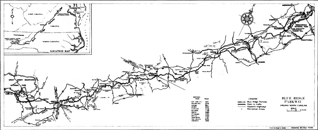
The project is 480 miles long, averages 2,500 feet in elevation, and will connect Shenandoah and Great Smoky Mountains National Parks. It is the longest road ever to be planned as a single unit in the history of American road-building. But the real interest of the work lies in the dramatic variety of the vast mountain country being made accessible, the thought that the motorist will travel for nearly the entire length of two southern states always in the invigorating coolness of the high mountains, and that through this first tourway will come the fusion of two of America's most popular national parks into one huge recreational system. Mindful of the many cliffsides, chasms and spur ridges that lay ahead to thwart passage of a modern motorway along the Blue Ridge, more than one expert planner predicted that it would "fall of its own weight" when this $30,000,000 proposal first was made five years ago. Now, with more than 100 miles ready for traffic and an additional 190 in various stages of construction, and with the entire route plotted on survey maps a steady advance toward its completion seems reasonably assured. Its character and usefulness should be amply demonstrated during the next two years as added miles are opened to connect a continuous route from Roanoke, Virginia, to Asheville, North Carolina. The completed portions, such as may be seen by visitors to the work below Blowing Rock and Roanoke, will differ greatly from the usual commercial highway principally because of the parkway idea. Likewise, and because it constitutes a first adaptation of the broad right-of-way to a rural region, it will differ from such parkways as Colonial and Mt. Vernon, and those near New York City which have proved so sound in the suburban plan. It will bear only remote likeness to the Skyline Drive in the Shenandoah even though it was from the enthusiastic reception of that road by the public that the Blue Ridge project had its birthright.
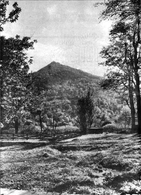
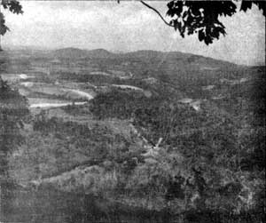
According to the parkway principle, the states of Virginia and North Carolina, through their highway departments, are acquiring for the federal government what is in effect a recreational area 480 miles long and about 800 feet wide. Through this ribbon-like park is built the motorway, and instead of sign boards and hot dog and gasoline shanties, a naturally beautiful roadway becomes possible of preservation, and where despoiled, possible of landscape improvement. In effect, an ever-to-be green, and, in places, a primitive cross section of the eastern highlands has been set aside for motor recreation. The acquisition of thousands of private tracts more or less in the immediate path of the steam shovel has required the closest cooperation between state and federal forces. Studies by the Service call for a taking which varies in width from 200 to 1,200 feet, and the requirements must be judged as much for effect upon the residual property as for control of the roadside picture. Private and public roads, cattle crossings, water rights, and phone and power lines seriously involve the entire economy of many larger mountain properties. Relocation of these facilities must be arranged or the entire holdings purchased outright. Those considerations and the natural tendency of many mountain people to hold to the old homes of their forefathers combine to make a more than usually difficult problem of acquisition, especially if condemnation is to be avoided. The Blue Ridge Parkway is laid out expressly as a route for the leisurely tourist, but there has been little compromise in meeting the requirements of safety, reasonable speed, and ease of driving. Viaducts, tunnels, retaining walls and other special devices of the highway engineer have been employed in subduing the sharp curves and steep grades that we associate habitually with the mountain road. This maintenance of a high standard of modern road has meant the "scar" of machine construction in certain rough and steep-sided mountains. Occasionally the excavation to create the 30-foot road section mounts as high as 100,000 yards to the mile. Technicians are confident nevertheless that landscape and erosion control work, combined with time, will largely erase this evidence of Diesel power and dynamite. For the sake of safety, native stone and timber bridges carry the Parkway over or under important transmountain highways and do away with the crossing of traffic at grade. Operating policy will limit the use of the drive to passenger cars only, eliminating the annoyance of the large truck and bus. In order to keep construction costs within reasonable bounds while still maintaining standards of curvature and grade, and what is more, to avoid excessive scar, it has been necessary to skirt some of the more rugged regions with the result that the Parkway does not exclusively follow the skyline, but assumes a changing position in the mountains. Like the movie cameraman who shoots his subjects from many angles to heighten the drama of his film, so the shifting position of the roadway unfolds a more interesting picture to the traveler. The sweeping view over the low country often holds the center of the stage, but seems to exit gracefully enough when the Parkway leaves the ridge for the more gentle slopes and the deeper forests. The panoramic landscapes seem even bolder for these contrasts. Of quite different character, but still of interest to the overall pattern, are the quiet fields and pastures which make unusual designs in many high land sections. Here among the strange bluffs and crags and waterfalls an abandoned log cabin, or a water mill long past its days of grinding grist, chronicles the human history of these very old American mountains. As much as possible these featured players of nature and of history on the Blue Ridge have been billed for continuous performance, and funds made available to the Service have been used to acquire many of them in their setting and well beyond the normal widths of right-of-way. In places an area of 6,000 to 10,000 acres embraces a whole group of mountains. Selected also for logical distribution along the Parkway, roughly at 20-mile intervals, these parks will provide the setting for wayside travel facilities. Several areas are being developed now through the Civilian Conservation Corps and Emergency Relief Administration work programs. Picnic and camp grounds, motor service stations, coffee shops and modest lodges will complement those of the tourist towns scattered through the mountains, rounding out a self-contained motor vacation land. Along with the provision of facilities for many forms of active recreation, large areas in these parks will remain undeveloped so that the adventurous may withdraw from the Parkway traffic to tramp or fish in the unbroken forests. Among the notable geographic features of the Parkway route in Virginia are the George Washington and the Jefferson National Forests, the Peaks of Otter, and the Pinnacles of Dan; and in North Carolina, Grandfather Mountain, Linville Gorge, the Craggy Gardens, and Mount Mitchell, the highest elevation east of the Rockies. Rounding Asheville the Parkway will dip downward to cross the French Broad River and then will rise high in the Pisgah National Forest to approach the Great Smoky Mountains, probably near the Qualla Indian Reservation of the eastern Cherokees. Plans for maintenance and protection of the Blue Ridge Parkway by the Service call for headquarters areas at 60-mile intervals, or in each third park. Management of traffic on the Parkway and ranger patrol of an aggregate boundary of 1,000 miles, along which abut many private holdings, necessarily will develop problems of administration, certain elements of which will be peculiar to the Parkway work. Take for example the problem of maintaining Parkway lands. The charm of many sections in the Blue Ridge lies in the farm fields and pastures. Should these cultivated areas or the Parkway strip itself be allowed to return to forest indiscriminately, many of the fine views would be lost. The Service can hardly expect to grow the corn and wheat, or to tend the cattle in the pastures, and so has resorted to leasing at nominal rentals those Parkway lands naturally adapted to cultivation. In this manner the roadside picture will be maintained without cost to the United States and better neighbors will be made of nearby farmers.
The Blue Ridge Parkway is being built under contracts supervised by the Public Roads Administration whose engineers have prepared the plans collaboratively with the Service in accordance with the interbureau agreement. Amid much talk of a nation-wide system of parkways and freeways the steady advance toward completion of a pioneer national tourway seems especially timely. While any national system doubtless would concern itself primarily with motorways that will serve as express regional routes, many planners believe that there is a place for the road of the purely recreational type. Since the Blue Ridge Parkway will provide days or weeks of well rounded vacation high above the summer temperatures, remote from the towns and cities and yet within a single day's travel for 60,000,000 persons, it should test amply the soundness of the idea. Many officials see emerging from this and from the Natchez Trace Parkway programs a strong case for a new means of bringing national parks closer to the people. | ||
| <<< Previous | > Contents < | Next >>> | ||
|
http://www.cr.nps.gov/history/online_books/regional_review/vol3-1b.htm Date: 04-Jul-2002 | ||||