|
| ||||||||||
| Intro | Author | Subject | Volume | Volume/Title | NPS | |||||
|
Volume IV - Nos. 4 & 5 |
April-May, 1940 |
|
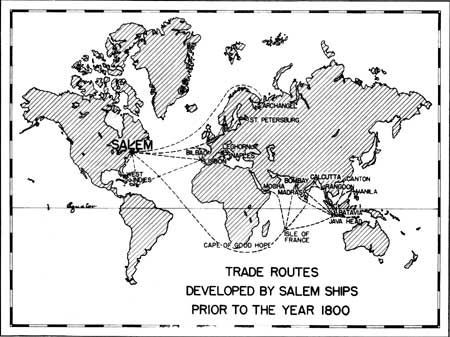
The newly completed special map reproduced above affords a graphic and quickly comprehended representation of the trade routes plied by the ships of Salem when that resourceful Massachusetts port won a commanding share of the commerce of the seven seas and became the most famous harbor of the New World. Salem Maritime National Historic Site, which includes more than a mile of waterfront, contains Derby and Central Wharves, and several buildings associated intimately with the period of Salem's brilliant achievements on the oceans of the world. Extensive repairs carried out by the Service on the wharves, two fingers extending far into the harbor, assure preservation of outstanding physical survivals associated with the foundations of America's foreign trade. Consequently, even though the swift vessels and purposeful men of Salem's intrepid merchant fleet disappeared long ago from the hazardous paths of the sea, the site from which they entered those devious lanes constitutes a perpetual memorial to Yankee resourcefulness, daring, and hardihood in a struggle against world competitors. Salem was the first of the national historic sites placed under jurisdiction of the National Park Service. Federal Hall, in New York, and Hopewell Village and the Philadelphia Customs House, in Pennsylvania, have been added to the list. | |
| <<< Previous | > Contents < | Next >>> | ||
|
http://www.cr.nps.gov/history/online_books/regional_review/vol4-4-5j.htm Date: 04-Jul-2002 | ||||