|
Watering the Land: The Turbulent History of the Carlsbad Irrigation District |

|
CHAPTER SIX
A Permanent Presence: The Reclamation Service Takes Over
While the Reclamation Service and Pecos Irrigation Company pursued their futile 1905 attempt to restore irrigation service, other developments began to lay a framework for future, large-scale rehabilitation and long-term Federal involvement. Throughout the 1905 season, Hall, Myers, and their technical crews surveyed and mapped the region, preparing both geological reports and engineering studies of the existing reclamation system and of a possible government rehabilitation effort (to be known as the "Carlsbad Project"). To the Reclamation Service field personnel and local farmers, these efforts seemed a reassurance that Federal takeover of the irrigation system was imminent. No such transfer had yet taken place, however, and negotiations and uncertainty on that front continued throughout much of the year.
|
| After acquiring the Carlsbad reclamation project in December of 1905, the U.S. Reclamation Service began preparing construction drawings for the repair of Avalon Dam. — Denver Branch, National Archives, Denver, Colorado; August 1906. |
One of the first field studies was completed in March 1905 by Thomas Means, an "Engineer of Soils" for the U.S.G.S. His report identified some 52,300 acres of "first and second class land" (well-suited for irrigation) within the Carlsbad area. He chided the area farmers for their neglect of fertilization, drainage control, and other scientific agricultural practices, noting that current practices were both limiting crop yields and damaging the soil. He stated, however, that with irrigation and appropriate farming practices "any intelligent man willing to work should successfully manage any first class land under the Carlsbad Project and be able to pay for his water right and adequately support a family. Many men could put money in the bank each year in addition." [1]
Meanwhile, the Reclamation Service mapping and survey crew completed extensive triangulation work and contour mapping of the McMillan and Avalon Dam sites and other irrigation company facilities. These studies were apparently intended as the base materials for any future Federal reconstruction work. Geological and engineering reports were also prepared for the same purpose. Much of this work culminated in an August 31, 1905 report to the Reclamation Service Chief Engineer, summarizing the local situation and recommending a plan for government action. This document was signed by an appointed five-member board of engineers which included Reed and Hall, but not Myers.
|
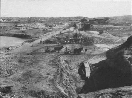
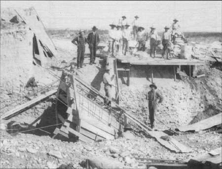
| Construction of the new, rockfill Avalon Dam began in June 1 — Carlsbad Irrigation District, Carlsbad, New Mexico; ca. 1907. |
The board's report reaffirmed the seriousness of the local water situation and recommended a Federal takeover of the project. Existing reservoir storage capacities suggested to the board that a Federally-managed system would be able to irrigate approximately 20,000 acres of farmland, and an analysis of local economic and agricultural conditions indicated that a maximum construction assessment of $30 per acre could be levied on the land to be served. (Reclamation Service projects were intended to be financed through time-payment assessments on a district's farmland.) These figures produced a maximum project budget of $600,000. Repair costs to the existing system were estimated at $450,000, thus suggesting a $150,000 purchase price for the irrigation company's assets. This figure was substantially less than the company's original $350,000 asking price, and only a small fraction of the total capital investment in the physical plant. Nevertheless, the board considered the $150,000 price to be fair, in light of the facility's ruined condition.
|
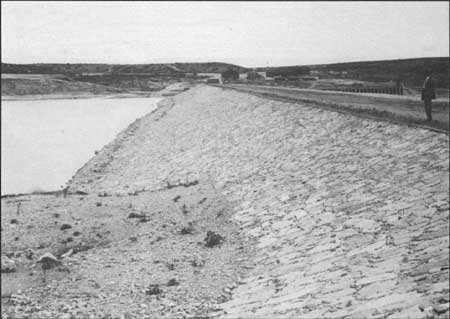
| The earthfill on the upstream face of the dam was riprapped with limestone to prevent erosion. — National Archives, Washington D. C.; May 22, 1908. |
These financial constraints caused the board of engineers to recommend that the Carlsbad Project be undertaken, but only if the Pecos Irrigation Company agreed to the $150,000 sale price. If their agreement was not forthcoming, the board recommended that all work on the project cease. The company was given a September 30 deadline to accept the sale price.
Additionally, the board noted that other nearby lands existed which could benefit from irrigation. The construction of a third storage reservoir, Reservoir No. 3, was considered as a possible means of expanding the scope of the project. The Reservoir No. 3 site, approximately midway between McMillan and Avalon Reservoirs, had been considered as a possible storage dam site since at least the 1890s. The board concluded that the construction of Reservoir No. 3 could effectively double the project acreage at the same per-acre cost. Some mapping and geologic activity had already been performed at the site, and the board suggested that analysis of Reservoir No. 3 be continued. If the reservoir site proved feasible, the board recommended that it be "taken up for construction." [2]
|
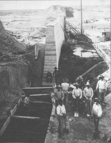
| The reconstructed Avalon Dam featured a thin concrete corewall. — Carlsbad Irrigation District, Carlsbad, New Mexico; ca. 1907. |
Federal evaluation of the Reservoir No. 3 site continued throughout the autumn of 1905. The geologists working there received a small surprise that November, when one of their drill cores suggested that the discovery of an "oil or asphalt" field might be imminent. Hall briefly suggested that the Reclamation Service could "turn this discovery to account in some way and supply the proceeds to the Carlsbad Project," but nothing apparently came of the idea. [3] The final report on the reservoir site, prepared by Willis T. Lee in December 1905, did not mention petroleum products. Instead, Lee emphasized the presence of gypsum deposits beneath the reservoir bed. Gypsum is a highly porous, soluble mineral which virtually dissolves beneath a reservoir floor; similar deposits contributed to the failure of the Hondo Project and were responsible for substantial leakage at McMillan. Consequently, Lee doubted that the reservoir would hold water, stating that "there is little to favor the project and very much to discourage it. [4]
|
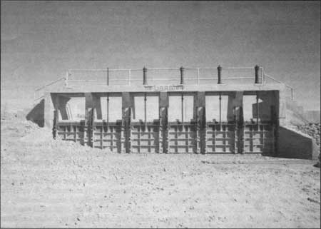
| The new outlet works at Avalon contained six wooden sluice gates operated by ball-bearing gate stands. — Denver Branch, National Archives, Denver, Colorado; ca. 1908. |
Meanwhile, the process of transferring the Pecos Irrigation Company's physical plant to the Federal government proceeded at a faster pace. Although Tracy and the irrigation company's investors were unhappy with the financial ultimatum specified in the August 31 report, they had agreed to the sale by September 23. [5] The water users association continued to bombard the Reclamation Service, the Secretary of the Interior, and other government officials with emotional pleas for rapid intervention. Although there was still some official doubt that the Secretary of the Interior would approve another large reclamation project, he formally did so on November 28. His decision set aside the requested $600,000 from the Reclamation Fund, and authorized work to begin subject to several conditions. The Pecos Irrigation Company was required to transfer its reclamation system with clear title, and to agree to dispose of its agricultural lands "in tracts not exceeding 160 acres, so that the same may become subject to the provisions of the Reclamation Act." [6] (The Act required landowners receiving Federal irrigation water to reside near their farms and to own no more than 160 irrigable acres.) In turn, the water users association members were required to contract for the project's water at a price sufficient to pay for the project's construction, operation, and maintenance costs. [7]
|
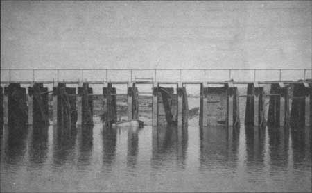
| An innovative design element at Avalon Dam involved the introduction of "quick acting emergency gates "for Spillway Number 1. The interesting wooden gates never performed adequately and were eventually replaced. — Carlsbad Irrigation District, Carlsbad, New Mexico; August 5, 1911. |
All parties involved worked rapidly to comply with the Secretary of the Interior's conditions. On December 5, Reclamation Service and irrigation company officials completed an agreement in principle on terms of the irrigation system transfer, and a warranty deed was executed on December 18, 1905. The same day, the water users association held a special meeting to approve the necessary contracts with the government. As the government's fiscal agent for the Carlsbad Project, the water users association served as the contractual and financial intermediary between the Reclamation Service and the farmers. By December 28, the water users had subscribed 10,512 irrigable acres for the project; an additional 21,168 acres was under contract for water but needed to be subdivided and transferred to individual owners. (Nearly two-thirds of the latter acreage was owned or controlled by either Tracy or the Pecos Irrigation Company.) On that date, the Geological Survey notified the Secretary of the Interior that his conditions had been "substantially complied with," and a rapid beginning of construction was recommended. [8] The following January 23, Hall formally notified the New Mexico Territorial Engineer that the Federal government would be appropriating all previously unused Pecos River water — the equivalent of 300,000 acre feet per year — for use by the reclamation project. In doing so, the government was essentially re-filing for the water rights claimed by the Pecos Irrigation Company. [9] As late as 1923, lacking a formal adjudication of Pecos River water rights, the government claimed the Carlsbad Project to have senior rights subject only to prior beneficial use of small tracts by "Mexicans and Indians." [10]
|
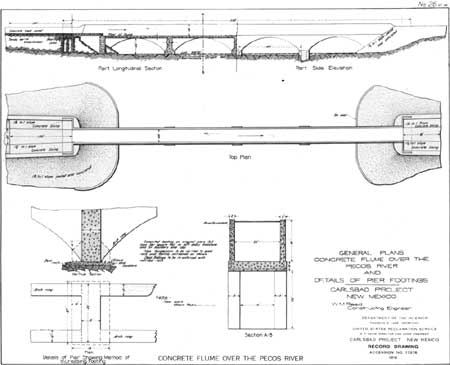
| The Federal government spent $18,000 in repairing and widening the Pecos River flume. — Denver Branch, National Archives, Denver, Colorado; ca. 1905. |
The Reclamation Service quickly prepared to solicit contractors for the rebuilding of Avalon Dam; the remaining, smaller rehabilitation work would be constructed directly by the Reclamation Service under "force account." (Force account projects were those directly undertaken by Reclamation Service crews rather than by government contractors.) By the end of 1905, much of the necessary engineering work for the Avalon Dam reconstruction had been completed and construction was ready to begin. A number of design alternatives for the dam had been formulated during the year, including a reconstructed rockfill dam with a new steel or concrete core and the replacement of the dam with a "concrete overfall dam" upstream from the former site. Primarily for cost reasons, it was eventually decided to rebuild at the original site, and to reuse that portion of the original dam which remained standing. The Reclamation Service completed final drawings and specifications for the Avalon Dam project early in 1906 and issued a request for bids, but no offers were received. In April, the government decided to erect the dam itself by force account. Preliminary work at the site began on May 1, 1906, and construction was underway by June 1. Work progressed from both ends of the structure simultaneously. [11]
|
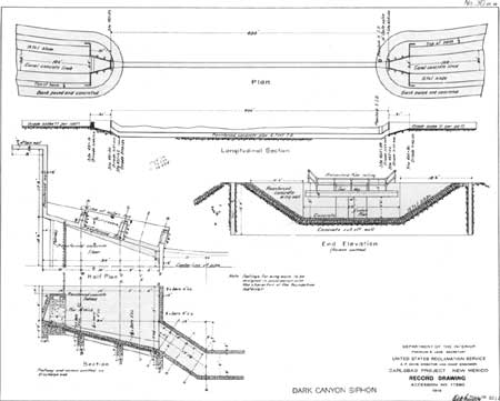
| A 400-foot-long reinforced concrete siphon carried the irrigation water beneath the floor of Dark Canyon. — Denver Branch, National Archives, Denver, Colorado; ca. 1905. |
The Reclamation Service designs for Avalon Dam reflected many of the contemporary advances in dam engineering and technology. By the early 1900s, it had become a common practice to place a corewall of some type in earthen and rockfill dams. The corewall was intended to serve two functions: it prevented water moving in riverbed gravel beneath the earthfill from creating channels which could eventually undermine the dam's foundation and it prevented burrowing animals from making tunnels through the dam that could enlarge in response to water pressure. After taking material bids for a proposed steel sheet piling core, B.M. Hall, the project's supervising engineer, recommended the substitution of a thin concrete corewall. Though the cost of the steel sheet piling was a probable factor, Hall also feared that the river's high salt content would result in rapid deterioration of the steel. Reclamation engineers in Washington, D.C., approved Hall's request, but increased the thickness of the diaphragm. [12]
|
| The siphon eliminated the problem of flash flooding which had destroyed portions of the main canal during previous years. — Carlsbad Irrigation District, Carlsbad, New Mexico; November11, 1907. |
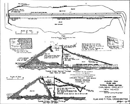
As built, the new rockfill dam featured a rubblestone concrete corewall that was 3 feet wide at the top and battered 1:24 on both sides. A 200-foot section of the wall near the eastern abutment was designed with a much thicker cross-section to serve as an overflow weir during construction of the dam. The flow of the river was directed over this weir until construction reached a point where the river could be diverted into the canal. To avoid trenching in the surviving portions of the old dam, steel sheet piling was substituted for the concrete. The entire corewall, both concrete and steel, was topped with a 24 foot high concrete diaphragm running the length of the dam.
|
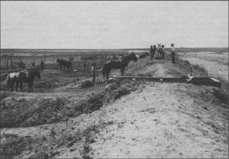
| In addition to reconstructing Avalon Dam, the U. S. Reclamation Service built an earthen embankment along the Main Canal to more efficiently channel irrigation water. — Carlsbad Irrigation District, Carlsbad, New Mexico; July 18, 1906. |
The width of the rockfill crest of the dam was increased 33 feet on the upstream side of the dam to permit the corewall to clear the inside slope of the rockfill surviving from the former dam. The earth fill on the upstream face of the dam, while retaining the original 3.5:1 slope for approximately one-half of the height of the dam, was then increased to a 2:1 slope to the crest. The earth-fill was riprapped with limestone. The rebuilt Avalon Dam was 1,025 feet long and up to 50 feet high. [13]
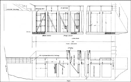
Other work at Avalon included the construction of a new concrete headworks structure with 6 sluice gates operated by ball bearing gate stands and the reconstruction of Spillway No. 1. The new concrete Spillway No. 1 featured 39 pairs of wooden, "quick acting emergency gates of special design," each 5 feet wide and 10 feet high. One gate of each pair opened upstream, the other downstream. The inner door in one opening was connected by cables and pulleys to the outer door in the adjacent opening. The Reclamation Service purported the doors could be "quickly opened and closed by water pressure". [14] The novel design of the new gates would be severely tested by the Pecos River within a matter of years.
Avalon's two other spillways, both of the overflow type and surviving from the original dam, were enlarged and improved. Portions of these spillways are carved directly into the site's natural rock formations. The new spillway configurations featured a substantially larger capacity than those of the former structures. [15]
As the work on Avalon Dam began, planning was underway for smaller-scale rehabilitation efforts on virtually every other segment of the irrigation network. The largest of these additional projects involved completing the aborted rehabilitation of the Pecos River flume. The Reclamation Service spent nearly $18,000 repairing cracked concrete, widening and strengthening the footings, and lengthening the structure to reduce bank erosion. A new siphon across Dark Canyon became the canal's second major concrete structure. This structure was designed to convey the main canal beneath the floor of Dark Canyon, thus eliminating the washouts caused by the canyon's perennial flooding. The siphon, some 400 feet in length, was constructed during the winter of 1906-1907.
Elsewhere along the major canals, work emphasized the building of an embankment along the canal's uphill side. The original irrigation company canals were generally banked only on their downhill slope, thus allowing the water to spread out into arroyos and low areas on the upper side. Although the irrigation company claimed that this arrangement created additional "reservoir" space to hold flood waters for return to the canal, the Reclamation Service noted that this caused an "enormous" loss of water from seepage and evaporation. [16] Other sections of the canal system suffered from excessive seepage due to the presence of subterranean gypsum deposits. Portions of these areas were fully lined with concrete. A segment of entirely new canal was also constructed near the project's southern boundary, allowing excess water from the Main Canal to be used in the separate Black River canal system.
The Reclamation Service also installed new spillway structures and control gates in the major canals during the winter of 1906-1907. Substantial multi-gate spillway facilities were placed at the bifurcation point of the Main and East Side Canals, above the Dark Canyon Siphon, and at Cass Draw. The latter two placements allowed the canal's entire flow to be returned to the riverbed if necessary. Additional gates at the bifurcation point controlled the relative flow of water down the two branch canals. The Reclamation Service's new spillways and gates were of concrete, replacing the antiquated wooden structures of the irrigation company.
The Reclamation Service also recognized that various structural improvements would be needed at McMillan Dam. The 1904 flood had not rendered McMillan inoperable, however, so the government postponed any McMillan work until after the other projects were completed and the system was returned to service. Consequently, McMillan was largely untouched by the Reclamation Service until 1908.
Also in 1906, Federal soil scientists began the task of identifying the specific sections of farmland that would be served by the completed project. Much of this work was performed by Lewis E. Foster, an assistant engineer for the Reclamation Service. (Foster later served a long tenure as the Reclamation Service's Project Manager at Carlsbad.) Foster carefully mapped the soils of the survey area and prepared brief analyses of potential agricultural practices in the region; his, report was intended to ensure that the highest quality soils were the ones that received the benefits of irrigation. [17] As the final land selections were made later in the year, however, decisions based on science were occasionally tempered by legal and political realities, including the Reclamation Act's restriction of 160 acres per person. An additional complication involved those individuals who owned water rights dating from the private irrigation company days, but whose land was in the "gypsum districts," and not considered irrigable by Federal engineers. To accommodate these rights, some tracts of less-than-prime land were admitted to the system. The final listing of lands to be irrigated was approved by Reed and submitted to the Chief Engineer on August 15, 1906. [18]
|
| New concrete and steel diversion gates were installed at the major diversion points of the canal network Main Canal, Wasteway 1. — Fred Quivik, February 1990. |
Most of the work needed to restore irrigation water to the area had been completed by early 1907. Official histories of the construction phase suggest that all work proceeded smoothly and according to schedule. Nevertheless, the construction period was marked by recurring themes of discord and strained relations, both within the Reclamation Service itself and among the Service, the Carlsbad townspeople, and the Pecos Irrigation Company. Many of these difficulties grew from allegations of Reclamation Service mismanagement of the Carlsbad Project — allegations that would continue for years. For example, on May 29, 1906, Gerard H. Matthes, an engineer working on the Carlsbad project, prepared a scathing letter to the Reclamation Service's Chief Engineer complaining that "Indifference to existing regulations, slipshodness and unbusiness like proceedings have characterized the workings of the project office." Matthes' long list of charges was rebuffed by other project staff as a smokescreen to cover Matthes' continued "failure to perform his assigned duty," but it was nevertheless an indication of significant discord within the project staff. [19]
Similar concerns were expressed by others throughout the duration of the construction period and beyond. As early as September 1905, Newell noted that he was "disappointed at the failure of the work [at Carlsbad] under Mr. Hall," referring both to the failed temporary dam and the other Reclamation Service efforts then underway. Newell requested that a Utah consulting engineer provide him with a "confidential letter" evaluating the work at Carlsbad. The resulting report at least partially confirmed Newell's suspicions. [20] By 1906, these doubts began to spread throughout the Carlsbad community. The Matthes affair somehow became public knowledge, and Tracy continued to voice strong public objections to the methods and quality of the Reclamation Service's local operations. A second U.S.G.S consulting engineer, C.E. Grunsky, examined the project during June 1906 and was quickly visited by the directors of the water users association, who requested information "in order that they might reply intelligently to questions and criticisms of the proposed works." Grunsky's report concluded:
. . . it was apparent that the community was divided on the question of the professional ability of the engineers representing the Reclamation Service at Carlsbad, and that the efficiency of the proposed work on the Avalon Dam had been called into question by someone. [21]
The "someone" referred to was obviously Tracy, who paid Grunsky a call and "expressed a lack of confidence in the stability of a dam [Avalon] substantially. . . of a similar type to the structure which failed." [22]
As Tracy and the others continued to promulgate disparaging comments about the Carlsbad Project, construction crews began nearing the point where Avalon and the canals could once again begin providing irrigation water. Although the canals remained dry for a second season in 1906, enough work was completed by early 1907 to provide water to a portion of the project acreage. Water was first turned into the canals on March 25, and some 6,000 acres of land received irrigation water that summer. [23] This was not considered a formal "opening" of the project, but rather an "emergency" use, intended only to save the orchards and crops which had now been without water for two years. Construction activity continued on Avalon Dam and the canals during the irrigation season. [24]
The reopening of the canal headgates was a natural source of jubilation for Carlsbad residents, and the town petitioned the territorial legislature to proclaim a "New Mexico Irrigation Celebration" as a means of expressing thanks for the Reclamation Service's work throughout New Mexico. The festivities, financed by local subscription, were staged in Carlsbad during July 3, 4, and 5, 1907. Although the celebration was considered a success, its organizers were bitterly disappointed that high-level invited representatives from the Reclamation Service and Department of Interior failed to attend. They termed the celebration "playing Hamlet with the Prince of Denmark left out." [25]
Endnotes
1. Thomas H. Means, "Report on Agricultural Possibilities of the Carlsbad Project, New Mexico." RG 113, Entry 3, Box 438, File 338, National Archives, Washington, D.C.
2. W.M. Reed, et. al. to the Chief Engineer, U.S. Reclamation Service, August 31, 1905, RG 115, Entry 3, Box 443, File 651, National Archives, Washington, D.C.
3. B.M. Hall to the Chief Engineer, Reclamation Service, November 22, 1905, ibid.
4. Willis T. Lee, "Report on the Geology Near Carlsbad, New Mexico [December 1905]," ibid.
5. F.G. Tracy to F.H. Newell, September 23, 1905, ibid.
6. Chief Engineer, Reclamation Service to Pecos Water Users' Association, December 1, 1905, RG 115, Entry 3, Box 443, File 652, National Archives, Washington, D.C.
8. Director, U.S. Geological Survey to the Secretary of the Interior (with attachments), December 28, 1905, ibid.
9. Herbert W. Yeo, "Report on the Present and Future Duty of Water on The Carlsbad Project, New Mexico," Pecos Valley Projects Office, Bureau of Reclamation, Carlsbad, New Mexico.
10. "Report on Investigations Pecos River and Carlsbad Project Extensions in New Mexico, May 1923," RG 115, Entry 7, Box 451, File 301, National Archives, Washington, D.C.
11. "History of Carlsbad Project — 1912."
12. B.M. Hall, "Reinforced Concrete Diaphragms for Earth Dams," Engineering News 59 (February 6, 1908): 145. For discussions regarding the design of the core wall, see correspondence in: RG 115, Entry 3, File 449, File 895, National Archives, Washington, D.C. Interestingly, Hall designed a 92-foot high dam in Puerto Rico two years later with a 6-inch core wall through its entire height.
13. "Plan and Typical Cross Section, Avalon Dam," Record drawing, Accession No. 17353, Box 16, Federal Records Center, Denver, Colorado. Also see "[Carlsbad] Project History from Inception of Project to December 31, 1913."
14. Sixth Annual Report of Reclamation Service, 1906-1907 (Washington: GPO for Department of the Interior, 1907), 150; untitled construction drawing of the gates, Number 5-500-231, Box 16, National Archives, Denver Branch, Denver, Colorado; "History of Carlsbad Project — 1912."
15. "[Carlsbad] Project History from Inception of Project to December 31, 1913," 5-9.
16. Fifth Annual Report of the Reclamation Service, 1907 (Washington: GPO for Department of the Interior, 1908), 147-150.
17. Lewis E. Foster, "Soils and Agriculture of the Carlsbad Project," 1907, RG 115, Entry 2, Box 438, File 338, National Archives, Washington, D.C.
18. W.M. Reed to the Chief Engineer, U.S. Reclamation Service, August 15, 1906, RG 115, Entry 3, Box 441, File 338-B, National Archives, Washington, D.C.
19. W.M. Reed, et. al. to B.M. Hall, June 23, 1906, RG 115, Entry 3, Box 441, File 466, National Archives, Washington, D.C.
20. F.H. Newell to W.H. Sanders, September 27, 1905; W.H. Sanders to F.H. Newell, October 13, 1905, RG 115, Entry 3, Box 443, File 651, National Archives, Washington, D.C.
21. C.E. Grunsky to the Director, U.S. Geological Survey, June 27, 1906, ibid.
23. W.M. Reed to the Director, U.S. Reclamation Service, November 22, 1907, RG 115, Entry 3, Box 438, File 338-A1, National Archives, Washington, D.C.
24. H.C. Rizer to the Secretary of the Interior, November 22, 1906, ibid.
25. C.H. McLenathen to Frederick H. Newell, July 8, 1907, RG 115, Entry 3, Box 441, File 466-B, National Archives, Washington, D.C.
| <<< Previous | <<< Contents>>> | Next >>> |
rmr/0/chap6.htm
Last Updated: 01-Feb-2008