|
Watering the Land: The Turbulent History of the Carlsbad Irrigation District |

|
CHAPTER 8
Homes for All Who Come: Promoting the Carlsbad Project
As the first decade of the 20th century progressed, Reclamation Service operation of the Carlsbad Project became more and more routine, and gradually the system became able to reliably irrigate additional acreage. During the Carlsbad Project's first twenty years, however, the amount of land served by irrigation was consistently less than the project's stated capacity. A number of reasons contributed to this land surplus, including the perennial "excess holdings" issue and an exodus of homesteaders during the dry years of 1905-07.
The under-utilization of Carlsbad Project water was not viewed favorably by either the Federal government or local settlers. The Reclamation Service almost certainly realized that a fuller utilization of its water projects would increase the agency's perceived efficacy and value, while Pecos Valley businessmen longed for the increased economic activity that additional settlers would bring. Consequently, a number of organized efforts to attract settlers to the Pecos Valley materialized during the 1900s, 1910s, and 1920s. These programs were variously supported by the Carlsbad Commercial Club, the water users association, the Santa Fe Railway, and the New Mexico territorial and state government. This official advertising supplemented the active, ongoing promotions of local realtors and land speculators. Most such efforts, both private and public, seemed to receive at least the tacit approval of the Reclamation Service. In 1914, the Reclamation Service even offered to maintain "an open list of lands for sale" at its Carlsbad Office. [1]
|
| The local water users' association actively promoted colonization of the project's lands during the first decades of the 20th-century. The advertisements included brochures such as this one published around 1912. — Carlsbad Irrigation District, Carlsbad, New Mexico. |
Many of the earliest promotional efforts were sponsored by the New Mexico Bureau of Immigration, a territorial agency which had actively promoted Pecos Valley settlement during the old irrigation company days. A 1908 publication titled "Eddy County, New Mexico" is typical; the booklet's subtitle describes the county as:
A Land Where the Soil is Rich and Deep, the Water Abundant and Prosperity for the Industrious Farmer Assured. [2]
The brochure provided prospective farmers with detailed descriptions of the Carlsbad Project, as well as "the world-famous Pecos Valley artesian belt" near Roswell. Hopeful immigrants were enticed with glowing portraits of the county's varied crops, including the "famous... Carlsbad Peach." The booklet's message was obvious: the verdant Pecos Valley was ready to provide bountiful "[h]omes for all who come." [3]
Over the years, numerous other publications echoed the message and tone of the 1908 brochure. Often, such promotional brochures and posters would be accompanied by more active recruiting and salesmanship. One such program was instigated in 1916 by the owners of some of the project's surplus lands. Ostensibly working to reduce their unauthorized holdings within the project, the landowners reportedly:
decided that it was time for them to offer their lands to the farmers of other sections.... They, therefore, agreed to list their lands with their association, and contracted with C.F.C. Ladd, of Kansas City, Mo. to act as their colonization agent. The association will maintain an office in the Union Station, Kansas City. Mr. Ladd will have a corps of good agents in the field to acquaint prospective buyers with the rich lands and attractive farm conditions at Carlsbad, and induce them to inspect them. [4]
Although the Carlsbad Project's irrigable lands slowly began to fill, organized land promotion activities continued until the mid-1920s. In 1924, landowners in Carlsbad, Artesia, and Roswell banded together as the Pecos Valley Association and began a $7,500 newspaper advertising program in conjunction with the Santa Fe Railway. (The railway maintained an active colonization office in Chicago which worked to recruit settlers to all the railway's on-line communities.) The first day of advertisements reportedly generated "one hundred inquiries from twenty-one states and one from Canada," and the effort's apparent success elicited positive interest from the Reclamation Service hierarchy. It was among the Project's last promotional undertakings, however; by late in the decade little project land was available for new settlers. [5]
Dissension and Politicking The Carlsbad Project in
the 1910s
Tracy continued to annoy Department of the Interior officials throughout the 1910s, his unhappiness presumably increasing due to the 1911 controversy involving the Avalon cylinder gates. His anger grew more vocal that year, as he began pushing his cause locally through a series of opinionated letters in the Carlsbad Argus. Late that year Tracy adopted a new tactic, attempting to use the Pecos Water Users Association as a mouthpiece for his views. At a meeting of the association's board of directors that October 28, a sharply divided board voted to send the corporate secretary, Scott Etter, to Washington, where he would rendezvous with Tracy and the pair would submit a joint protest against Reclamation Service policies at Carlsbad. Such a protest was seen by at least one Carlsbad observer as an attempt "to legally test [the Reclamation Service's] present claim on this project, in short their ultimate object is to wrest the project's control from its present management." [6] Before Etter's departure, he reportedly received an afternoon of coaching at McLenathen's house. [7] Soon after Etter headed east, however, a mass meeting of the project's farmers convened and telegraphed Washington, stating:
He [Etter] has gone in entire ignorance and absolute defiance of the desires of the actual farmers and we request that he be given no hearing as our representative.... [8]
It was apparent that Tracy's efforts enjoyed, at best, support from only one faction of the water users membership. He was forcefully opposed by P.J. McShane, the association's president and an Irishman "with plenty of fighting blood in his veins." [9] Nevertheless, the Washington trip went ahead. At their meetings, the Reclamation Service patiently listened to Tracy and Etter and returned the same carefully measured, unflinching responses that had been irritating Tracy for years. The Reclamation Service's director, however, suffered a brief embarrassment during the visit when he was unable to locate drawings of the Avalon cylinder gates. (Etter's irrigation company career displayed controversy in later years, as well; in 1915, a Reclamation Service auditor suspected that Etter was "a crook," who delayed in transferring landowners' fee payments from the water users to the Federal government in order to make personal use of the money. [10])
Tracy's visit to Washington and his subsequent letters now took the position that the Pecos Irrigation Company's 1905 contract with the Federal government gave the company's lands a right to receive water from the Carlsbad Project, and that by not honoring that right the Reclamation Service was depriving the company of its major financial consideration in the sale. The sale documents had granted such a water right provided that the holders of existing rights were first served, and if it was deemed "economically practicable" to do so. [11] While Tracy maintained that it would be quite feasible for the government to construct Reservoir No. 3 and service the irrigation company's lands, the Department of the Interior countered that the reservoir site's porous soils would give it only enough capacity to compensate for the rapidly-decreasing capacity of McMillan due to the constant siltation. As Tracy continued to loudly denounce the government's bad faith, the Department of the Interior attempted to simply ignore Tracy's barbed missives as long as possible. Although it did nothing to quiet Tracy, there was considerable pleasure in the Department of the Interior when Reed unearthed a copy of Tracy's 1904 annual report to the irrigation company's shareholders, in which Tracy complained of a dismal financial outlook and recommended selling the irrigation system to the United States for the benefit "at least to the people under it." [12]
Although officials in Washington consistently did their best to ignore Tracy's requests for satisfaction, at least one local Reclamation Service officer did wonder about the Service's "moral and legal obligations to the P.I. Co." [13] In April 1913, Louis Hill noted that the recent improvements at McMillan would allow an increase in the project's acreage, and questioned whether the Reclamation Service should supply water to company land near Malaga (several miles south of the Project's current limits). Davis emphatically replied that "in the opinion of this office all our moral obligations to the company have been discharged," and he recommended that other lands nearer the existing canal network be serviced instead. [14]
Tracy's efforts continued unabated for the remainder of the decade, without visible results. In 1913, he went so far as to publish a pamphlet, "Reasons for Immediate Completion of the Carlsbad Project," in which he continued to advocate the construction of Reservoir No. 3. Although once again his motives were probably personal rather than beneficent, the potential economic growth he described was appealing to the Carlsbad Commercial Club, which issued a letter in 1914 supporting the proposal. The brochure, and the Commercial Club's response, were probably prompted by the announcement of an upcoming Federal study of the Pecos drainage and its available water resources. The study had been requested by Congressman W.H. Smith of Texas, who presumably hoped for the establishment of a Pecos River reclamation project that would provide water to his state. Not surprisingly, the Carlsbad Commercial Club preferred that any surplus water remain in New Mexico. [15]
The 1914 Federal study of the Pecos was completed by early September. It addressed three primary concerns in the Carlsbad Irrigation District: the loss of project water due to canal seepage, problems of over-irrigation and poor drainage of farmland, and the possibilities for expanding the acreage served. The study recommended substantial drainage work and the lining of much of the canal system to reduce seepage. These actions had the potential to improve local agricultural productivity as well as increase available water. The improved water supply, it was thought, would allow the admission of an additional 4,500 acres of irrigable land to the project. The fees for both the new lands and existing project farmlands would be increased to cover the proposed improvements, as well as to provide a small reserve fund for future projects. [16]
|
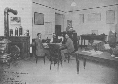
| In 1914, Pecos River water users complained about what they considered to be Federal mismanagement of the Carlsbad Project. Water user's meetings were often held at the district office located in downtown Carlsbad, pictured here in April 1914. — Southeastern New Mexico Historical Society, Carlsbad, New Mexico. |
A second study, with more significant implications, examined the Carlsbad Project the following year. This Local Cost Review Board was authorized by the Secretary of the Interior in January 1915, in response to local farmers' increasingly vocal claims of Reclamation Service inefficiencies and overcharges. The board was instructed to impartially review the Reclamation Service's expenditures on the Carlsbad Project, and determine whether the Federal charges that had been assessed to the project landowners were justified. The board consisted of three members: Scott Etter, representing the water users; D.W. Murphy, representing the Reclamation Service; and T.U. Taylor, a presumably neutral professional from the University of Texas faculty. The trio's fact-finding activities consisted largely of reviewing official documents and conducting public hearings at Carlsbad in April 1915. The Reclamation Service's annual Carlsbad Project report quietly noted that the hearings "produced some friction between Service officials and association officials." [17]
As might be expected, the board failed to reach a consensus in its conclusions. Etter and Taylor prepared a majority report, forcing Murphy to submit a supplemental minority report. The majority report was an emotional, scathing indictment of the U.S. Reclamation Service, reciting a litany of botched government decisions and foolish expenditures. The alleged poor management greatly escalated the project costs — costs which, under the terms of the Reclamation Act, the project farmers were required to repay through their annual assessments. Among the report's many complaints were allegations that the 1911 flood damage at Avalon was caused by a sleeping Reclamation Service watchman, and that the cylinder gates constructed in response to the flood were "elaborate," "costly," and "unnecessary." [18] The report recommended that the project landowners be relieved of repayment responsibility for many of these costs. The document further suggested that it was a violation of "law and equity or square dealing" to force the project farmers to pay for improvements that were owned not by them, but by the Federal government. [19] Taylor and Etter concluded by suggesting that the alleged cost excesses and the payments towards Federally-owned assets not be charged to the landowners. Doing so would reduce the total per-acre assessment by over one-half. The document dramatically concluded with the phrase, "GOD PITY THE WATER USER ON THE CARLSBAD PROJECT." [20]
Murphy's minority report was a careful attempt to discredit the majority report, point by point. He concluded that all of the Reclamation Service's charges to the project were fair and justified, and that Taylor and Etter were guilty of sloppy research and a predisposition towards the water users' claims. Etter and Taylor responded with a Supplemental Majority Report, which refuted the minority report; soon after, Murphy countered with a Supplemental Minority Report. It became obvious that the review board's intended goal of adjudicating the finances of the Carlsbad Project had collapsed into yet another barrage of accusations and conflict. [21]
Unfortunately for the Reclamation Service, the majority report's authors rapidly released their expose to the press, and their comments received wide circulation, both in New Mexico and in other western states. The report was also reprinted as a pamphlet, which was distributed among water users in a number of Reclamation Service projects. This resulted in substantially increased resentment towards a Reclamation Service that was already less than popular. (Although Taylor later removed some of the report's more emotional statements, he continued to steadfastly stand by its conclusions.) The following spring, after emotions had subsided somewhat, a Reclamation Service Central Board of Review examined the majority report and explicitly rejected most of its contentions, while praising the Reclamation Service and subtly criticizing its detractors. The central board concluded that the project's construction assessments should remain largely unchanged. [22]
The central board dealt with the issue of tide to the system's improvements by simply recommending that the entire project be turned over to local ownership and control as soon as possible. [23] The concept of a return to local ownership had been discussed before, and it was destined to surface again. The idea received support as early as 1914, when the water users association submitted a resolution to the Department of the Interior asking that they be given control of the project. The resolution seemed to draw little attention, presumably because many of the project's farmers were satisfied with the project's Federal management. Reportedly, the desire for local control was promulgated, at least in part, by owners of large tracts who were unhappy with the 160-acre restrictions embodied in the Reclamation Act. [24]
Although the graduated fee payment system adopted at the Carlsbad Project in 1912 had quieted some of the financial discord among project farmers, it was not seen as a perfect solution. The local farmers' recurring difficulty in meeting their construction assessments also mirrored serious problems inherent in most of the Reclamation Service's projects, and by 1914 Congress realized that a nationwide restructuring of the system was in order. The result was the Reclamation Extension Act, approved by Congress on August 13, 1914. The Act, recognizing that the huge expenses of Reclamation Service construction simply could not be repaid in ten years, doubled the allowable repayment period to twenty years. Locally, the Reclamation Service and Pecos Water Users Association wasted no time in urging local farmers to accept the terms of the Act, noting that their annual assessments would be greatly reduced by doing so. [25] Nearly all the Carlsbad Project irrigators apparently took advantage of the act. The lengthened repayment period eased the farmers' financial pressures, although their continuing difficulty is reflected in the passage of 1926 legislation (44 Stat. 649) which increased the allowable repayment period to forty years. [26]
The passage of the Reclamation Extension Act was one reflection of an increasing congressional awareness of major problems inherent in nearly all Reclamation Service projects. These problems included the financial hardships experienced by project farmers, the under-utilization of project waters, the inadequacy of some local soils, and occasional difficulties in contracting local landowners to use project water. In most Reclamation Service projects, the severity of these problems eventually resulted in huge financial write-offs by the government; difficulties at some Reclamation projects were so severe that their complete abandonment was seriously considered. In contrast, the Carlsbad Project exhibited most of these problems in only limited measure. Consequently, by the 1920s, comparative studies of western irrigation projects often pointed to Carlsbad as a relative example of Reclamation Service success. The 1927 volume Economics of Land Reclamation, for example, termed Carlsbad the second most successful of all Reclamation Service projects, based on land utilization. According to the book, this was because "the high prices of cotton have brought about a full utilization of the lands in spite of a somewhat uncertain water supply." [27]
Project Expansion and Refinement During the 1910s
The less restrictive repayment terms embodied in the Reclamation Extension Act presented the Carlsbad Project's managers with an opportunity to increase the total project budget and undertake additional rehabilitation work. The need for this work had been codified in the Reclamation Service's 1914 study of the project, and project administrators now saw the opportunity to accomplish some of the report's goals. Accordingly, by late 1914 the Reclamation Service had prepared an ambitious plan to line much of the project's main canal system with concrete to reduce seepage and increase the acreage served. The project would be partially financed by an additional $10.00 per acre assessment on existing Project lands. Under the new Federal regulations, this fee would be paid in installments after the current $45.00 per acre fee had been completely repaid. The new acreage to be added to the district was to be assessed a single construction fee of $60.00 per acre. This scheme was approved by the majority of the project's landowners, allowing the concrete lining work to begin during the winter of 1914-1915.
The canal lining project allowed the Reclamation Service to expand the area served by the 4,500 acres specified in the 1914 report. The expansion was announced by a public notice dated April 10, 1915, enumerating Reclamation Service plans prepared the preceding year and approved by the water users association. The lands eligible to be added were already within reach of the project's canal network, and substantial additional construction was not required. The lands admitted were placed under a variety of fee payment schedules, depending on the status of the land's water rights and the wishes of its owners. Landowners who chose to take advantage of the Reclamation Extension Act were offered the most lenient terms: a graduated repayment plan stretching over twenty years. [28] The new fee schedules implemented in 1915 further complicated the repayment system; there were now perhaps half a dozen repayment schedules in place on project lands, varying substantially in duration, scope, and amount.
|
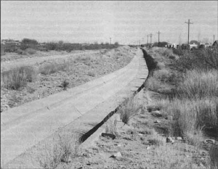
| An additional user fee of $10 per acre allowed the Reclamation Service to line many of the earthen laterals with concrete during the winter of 1914-1915. East Side Canal, view looking east. — Fred Quivik, February 1990. |
As the 1915 project expansion got underway, the Reclamation Service once again evaluated the possibilities of larger-scale project growth, and once again the concept centered around the oft-discussed Reservoir No. 3. Although Willis Lee's 1905 geologic examination of the reservoir site had resulted in an unfavorable recommendation, a similar study in 1911 by geologist G.B. Richardson presented diametrically opposed conclusions. Richardson's study assumed that Reservoir No. 3 would serve as a replacement for McMillan; he stated that the new site was "unusually good for the Pecos Valley... much better than that of Lake McMillan." [29] Although Richardson's report received little response in 1911, it somehow surfaced in 1915 as support for a much larger expansion of the Carlsbad Project. The 1915 Federal proposal involved the construction of Reservoir No. 3 as a supplement (rather than replacement) for McMilan, and using the impounded water to irrigate vast tracts of land west of the existing project. This would be accomplished by constructing a new concrete-lined West Side Canal, providing access to some 19,000 acres of irrigable land. The report also suggested the construction of a High Line Canal, which would utilize water pumped from the West Side Canal and serve an additional 7,500 acres. Electric-generating facilities would also be provided at the new dam. [30] The proposal failed to result in Federal action, however, and a follow-up query by the Carlsbad Commercial Club produced the response that "conditions have been found to be such as not to warrant an effort to get through general legislation upon this subject." [31]
Meanwhile, though, the project was visited by another of the Pecos River's recurring flash floods, and the very safety of the project's physical plant was called into question. The floodwaters pounded McMillan Dam for three days in mid-April 1915, completely submerging the facility's east embankment. A small leak appeared in the main dam at the height of the flood, and for a time the dam's collapse seemed imminent. Many Carlsbad residents quickly scurried for higher ground on hearing the news. A heroic sandbagging effort by Geological Survey personnel at the scene stemmed the leak after several hours of uncertainty, and "the old pile of earth and rock" was saved, only slightly damaged. [32] Simultaneously, the high water caused varying levels of damage to portions of the project canals and to the concrete siphon beneath Dark Canyon.
In reviewing McMillan's flood damage E.H. Baldwin, the local supervising engineer, bluntly reported that "The dam is not safe," and remarked that "There is no good reason for the dam being almost intact to-day, for it is only in defiance of all laws of force that it is still standing." [33] He recommended that a board of engineers convene immediately to consider reinforcing the structure. The requested board convened that June, and strongly recommended that McMillan be provided with a concrete "siphon or gate controlled spillway" large enough to accommodate the most severe expected floods. [34]
Throughout most of 1915 and into 1916, Reclamation Service engineers undertook extensive design studies aimed at providing the additional spillway capacity called for in the board of engineers report. Test pits sunk into the McMillan Dam indicated the presence of cracks and holes serious enough to require immediate attention. In response, a trench averaging 12 feet deep was dug across the top of the dam and filled with puddled clay and gravel. As the design studies for the spillways dragged on, Hill urged the Reclamation Service office in Denver to begin work as rapidly as possible "in order to save the McMillan reservoir and hence the Carlsbad Project." [35] Plans and cost estimates were completed at each of four potential spillway locations for low head radial gates, high head radial gates, roller gates, and a spillway siphon. Of the alternatives, the least expensive solution was for placing a controlled spillway in or near the dam. A board of engineers finally met at McMillan in May 1916 to consider all of the proposed alternatives. After test borings in the foundation of the dam, the board was adverse to any alternative that would dump water near the toe of the dam. The fact that McMillan's capacity was rapidly diminishing due to silting was also a factor. The reservoir's apparently short lifespan caused the board to question the prudence of spending large sums of money on an elaborate solution "if any other scheme can be devised, which during the next ten years may give at least reasonable protection." [36] They proposed simply widening two of the existing spillways and providing low earthen dikes across their openings that would wash out during floods. [37]
The spillways finally constructed were more permanent than those proposed by the board. Spillway No. 1 was located in a saddle approximately 2,500 feet northwest of McMillan Dam. The spillway consists of a 1400-foot-long concrete weir placed between concrete abutments. The weir rises only a few inches above the surrounding ground level, which in places was raised to the appropriate elevation with rock riprap. Water passing over the spillway enters a channel and discharges into the Pecos River about one-half mile below McMillan Dam. To protect the Atchison, Topeka, and Santa Fe's adjacent railroad bed, a 3000-foot-long rock-filled dike with an earth-fill face was constructed. [38] Engineers had to give special consideration to a portion of the lower end of the dike that was subject to high water velocities; here, the Reclamation Service developed an innovative wire-bag riprap. Use of the large wire bags had two advantages: the 6-inch mesh of the bags allowed the use of rock that was otherwise too small to be used in traditional riprapping and labor was reduced by the ability to fill the bags directly from wagons. [39]

|
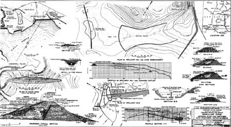
| After a Pecos River flood in 1915, one reclamation engineer reported that "there is no good reason for the [McMillan] dam being almost intact to-day, for it is only in defiance of all laws of force that it is still standing." The Reclamation Service immediately began preparing plans to provide additional spillways for McMillan Dam. — Denver Branch, National Archives, Denver, Colorado; June 29, 1916. |
The most impressive new structure, however, was Spillway No. 2. In plan, the mouth or crest of the spillway opens from the north. The spillway then swings around to discharge water in a west-southwesterly direction. The mouth of the spillway is 350 feet wide. The spillway was originally 740 feet long, although a relocation of the Santa Fe Railway through the site in the 1980s reduced the spillway's length to 487 feet. The spillway has a concrete floor with concrete sidewalls rising 8 feet and sloping outward. A 5 to 6 foot-high training wall through a portion of the center of the structure directs the flow of the water around the curve to the throat where the spillway straightens out. [40]
|
| Spillway Number 1 consisted of a 1400-foot-long concrete weir, constructed northwest of McMillan Dam. — Bureau of Reclamation, Salt Lake City; July 19, 1937 |
Work on the new McMillan spillways began in the fall of 1916. With the approval of the water users association, the new spillways were funded with a portion of the increased construction assessment approved in 1914. Work was performed under Reclamation Service supervision, and was officially completed on May 26, 1917. [41] The remaining flood damage had been repaired during 1916. This work included extending the Dark Canyon siphon by some 200 feet to prevent further erosion damage to the structure. Meanwhile, the Pecos River's erratic nature continued to manifest itself, with additional flooding in August 1916, followed by a substantial water shortage in 1917. [42]
The 1917 water shortage caused the Reclamation Service to cast a critical eye towards upstream users of Pecos River water. This scrutiny led to a Federal lawsuit against upstream operators of irrigation pumping plants. [43]
The impact of the 1917 drought was further exacerbated by the rapidly decreasing storage capacity of McMillan Reservoir. This was along-standing project concern, stemming largely from the substantial amount of silt the Pecos River annually deposited in the reservoir. The problem had been recognized early in McMillan's history, and seemed destined to rapidly destroy the dam's effectiveness unless corrective measures were taken. By 1916, the Reclamation Service estimated that some 3,900,000 cubic yards of silt already reposed in McMillan Reservoir, and that within twenty years the reservoir would be virtually filled with silt. Several possible solutions to the problem were suggested and rejected: dredging the reservoir floor was dismissed as technologically impractical, and periodically raising the dam height would become progressively more expensive over the years. It was concluded, then, that the project's health required that "storage must be found for about 50,000 acre-feet free from the evil of silting." For some observers, at least, finding a new reservoir site somewhere upstream from the community of Fort Sumner seemed to be the way to achieve that goal.
Continued Controversy The Post-World War I Years
The long-discussed concept of additional upstream storage for the Carlsbad Project was destined to come to fruition, but not immediately. During the 1910s and 1920s, the Reclamation Service continued to study possible project expansion; these studies looked both at increasing the farmland served by the project and providing a more stable water supply for the existing acreage. Both of these goals depended on the development of increased reservoir storage capacity, and various Reclamation Service reports examined three possible methods for achieving this end: building the long-discussed Reservoir No. 3, raising Avalon Dam, and constructing a reservoir upstream near Fort Sumner. The Fort Sumner area already hosted a small, private diversion dam and irrigation canal; Reclamation Service proposals contemplated the Federal takeover and enlargement of the private canal as part of a new storage dam project.
The Reclamation Service's continued expansion studies were partially the result of enthusiastic lobbying by the Pecos Water Users Association and its new president, none other than Francis G. Tracy. Under Tracy's leadership, the water users went beyond their earlier efforts by agreeing to financially support local Reclamation Service study projects. This support, raised by subscription among the water users membership, was contractually specified at $10,000, although the local fund raising reportedly fell substantially short. [45] Tracy was presumably influential in instituting this fund-raising effort, seeing it as yet another chance to provide irrigation to additional valley lands. Two areas were being considered for possible addition to the project: large tracts in the Malaga region south of the existing canals (where Tracy may still have held a financial interest), and a district to the west of the project, which had been a part of the earlier High Line canal proposal. Federal studies seemed to prefer the latter area, which would have been serviced by a new canal network originating at Reservoir No. 3. [46]
Tracy and the water users association generally favored the Reservoir No. 3 proposal, and their financial contributions were originally intended for studies of that site and associated canal expansion. The Reclamation Service, however, remained skeptical of Reservoir No. 3, repeatedly noting the "cavernous limestone underlying the dam site and gypsum outcrops near the center of the reservoir." [47] The Service seemed to look more favorably on constructing a dam at the Fort Sumner site, which seemed to display none of the geological obstacles of Reservoir No. 3. In 1922, the water users agreed to allow a portion of their contributions to fund surveys of the Fort Sumner site. [48]
The Reclamation Service completed a substantial series of geological and reclamation studies at both Pecos River sites between 1920 and 1923. This work culminated in a voluminous May 1923 summary report by Ferd Bonstedt and E.B. Debler, two Reclamation Service engineers. Bonstedt and Debler's document evaluated reservoir and irrigation problems and opportunities throughout the Pecos River basin. While the Bonstedt and Debler report did not provide explicit recommendations for future development, the pair looked favorably on constructing the Fort Sumner reservoir to provide water for both Carlsbad and Fort Sumner farmers. Their conclusions generated substantial correspondence within the Department of the Interior, but failed to create an immediate Federal resolve to proceed with new construction. [49]
Despite the unresolved issues relating to the Carlsbad Project's water supply, a small amount of additional acreage was added to the Project in 1919. This "Third Unit," comprising 1,131 acres, brought the total farmland served to 25,000 acres. Reportedly, the added lands were expected to be populated in part by returning soldiers from World War I.
Although Tracy and the water users association displayed a surprisingly cooperative attitude by agreeing to help fund the Reservoir No. 3 studies, their combative spirit remained active on other fronts. This was demonstrated in 1919 when the water users took up the cause of ending Reclamation Service liens on project farmlands. The government imposed mandatory liens on the Carlsbad Project's farmland as a condition of receiving water; the liens were intended to ensure repayment of the Project construction assessments. The government held two liens on each of the project's farms: the first lien represented the amount of land an owner had subscribed to the project, while the second was placed when the owner filed for a record of water rights. According to the water users, the government liens "made it impossible for us to borrow any money elsewhere upon our equity (if indeed... we have any equity) in the lands we occupy and presume to own." [50] In particular, the settlers were unable to obtain loans from Federal Farm Loan Banks, which required a first mortgage as security. Although some insurance companies recognized an equity above these liens and did provide loans to farmers, they did so at a less favorable interest rate.
This situation, which the water users characterized as "serfdom under a department of the United States," allegedly caused the farmers substantial hardship, and in April 1919 the water users began a campaign to have the property liens removed. [51] The centerpiece of their effort was a preprinted letter sent to various senators and representatives claiming that the liens made their water rights "a perpetual liability instead of an ever growing asset," and that the problem was exacerbated by the government's exorbitant late payment fees. [52] An identical letter was sent to New Mexico's governor, who also began writing sympathetic letters to Washington. Secretary of the Interior Franklin Lane was unmoved, however, pointing out that the liens were mandated by the Reclamation Act and suggesting that the water users could operate the system themselves if they were unhappy with Federal control. [53] Lane's suggestion presumably involved the organization of a local irrigation district, which would allow the government to remove the first liens and ease the borrowing process for the farmers. Water users at other Reclamation Service projects had already taken this step, and it is unknown why the farmers at Carlsbad failed to do so.
Although the water users recurring complaints to the government generally seemed to fall on deaf ears, actions such as the 1915 Board of Cost Review served to indicate that the Reclamation Service was at least somewhat concerned about the efficiency of the Carlsbad Project. This concern was further demonstrated in 1923 when the Department of the Interior dispatched a special investigator to Carlsbad to examine the project's operating and maintenance costs. This man, C.R. Trowbridge, independently expanded his inquiry to encompass virtually every aspect of the project's operation. His final, 66-page report provided some 44 recommendations for improving the project's management and eliminating allegedly inappropriate or illegal practices by Project staff. Trowbridge's exposé uncovered supposed problems in virtually every sector of the project's operation, and included a recommendation that L.E. Foster, the project Manager, be fired. The most serious charges revealed possible conflicts of interest involving Foster and other project employees, some of whom were operating farms on land served by Federal water. Other problems were more minor, such as Trowbridge's observation that a lack of spittoons at the Carlsbad Project headquarters forced employees to expectorate out an office window. [54] It is unknown how aggressively the Reclamation Service responded to Trowbridge's report, but Foster successfully weathered Trowbridge's attack and remained a this position at Carlsbad until 1945. [55]
The continuing issue of excess individual land holdings within the project was one of the problems addressed by Trowbridge. In spite of the long-standing legal prohibition against ownership of more that 160 acres of land in a reclamation district, Trowbridge identified a total of 17 landowners who each owned or controlled over 200 acres within the Carlsbad Project. Among them, this group held a total of 9,413 acres of irrigable land, more than one-third of the project's total area. [56] In a probable reaction to Trowbridge's report, Foster received instructions from Washington to begin a crackdown on excess landowners, most of whom had been easily circumventing the Federal acreage restrictions for years. In response, Foster complained that the rule was difficult to enforce, stating:
In a number of cases where the title is shown on the County records in one name, we have evidence that the title really rests in another person who is holding land in excess of that permitted by law. Where an excess land owner disposes of land held in excess of the law, it has been the custom heretofore on this project for such owner to use the names of "dummy" owners. This means that a certain amount of land is deeded to someone else by Warranty or Quit-Claim Deed, such deed being recorded on the county records. In such cases the land is deeded back by the "dummy" owner to the real owner and the returned deed is not recorded. [57]
The continuing 1920s studies aimed at increasing water storage for the Carlsbad Project were perhaps a cause for optimism among the project's landowners, but they were simultaneously an equally powerful source of concern for other groups who also relied on Pecos River water for their livelihood. The potential for disputes over water rights on the Pecos came to the surface in 1923, as the Reclamation Service began active study of a reservoir site at Red Bluff, on the Texas end of the Pecos Basin. This, and other proposed Pecos River reclamation projects in both Texas and New Mexico, demonstrated the need for a formal agreement allocating the basin's water supply. Representatives of the two states began work on such an agreement in 1923, and by February 1925 a negotiated "Pecos River Compact" was submitted to the two states' legislatures for approval. New Mexico's legislature ratified the compact, but it was vetoed by the governor following protests by the Pecos Water Users Association. Although the compact continued to be discussed until at least 1933, it was never fully accepted by both states, and it remained for a future generation to negotiate a final allocation of Pecos River water. [58]
By the late 1920s, the proposed Fort Sumner project began to receive less and less Federal attention. In its place appeared various schemes to raise Avalon Dam to increase the reservoir's storage capacity. This proposal attracted considerable Federal attention between 1927 and 1930, generating numerous Bureau of Reclamation reports. The reasons for this shift in attention are speculative, although it is likely that pressure from the water users association was largely responsible. In May 1926, the water users formalized a contract with the Bureau of Reclamation authorizing the first of the Avalon studies, and the group displayed vocal support for the proposal over the next several years. They were perhaps distrustful of moving the Carlsbad Project's water storage to far-away Fort Sumner; at any rate, they consistently maintained that "the annual run-off of the Pecos River at Avalon is much more than ample for all needs for [the] Carlsbad Project." [59] The Bureau of Reclamation also professed interest in the idea, but in part for a different reason. Government reports indicated that Avalon Dam, while a basically safe structure, would possibly collapse if McMillan failed and sent its waters towards Avalon. If both the project's dams were to fail, the ensuing flooding would be both devastating and deadly to the townsite of Carlsbad. Raising Avalon Dam would reduce the likelihood of such a disaster.
|
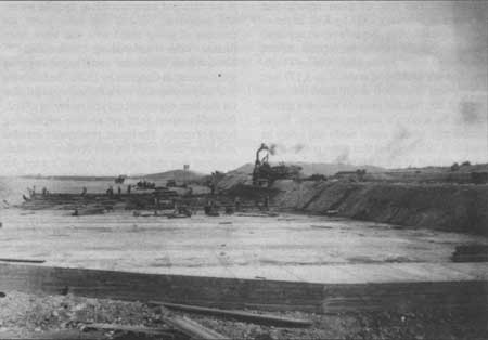
| Construction of a second concrete spillway (Number 2) began in the fall of 1916, and was completed the following year. In plan, the mouth of Spillway Number 1 bends west to discharge river runoff. — Carlsbad Irrigation District, Carlsbad, New Mexico; ca. 1917. |
Much of the official study centered on the unknown efficacy of an enlarged Avalon Reservoir. Although the existing Avalon Dam and Reservoir were relatively leak-free, there was concern that a higher water level would penetrate some of the same gypsum formations that made Reservoir No. 3 such an uncertain proposition. The first of these reports was completed in February 1927 by Kirk Bryan of the Geological Survey. Bryan's report appeared to indicate that the expansion proposal showed at least some merit. At the time, Avalon's high-water line was established at elevation 3,177 feet; the proposed expansion would raise the water level to 3,200 feet and provide at least a sixfold increase in Avalon's storage capacity. Bryan believed that Avalon could easily and safely be raised to 3,192 feet, but that some potential for leakage existed at the 3,200 foot level. [61]
At least five additional Federal reports on the subject were filed in the ensuing two years, each coming to a slightly different conclusion. The majority of the bureau's engineers seemed to feel that, while the risk of reservoir leakage was present, the potential benefits of a larger reservoir outweighed the risks. (Most, however, suggested that a water level higher than 3,192 feet would have a relatively high potential for seepage.) In contrast, Bryan became less and less comfortable with the proposal as his local studies continued. [62]
The water users association quickly began utilizing these generally favorable reports in an aggressive campaign to win Federal funding for enlarging Avalon. These efforts were well underway by November 1927, when the water users issued a resolution requesting that Congress approve emergency funding for the project, which they estimated would cost $900,000. Such action, according to the water users, was the only way to counteract "the crop losses we have already suffered, and are facing every year until this storage is provided." [63]
The water users continued to lobby for the reservoir's expansion through 1929, although Bureau of Reclamation support for the proposal was lukewarm at best. A.F. Walter, the Bureau of Reclamation's Chief Engineer, feared that the bureau would be left holding the financial bag if the enlarged reservoir failed to hold water, and suggested "that if the water users are desirous of going ahead with this work, they finance the undertaking themselves." [64] Nevertheless, the water users began enjoying some success in Congress by 1928. The following year they managed to win a Federal appropriation for the dam, dependent only on receiving a final, favorable report from yet another engineering board of review. The report, presumably intended to be the final word on the Avalon proposal, admitted that the Carlsbad Project's need for additional water was "obvious and impressive." [65] The board claimed to have made "an earnest effort to find a sound [geological] basis" for increasing Avalon's storage capacity, but concluded that the physical conditions at the site rendered the proposal completely unpractical. [66]
Despite the water users pleas, the board's report effectively killed the Avalon proposal, at least for the time being. In November 1929, the bureau informed the water users that "It is believed under the circumstances [that the water users] must proceed along such lines as their interests require and with their own initiative." [67] Tracy expressed the water users' substantial frustration with the situation, complaining that the negative reports contained "fundamental errors" which remained even though they had been "exploded by data and measurements of the Bureau of Reclamation." Tracy also stated that the entire deadlock had come about simply because of a faulty Federal decision not to construct Reservoir No. 3. [68] Nevertheless, he stated that "I feel that the dam will be raised some day. We could finance it ourselves if it were not for the $800,000 Federal farm loans upon the project lands which effectively block us from any bond issue." [69] Meanwhile, though, the Carlsbad Project remained without an adequate reserve water supply.
Endnotes
1. L.E. Foster to the Water Users, Carlsbad Project, August 29, 1914, RG 115, General Correspondence Files, Box 282, File 85, National Archives, Denver Branch, Denver, Colorado.
2. "Eddy County, New Mexico," ([Santa Fe:] Bureau of Immigration of New Mexico, 1908).
4. Etter, "Carlsbad Project Makes Bid for Farmers," 121.
5. L.E. Foster to the Commissioner (with attachments), November 11, 1924, RG 115, General Correspondence Files, Box 282, File 85, National Archives, Denver Branch, Denver, Colorado.
6. P.J. McShane to W.M. Reed, October 30, 1911, RG 115, Entry 3, Box 441, File 466, National Archives, Washington, D.C.
8. The telegram is quoted in A.P. Davis to F.H. Newell, November 4, 1911, ibid.
9. W.M. Reed to A.P. Davis, November 18, 1911, ibid.
10. C.G. Smith to the Comptroller, U.S. Reclamation Service, August 8, 1915, RG 115, Entry 3, Box 438, File 338-Al, National Archives, Washington, D.C.
11. Francis G. Tracy to Samuel Adams, February 1, 1912, RG 115, Entry 3, Box 441, File 466, National Archives, Washington, D.C.
12. W.M. Reed to the Director, U.S. Reclamation Service, February 12, 1912, ibid.
13. Louis Hill to the Director, U.S. Reclamation Service, April 17, 1913, RG 115, Entry 3, Box 449, File 875, National Archives, Washington, D.C.
14. Ibid.; A.P. Davis to Louis Hill, May 19, 1913, RG 115, Entry 3, Box 449, File 875, National Archives, Washington, D.C.
15. Carlsbad Commercial Club to Robert Ervien, State Land Commissioner, February 17, 1914, RG 115, Entry 3, Box 441, File 466, National Archives, Washington, D.C.
16. "Carlsbad Project, New Mexico: Project History [1914]."
17. "Carlsbad Project, New Mexico: Project History [1915]."
18. T.Y. Taylor and Scott Etter to Franklin K. Lane, June 17, 1915, RG 115, Entry 4, Box 10, File 262-D3, National Archives, Washington, D.C.
19. "Carlsbad Project, New Mexico: Project History [1915]." Portions of the local board's report, and the rebuttal by the Reclamation Service, are in "Report of the Central Board of Review on the Carlsbad Project, New Mexico," reprinted in Reclamation Record, July 1916, 298-308.
20. "Report of the Central Board of Review."
21. All of the documents maybe found in RG 115, Entry 4, Box 10, File 262-D3, National Archives, Washington, D.C.
22. "Report of the Central Board of Review."
24. M.L. Muggeridge to F.K. Lane, April 13, 1914, RG 115, Entry 3, Box 449, File 1158, National Archives, Washington, D.C.
25. W.A. Ryan, Comptroller, U.S.G.S. to W.B. Wilson, Pecos Water Users' Association, October 17, 1914 (with attachments), RG 115, Entry 3, Box 440, File 338-AS, National Archives, Washington, D.C.
26. Robinson, Water for the West, 42-44, 58; "Preliminary Inventory of the Records of the Bureau of Reclamation," 1.
27. Ray P. Teele, The Economics of Land Reclamation in the United States (Chicago and New York: A.W. Shaw Company, 1927), 187. Teele's book ranks only the Salt River Project in Arizona as being more successful than Carlsbad.
28. A.P. Davis to the Secretary of the Interior (with attachment), April 10, 1915, RG 115, Entry 3, Box 438, File 338-A, National Archives, Washington, D.C.
29. G.B. Richardson, "Notes on Proposed Reservoir Site No. 3, Carlsbad Project, New Mexico." RG 115, Entry 3, Box 443, File 651, National Archives, Washington, D.C.
30. "Report on the Proposed West Side Addition to the Carlsbad Project, New Mexico: March 2, 1915" ([Washington]: Department of the Interior, U.S. Reclamation Service), RG 115, Entry 3, Box 442, File 351, National Archives, Washington, D.C.
31. A.A. Jones, Department of the Interior, to Frank H. Richards, Carlsbad Commercial Club, April 13, 1916, RG 115, Entry 3, Box 441, File 466, National Archives, Washington, D.C.
32. "McMillan Stands the Test," The Carlsbad Argus, April 23, 1915.
33. E.H. Baldwin to the Director and Chief Engineer, U.S. Reclamation Service, April 23, 1915, RG 115, Entry 3, Box 442, File 351, National Archives, Washington, D.C.
34. D.C. Henny, et. al. to the Reclamation Commission, U.S. Reclamation Service, June 11, 1915, ibid.
35. Correspondence regarding the design of the spillways at McMillan, ibid.
38. Department of the Interior, Bureau of Reclamation, "McMillan Dam: General Plan and Sections with Proposed Improvements," 1937, Engineering drawing number 5-D-489 from aperture card, Bureau of Reclamation, Salt Lake City, Utah.
39. L.E. Foster, "Wire-bag Method of Riprapping Embankment, Lake McMillan, Carlsbad Project," Reclamation Record 10 (January 1919): 33-34.
40. Department of the Interior, Reclamation Service,"Detail Construction Spillway No. 2," 1917, Engineering drawing from aperture card, Bureau of Reclamation, Salt Lake City, Utah.
41. "Carlsbad Project, New Mexico: Project History [1917]."
42. D.C. Henny to the Chief of Construction, U.S. Reclamation Service, August 23, 1916; L.E. Foster to the Directory, U.S. Reclamation Service, October 5, 1917, RG 115, Entry 3, Box 442, File 651, National Archives, Washington, D.C.
43. "Carlsbad Project, New Mexico: Project History [1917]."
44. Department of the Interior, United States Reclamation Service, "Report of Board of Engineers, May 3, 1916: Water Supply and Storage — Carlsbad Project," RG 115, Entry 3, Box 442, File 351, National Archives, Washington, D.C.
45. Director, United States Reclamation Service to the Chief Engineer, United States Reclamation Service, March 25, 1921, RG 115, Entry 7, Box 451, File 301, National Archives, Washington, D.C.
46. Chief Engineer, U.S. Reclamation Service, to the Commissioner, U.S. Reclamation Service, August 8, 1923, RG 115, Entry 7, Box 451, File 351, National Archives, Washington, D.C.
47. Taylor to the Director, U.S. Reclamation Service, June 4, 1923, RG 115, Entry 7, Box 451, File 301, National Archives, Washington, D.C.
49. Ferd Bonstedt and E.B. Debler, "Report on Investigations: Pecos River and Carlsbad Project Extensions in New Mexico, May, 1923," ibid.
50. Pecos Water Users' Association to "Mr. Congressman or Senator," April 5, 1919, RG 115, Entry 3, Box 438, File 338-Al, National Archives, Washington, D.C.
53. Franklin K. Lane, Secretary of the Interior to O.A. Larrazolo, Governor of New Mexico, May 29, 1919, ibid.
54. C.R. Trowbridge, "Report on Inspection of Carlsbad Project — Reclamation Service," RG 115, Entry 7, Box 445, File 105.21, National Archives, Washington, D.C.
55. "Carlsbad Project, New Mexico: Project History [1945]."
56. C.R. Trowbridge, "Report on Inspection of Carlsbad Project — Reclamation Service," RG 115, Entry 7, Box 445, File 105.21, National Archives, Washington, D.C.
57. L.E. Foster to the Commissioner, Bureau of Reclamation, October 20, 1923, RG 115, Box 282, File 85, National Archives, Denver, Colorado.
58. Clark, Water in New Mexico, 229.
59. L.E. Foster to the Commissioner, Bureau of Reclamation, November 3, 1927 (with attachments), RG 115, Entry 7, Box 451, File 301, National Archives, Washington, D.C.
60. C.P. Gross, Army Corps of Engineers, to the Secretary of the Interior, October 30, 1928, RG 115, Entry 7, Box 452, File 301.1, National Archives, Washington, D.C.
61. Kirk Bryan, "Geology of Avalon Reservoir, Carlsbad Irrigation Project, New Mexico, With Respect to Proposed Increase in Height of the Dam," typescript, United States Geological Survey, February, 1927, RG 115, Entry 7, Box 453, File 301.12, National Archives, Washington, D.C.
62. Commissioner, Bureau of Reclamation to Sam G. Bratton, United States Senate, February 23, 1929, RG 115, Entry 7, Box 452, File 301.1, National Archives, Washington, D.C.
63. L.E. Foster to the Commissioner, Bureau of Reclamation (with attachment), November 3, 1927, RG 115, Entry 7, Box 451, File 301, National Archives, Washington, D.C.
64. A.F. Walter, Chief Engineer, to the Commissioner, Bureau of Reclamation, March 1, 1928, ibid.
65. O.E. Meinser, et. al. to the Director, U.S. Geological Survey, September 10, 1929, ibid.
67. Francis G. Tracy to George B. Harrison, December 24, 1929, New Mexico State Records Center and Archives, Santa Fe.
69. Francis G. Tracy to Herbert W. Yeo, New Mexico State Engineer, January 9, 1930, files of the Office of the State Engineer, Santa Fe, New Mexico.
| <<< Previous | <<< Contents>>> | Next >>> |
rmr/0/chap8.htm
Last Updated: 01-Feb-2008