|
FIRE ISLAND
Ecological Studies of the Sunken Forest, Fire Island National Seashore, New York NPS Scientific Monograph No. 7 |

|
CHAPTER 1:
GEOLOGY AND CLIMATE OF FIRE ISLAND
Methods
To observe fluctuations in the ground water-table level in the Sunken Forest, a polyethylene-lined well was sunk to a depth of 35 cm. The top of the well was 2.0 m above mean sea level. Measurements of water-table elevation were made at roughly weekly intervals between 16 November 1968 and 2 October 1969.
Air temperature, relative humidity, and precipitation data for the period October 1968 to October 1969 were collected at a meteorological station set up at the National Park Service Sailors Haven Station, 0.5 km east of the Sunken Forest. Temperature and humidity were recorded on a hygrothermograph enclosed in a standard weather shelter. Precipitation was collected and measured in a standard U.S. Weather Bureau 8-inch rain gauge. Precipitation distribution, wind speed, and wind direction data were obtained from the U.S. Coast Guard Fire Island Station 9 km west of the Sunken Forest.
Geology and Hydrology
The geologic history of Fire Island is closely related to the glacial history of Long Island. During the Wisconsin Stage of the Pleistocene Epoch, the ice sheet stagnated at what is presently southern Long Island, forming the Ronkonkoma Moraine (Fig. 1) (Strahler 1966; Fuller 1914). Sediments carried by meltwater from the Ronkonkoma Moraine were sorted, the finest silt and clay material being deposited in the ocean, then about 130 m lower than at present (Strahler 1966; Milliman and Emery 1968). The coarser sediments were deposited nearer the terminal moraine. As the ice receded, it again stagnated at the present north shore of Long Island, forming the Harbor Hill Moraine (Fuller 1914). With rising sea levels, the glacially-derived sediments were subjected to further segregation and chemical alteration by sea water. The upper Pleistocene and Recent deposits in the vicinity of the Sunken Forest extend to a depth of 37 m; the surface 8 m of this deposit is composed of well sorted, fine and medium sands, overlaying coarse sands, and gravel (Fig. 2). Mineralogic analysis of sands in the Sunken Forest indicate 98% of the sediment is quartz sand, the remainder being predominantly magnitite, garnet, and tourmaline (Cowan pers. comm.). No feldspars or micas were found in the Sunken Forest sands.

|
| Fig. 1. Long Island and associated geologic features (after Cohen et al. 1968). (click on image for an enlargement in a new window) |

|
| Fig. 2. Fire Island stratigraphy well S30550 Sailors Haven (from USGS unpubl. data). |
The formation of barrier islands is a subject of some controversy. Based on nearshore bottom profile structure, Johnson (1919) supported the deBeaumont theory of barrier-island formation by emergent sand bars and concomitantly rejected the Gilbert theory of formation by longshore currents producing sand spits. The general absence of marine sediments in the bays and lagoons associated with the barrier islands in the southern United States has led Hoyt (1967, 1968) to theorize that barrier islands are the result of submergent rather than emergent shorelines. According to Hoyt, the dunes and other topographic features of the barrier islands were once mainland features. With the subsidence of the coastline, sea water filled in behind the dune ridges, creating the bays between the barrier island and the mainland shore.
It is beyond the scope of this study to determine the processes leading to the formation of Fire Island; however, it is clearly evident that both longshore and on-off shore currents are active agents in the modification of the present shoreline. Under the influence of longshore currents, which are predominantly from the east to west, Fire Island has been extending to the west at a rate of 66 m/year (Fig. 3) (U.S. Army Corps of Engineers 1960). This westward extension of Fire Island represents the transport of about 410,000 m3 of sediment per year (Taney 1961a).

|
| Fig. 3. Fire Island inlet 1834-1938 (after Andrews 1938). |
Erosion at the headlands of Long Island near Montauk Point accounts for only 22% of the sediments carried in the longshore currents (Taney 1961b). While headland erosion may be the major source of new sediments for Fire Island, most of the littoral sediments are probably from wave erosion of the beaches (Krinsley et al. 1964; Taney 1961a, b).
In the 121 years between 1835 and 1956, the shoreline changes on the Fire Island beach have varied between net additions of 3.3 m/year and net erosion of 1.3 m/year, depending upon location (Taney 1961b). In the area of the Sunken Forest during this period the shoreline has receded at an average rate of 0.8 m/year, compared to the average addition of 0.67 m/year for the island as a whole (Taney 1961b). Between 1940 and 1956, and during the period the present study was conducted, there was net erosion at nearly all locations on Fire Island (Taney 1961b). The beach erosion is the result of annual cycles in which sediments are added to the beach between May and August but are removed in greater amounts between September and April (U.S. Army Corps of Engineers 1960).
The usual topographic profile of the barrier island is a flat beach adjacent to the ocean, a primary dune ridge, an interdune swale, a secondary dune ridge, and a bay shore (Oosting 1954). In the Sunken Forest area of Fire Island, a maritime forest occupies the area immediately leeward of the secondary dune, and a salt marsh community is situated along the bay shore (Fig. 4).

|
| Fig. 4. Fire Island transect. |
The development of the characteristic barrier beach topography of dunes and swales is the result of plants acting as geomorphic agents (Free 1911; Cowles 1899; Olson 1958a, b). The critical wind speed for the transport of sand grains is about 4 m/sec at the ground surface (Olson 1958a). When winds of this speed or greater encounter the barrier-island vegetation, they may be locally slowed and deposition of sand grains may occur around the bases of the plants. The pioneer dune plants such as Ammophila breviligulata (beach grass)1 exhibit growth in response to this periodic burial (Olson 1958b). As this process is repeated, the height of the dunes increases probably up to an equilibrium height dependent upon the characteristics of the sand, the intensity of winds, the biologic limits of the vegetation, and the frequency of storms.
1Nomenclature follows Fernald, M. L. 1950 Gray's Manual of Botany, 8th edition for northern species and Small, J. K. 1933 Manual of the Southeastern Flora for southern species.
The soil temperature relations are largely influenced by shading effects of the plant cover. Due to the large pore space of dune soils, there is relatively little heat transfer to or from the subsurface layers, even though the surface-soil temperature wave may have a 30°C amplitude (Salisbury 1934). The rapid night-time cooling of the surface soil favors the formation of internal dew within the highly porous soil (Olsson Seffer 1909b; Boyko 1966).
Another consequence of the porous structure of the soil is the low capillary transfer of moisture from the subsurface soil through the dryer surface layers (Salisbury 1952; Free 1911). As a result, the moisture conditions of the subsurface soil layers are generally considered to be favorable for plant growth at all times (Chapman 1964; Salisbury 1952).
The sole source of fresh water on the barrier island is precipitation. The movement of fresh water in dune soils is rapid and predominantly downward (Salisbury 1952; Olsson-Seffer 1909b). Due to the rapid movement of fresh water through the dune soil, the ground water and soils of barrier islands have relatively low chloride concentrations, ranging between 0.03 and 0.003% of the soil weight (Kearney 1904; Kelly 1925).
The highly permeable soils and proximity to sea water produce a distinctive hydrological situation described by the Gyben-Herzberg principle (Crandell 1962; Harris 1967). Since fresh water has a specific gravity less than sea water, the structure of the barrier-island ground water system is a lens of fresh water floating on top of the salt water (Fig. 5). The theoretical depth of the fresh water lens below sea level is approximately 40 times the height of the water table above sea level (Crandell 1962).

|
| Fig. 5. Barrier beach hydrology (after Crandell 1962). |
The water table, as observed in the well in the Sunken Forest, fluctuated between 170 and 208 cm above mean sea level (Fig. 6). Therefore, theoretically the fresh-water lens should extend downward throughout the Pleistocene and Recent deposits (37 m depth). The fluctuations in the water table in the Sunken Forest appear to be strongly influenced by the amounts and periodicity of precipitation inputs. Ocean tides, evapotranspiration losses, and barometric pressure also undoubtedly influence the elevation of the water table (Hill and Hanley 1914; Crandell 1962; Perlmutter and DeLuca 1963; Fox and Davis 1971).

|
| Fig. 6. Precipitation and water table relations. Arrows mark days on which precipitation occurred. Solid line indicates millimeter precipitation per day for the collection period. Asterisk indicates the water table elevation on given days. |
Fluctuation of the water table leads to a diffusion zone rather than a sharply delineated interface between the fresh and sea water at the bottom of the lens. The formation of the diffusion zone leads to the reduction of the hydrostatic head in the salt-water environment which may result in a further intrusion of the fresh-water system into the sea-water system (Cooper et al. 1964; Harris 1967).
The movement of fresh water, and its associated ions, is downward at the center of the lens with discharge at the edges into the ocean (Fig. 5) (Brown 1925; Harris 1967; Cohen et al. 1968). Under these conditions, there is little diffusion of sea water into the rooting zone of the dominant vegetation. Therefore, the diffusion of nutrients from the ocean through the ground-water system to the barrier-island vegetation probably is negligible under normal conditions.
Climate
The climate of barrier islands is greatly influenced by the ocean. Oceanic moderation is particularly evident in the temperature regime. Barrier islands tend to have higher winter minimum temperatures and lower summer maximum temperatures than inland regions of the same latitude (Fig. 7). The length of the freeze-free period is therefore longer on barrier islands than inland. The mean length of the growing season on the Atlantic Barrier island chain ranges from 180 days in Massachusetts to in excess of 360 in the Florida Keys.

|
| Fig. 7. Climatic maps of the Eastern United States. A. Mean daily minimum January temperature (°F). B. Mean daily maximum July temperature (°F). C. Mean length of freeze-free period (days). |
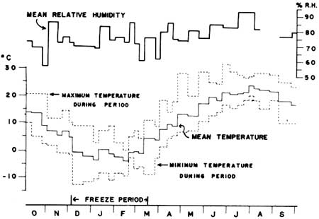
On Fire Island, during the study, the mean annual temperature was 10.3°C with maximum and minimum temperatures of 32°C and -l3°C, respectively (Fig. 8). The freeze-free period was 240 days; however, the maximum daily temperature was below 0°C on only 26 days during the period of observation.
|
| Fig. 8. Mean relative humidity and temperature. |
During the winter months, the winds along the Atlantic coast are predominantly from the north, while during the summer months they are predominantly from the south and west (USDC 1967; Oosting 1954). For barrier islands with a north-south orientation, the onshore winds are largely during the fall and winter, while islands with an east-west orientation, such as Fire Island, have onshore winds predominating during the spring and summer (Figs. 9, 10). Wind speed also shows seasonal trends, being highest in the winter and decreasing through the spring and summer months.

|
| Fig. 9. Offshore wind distribution blowing from between 258° and 59° (from Art 1972). |
It is the high intensity onshore winds that are of extreme importance in the production of salt-spray aerosols which affect spatial and temporal processes of barrier island ecosystems (Oosting 1954; Boyce 1954; Martin 1959). Salt-spray aerosols are formed by the evaporation of droplets ejected from the sea surface by the bursting of air bubbles (Boyce 1951a; Kientzler et al. 1954). The formation of salt-spray aerosols is a function of wind speed; at speeds above 7 m/sec white caps form and the production of aerosols is greatly enhanced (Boyce 1954). The amounts of aerosols impacted on vegetative surfaces in the Sunken Forest are highly correlated with the speed of onshore winds (Fig. 10) (Art et al. 1974).

|
| Fig. 10. Onshore wind distribution blowing from between 79° and 238° and amounts of sodium impacted on vegetation (from Art 1972). |
Variations in the wind speed across the barrier island are produced in response to topographic irregularities. Wind speed, which increases with height above ground, is greatest at the windward crests of the dunes and lowest in the wind shadows just leeward of the crests (Free 1911; Olson 1958a; Willis et al. 1959). Superimposed on the wind speed gradient is the salt-spray aerosol concentration gradient which increases with increasing wind speed, proximity to the ocean, and topographic exposure (Boyce 1954; Martin 1959; Oosting and Billings 1942).
The annual precipitation on the Atlantic barrier-island chain increases from about 100 cm in the north to 140 cm in the south (USDA 1941). Due to the greater atmospheric stability over the ocean, the annual precipitation in coastal areas may be less than in adjacent inland locations (Miller and Frederick 1969).
During the study period, total precipitation was 116.3 cm, distributed relatively evenly throughout the seasons, but varying greatly between individual observation periods (Fig. 6, Appendix IV).
Although the amount of precipitation may be slightly lower in coastal areas, the relative humidity is generally higher and the evaporation lower than in inland areas (Purer 1934; USDA 1941). Fog, mist, and heavy dew are a common occurrence on Fire Island and undoubtedly act as inputs to the water table.
The mean annual relative humidity on Fire Island was 76% during the period of observation (Fig. 8). The minimum and maximum mean relative humidities for observation periods were 56% and 93%, respectively. However, night-time humidities usually reach 99% during the summer months.
The frequency and intensity of storms play an extremely important role in the processes of coastal ecosystems (Oosting 1954; Martin 1959). On Fire Island, the frequency of major storms occur once every 8.4 years (U.S. Army Corps of Engineers 1960). After an unusually severe storm in September 1938, it took several days for sea water that had washed over the primary dune ridge to drain from the swale in the Sunken Forest area (W. Oakley pers. comm.). During the period of this study (October 1968 to October 1969) large storms occurred on 12 November 1968 and 9 February 1969. Neither of these storms caused beach erosion in the Sunken Forest area, although severe erosion was caused in other locations on Fire Island.
| <<< Previous | <<< Contents >>> | Next >>> |
chap1.htm
Last Updated: 21-Oct-2005