|
YOSEMITE
Vegetational Changes in Yosemite Valley NPS Occasional Paper No. 5 |

|
LANDFORMS, SOILS, AND VEGETATION
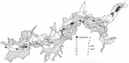
All of the soils of Yosemite Valley originated from materials of similar chemical makeup, mineralogical composition, and under similar climatic conditions. None of the soils in Yosemite Valley approach maturity. Topography, stoniness, and age have been the major influences on soil differentiation. Topography was the most important because it controls surface runoff and ground water, accounts for the distribution of stony soils, and causes the separation of alluvial soils of different ages. Topography caused slight climatic differences between the valley floor, the hotter and dryer south-facing slopes, and the cooler north-facing slopes. The resulting landforms, which are shown in schematic profile across the valley (Fig. 1) and mapped (Fig. 2), are used in this paper as the basic units for analysis of soils and vegetation.
|
| Fig. 2. Landforms in Yosemite Valley. The valley is approximately 11 km x 0.8 km (6.6 x 0.5 miles). Landform As adjoins the Merced River which flows from right to left. (click on image for a PDF version) |
The soils were classified in 1962 according to seven landforms. The lowest are near permanent streams and were recently deposited sands with (A) and without (As) profile development. The B soils occurred at slightly higher positions and showed profile development. The outreach of coarse soils extended to alluvial fans (F) and apron deposits (C lower). Upper talus slopes (C upper) and moraines (D) were the other two landforms. Division within each landform into soil series was based on rockiness, color, and internal drainage.
Recent Alluvium Without Profile Development (As)
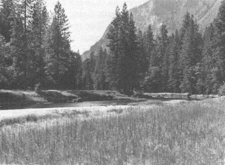
Landform As (Fig. 2) flooded annually and the soil material consisted of sands and larger components deposited by the Merced River, Tenaya Creek, and small tributary streams. No soil profile had developed. Channels caused by flooding and the presence of oxbows gave the landform an uneven surface. Point-bars in the bends of the Merced River illustrated this most recent alluvium.
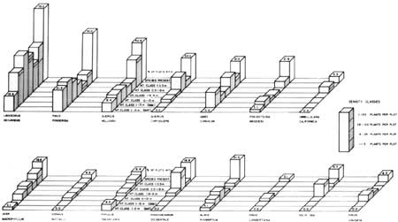
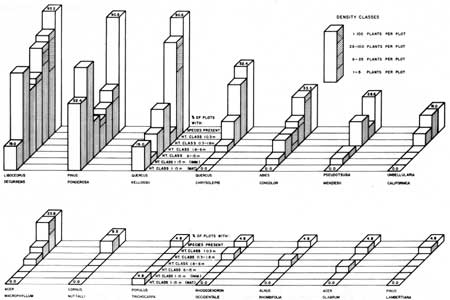
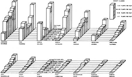
Vegetation rapidly becomes established on the youngest alluvial areas (Fig. 3). Tree species common on other landforms dominated, including Libocedrus decurrens (incense cedar), Pinus ponderosa (ponderosa pine), Quercus kelloggii (black oak), Quercus chrysolepis (canyon liveoak), Abies concolor (white fir), and Pseudotsuga menziesii (Douglas fir). Riparian species such as Populus trichocarpa (black cottonweed), and Alnus rhombifolia (white alder) were abundant locally. The relatively low frequencies and densities of most of the woody species (Fig. 4) suggested open forest. The presence of mature trees of L. decurrens, P. ponderosa, Q. kelloggii, P. menziesii, Acer macrophyllum (big-leaf maple), P. trichocarpa, and A. rhombifolia, as well as trees in nearly all of the shorter height classes, implied continuous invasion of plants on new alluvium. The vigor of the trees indicated healthy individuals and fast growth.
|
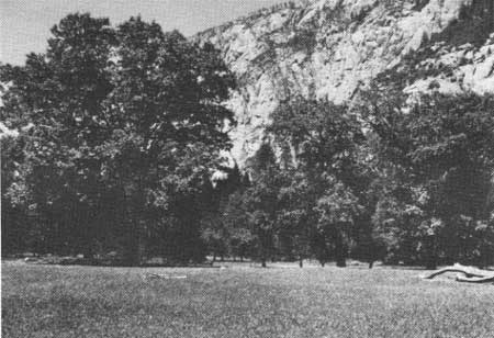
| Fig. 3. Grasses and broadleaved plants quickly invade the sandy point-bars of recent alluvial deposits along the Merced River. |
|
| Fig. 4. Frequency, height classes, and density classes of woody plants on landform As, recent alluvium without profile development. Overall frequency is shown in the back bar for each species by the height and as a percentage. The front bars show frequency by height classes. Hatching indicates density within height classes. (click on image for a PDF version) |
Foliage cover in this open forest type was about 41% by trees and 41% by herbaceous species (Table 1), which was the least tree cover and the greatest herbaceous cover of all the forested types. Herbaceous species with the highest frequencies were Elymus glaucus (blue wild-rye), Carex spp. (sedge), Pteridium aquilinum (bracken fern), Poa pratensis (Kentucky bluegrass), Agrostis alba (redtop), Artemisia douglasiana (Douglas mugwort), Rumex acetosella (sheep sorrel), Equisetum arvense (horsetail), Galium bolanderi (bedstraw), Bromus tectorum (cheat grass), Holcus lanatus (velvet grass), Mentha arvensis (mint), and Potentilla glandulosa (cinquefoil) (Table 2). Meadow vegetation on this landform occurred in the Slaughter House, Leidig, Sentinel, and Cook's meadows.
Table 1 . Cover estimates based on plots 15 m in diameter within the forest vegetation of Yosemite Valley.
| Landform | No.of plots |
Woody vegetation |
Herbaceous vegetation |
Litter | |||
| % Cover | SE | % Cover | SE | % Cover | SE | ||
| Alluvium without soil profile (As) | 33 | 41.0 | 5.33 | 40.8 | 5.71 | 72.4 | 4.42 |
| Alluvium with soil profile (A) | 29 | 56.9 | 4.59 | 37.8 | 6.81 | 91.6 | 2.18 |
| Alluvium seldom flooded (B) | 21 | 54.8 | 5.30 | 22.2 | 6.43 | 93.3 | 2.27 |
| Moraine (D) | 10 | 59.0 | 1.75 | 2.2 | 0.63 | 92.5 | 3.35 |
| Fans (F) | 57 | 46.0 | 3.40 | 10.1 | 2.35 | 75.7 | 4.12 |
| Lower colluvium (C) | 63 | 67.9 | 2.01 | 1.9 | 0.55 | 89.0 | 2.50 |
| Upper colluvium C | 67 | 59.0 | 2.61 | 3.8 | 3.80 | 72.8 | 3.65 |
| Combined | 280 | 55.7 | 1.52 | 13.7 | 1.50 | 81.2 | 1.54 |
SE = Standard error. | |||||||
Table 2. Percentage frequency of herbaceous species in the understory of forest types according to landform.
| Species | Alluvium without profile |
Alluvium with profile |
Alluvium seldom flooded |
Moraine | Fan | Lower colluvium |
Upper colluvium |
| Broadleaved | |||||||
| Achillea lanulosa | 15.2 | 6.9 | 4.8 | 7.0 | 1.5 | ||
| Agastache urticifolia | 9.1 | 10.3 | 4.8 | l.5 | |||
| Apocynum cannabinum | 6.1 | 3.5 | 4.8 | 3.5 | 3.2 | 2.9 | |
| Aquilegia formosa | 13.8 | 1.8 | |||||
| Artemisia douglasiana | 30.3 | 6.9 | 9.5 | 8.8 | 3.2 | 2.9 | |
| Artemisia dracunculus | 15.2 | 6.9 | 5.3 | ||||
| Artemisia tridentata | 1.8 | 2.9 | |||||
| Asarum hartwegii | 6.1 | 10.3 | 9.5 | 17.5 | 15.8 | 13.4 | |
| Asclepias cordfolia | 5.3 | ||||||
| Asclepias speciosa | 3.0 | ||||||
| Aster adscendens | 3.5 | l.5 | |||||
| Boykinia major | 4.8 | 6.0 | |||||
| Brickellia californica | 4.8 | 11.9 | |||||
| Brodiaea lutea | 3.5 | 4.8 | |||||
| Calyptridium umbellatum | 3.5 | ||||||
| Castilleja breweri | 3.5 | 1.5 | |||||
| Chamaebatia foliosa | 10.0 | 7.0 | 1.6 | l.5 | |||
| Cirsium vulgare | 3.0 | 13.8 | 3.5 | 1.5 | |||
| Conyza canadensis | 6.9 | 4.8 | |||||
| Erigeron breweri | 5.3 | ||||||
| Eriogonum latifolium | 6.1 | 4.8 | 10.0 | 7.0 | 3.2 | 1.5 | |
| Fragaria californica | 3.0 | 6.9 | 1.6 | ||||
| Galium bolanderi | 24.2 | 44.8 | 19.0 | 21.1 | 4.8 | 1.5 | |
| Gayophytum diffusum | 6.1 | 3.5 | 9.5 | 10.0 | 5.3 | ||
| Gilia capitata | 3.5 | 4.8 | 10.0 | 5.3 | 3.2 | ||
| Heracleum lanatum | 3.0 | 3.5 | 1.8 | ||||
| Hypericum formosum | 6.9 | ||||||
| Hypochoeris glabra | 1.8 | ||||||
| Hypochoeris radicata | 3.5 | 4.8 | 3.5 | ||||
| Lessingia leptoclada | 9.1 | 4.8 | 8.8 | ||||
| Linanthus montanus | 10.0 | ||||||
| Lotus oblongifolius | 3.0 | 3.5 | 4.8 | 20.0 | 5.3 | 2.9 | |
| Lupinus albifrons | 3.5 | 1.8 | 4.8 | l.5 | |||
| Lupinus arbustus | 3.5 | 7.0 | 4.5 | ||||
| Mentha arvensis | 18.2 | 13.8 | 4.8 | 5.3 | |||
| Micropus californicus | 1.8 | ||||||
| Montia perfoliata | 6.1 | 24.2 | 4.8 | 15.8 | |||
| Navarretia divaricata | 3.5 | 1.6 | l.5 | ||||
| Orobanche fasciculata | 1.8 | ||||||
| Penstemon newberryi | 9.5 | 19.4 | |||||
| Phacelia heterophylla | 6.1 | 4.8 | 7.5 | ||||
| Potentilla glandulosa | 18.2 | 34.5 | 28.6 | 10.0 | 29.8 | 3.2 | 7.5 |
| Rudbeckia hirta | 4.8 | ||||||
| Rumex acetosella | 30.3 | 13.8 | 14.3 | 1.8 | |||
| Rumex crispus | 9.1 | ||||||
| Senecio vulgaris | 4.8 | 1.6 | |||||
| Solidago canadensis | 9.1 | 3.5 | 4.8 | ||||
| Trillium chloropetalum | 4.8 | ||||||
| Vitis californica | 1.6 | ||||||
| Grass | |||||||
| Agrostis alba | 30.3 | 24.2 | 14.3 | ||||
| Aira caryophyllea | 3.0 | ||||||
| Avena barbata | 1.8 | ||||||
| Bromus marginatus | 6.1 | 10.3 | 14.3 | 7.0 | 3.2 | l.5 | |
| Bromus mollis | 6.1 | l.5 | |||||
| Bromus rigidus | 6.1 | 1.8 | |||||
| Bromus rubens | 5.3 | ||||||
| Bromus tectorum | 21.2 | 14.3 | 20.0 | 17.5 | 4.8 | 8.9 | |
| Calamagrostis canadensis | 15.2 | 3.5 | |||||
| Cynosurus echinatus | 1.5 | ||||||
| Deschampsia elongata | 3.0 | 4.8 | |||||
| Elymus glaucus | 57.6 | 75.9 | 52.5 | 31.6 | 15.8 | 11.9 | |
| Festuca megalura | 9.1 | 3.5 | 4.8 | 12.3 | 6.4 | 6.0 | |
| Festuca occidentalis | 6.1 | 6.9 | 4.8 | 10.5 | 3.2 | 4.5 | |
| Festuca reflexa | 1.6 | l.5 | |||||
| Holcus lanatus | 18.2 | 38.0 | 9.5 | 3.5 | l.5 | ||
| Melica imperfecta | 11.1 | 13.4 | |||||
| Muhlenbergia filiformis | 3.0 | 4.8 | |||||
| Panicum pacificum | 6.1 | 6.9 | 4.8 | 1.8 | |||
| Phleum pratense | 3.5 | ||||||
| Poa prarensis | 33.3 | 24.2 | 19.1 | 1.8 | |||
| Poa scabrella | 6.1 | 28.6 | 20.0 | 40.4 | 34.9 | 20.9 | |
| Sitanion hystrix | 4.8 | 20.0 | 19.3 | 3.2 | 4.5 | ||
| Stipa columbiana | 3.0 | 3.5 | 9.5 | 20.0 | 15.8 | 4.8 | 2.9 |
Other | |||||||
| Carex spp. | 42.4 | 58.4 | 14.3 | 30.0 | 10.5 | l.5 | |
| Juncus balticus | 12.1 | 10.3 | 22.8 | 22.2 | 14.9 | ||
| Scirpus spp. | 6.1 | 3.5 | |||||
| Equisetum arvense | 27.3 | 24.2 | 4.8 | 1.6 | |||
| Athyrium filix-femina | 1.8 | 1.6 | 2.9 | ||||
| Dryopteris arguta | 6.9 | 1.8 | 6.4 | 17.9 | |||
| Polystichum munitum | 3.5 | l.5 | |||||
| Pteridium aquilinum | 39.4 | 51.7 | 66.7 | 60.0 | 40.4 | 11.1 | l.5 |
Recent Alluvium with Profile Development (A)
Older alluvial deposits, but those still flooded annually, showed a color profile and were designated landform A (Figs. 1 and 2). These soils had recent surface deposits of fresh sand and silt. Judgment was used to designate some A soils because flooding gradually decreases as the distance from the Merced River increases. No distinct modern flood plain terraces occurred in the valley.
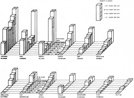
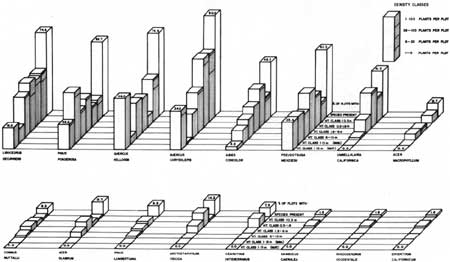
Scattered mature trees of Libocedrus decurrens, Pinus ponderosa, Quercus kelloggii, Populus trichocarpa, and Alnus rhombifolia dominated the forest on landform A (Fig. 5). L. decurrens, P. ponderosa, and Q. kelloggii were the only species in which all size classes occurred. Not only did L. decurrens have the highest frequency of any species (87.9%), but it also had the highest frequency in almost all size classes.
|
| Fig. 5. Frequency, height classes, and density classes of woody plants on landform A, recent alluvium with profile development. Overall frequency is shown in the back bar for each species by the height and as a percentage. The front bars show frequency by height classes. Hatching indicates density within height classes. (click on image for PDF version) |
Pinus ponderosa showed a relatively higher frequency of trees greater than 15 m (50 ft) tall than those less than 15 m tall. Many individuals in the 1.8- to 6-m (6-20 ft) size class were suppressed, dead, or dying. Trees in the two smaller size classes were not vigorous, especially if they were growing in heavy shade. Dense canopy restricts this species.
Quercus kelloggii had the same total frequency (82.8%) as Pinus ponderosa. The high frequency for Quercus resulted primarily from the scattered plants in the seedling and mature classes. Q. kelloggii had a very low frequency in the intermediate size classes. It formed open stands in or near the meadows (Fig. 6).
|
| Fig. 6. An open stand of mature Quercus kelloggii with few weeds or shrubs taller than the grasses. Deer continually browse off the lower branches of the Quercus and search for fallen acorns. |
On this landform, Quercus chrysolepis and Umbellularia californica (California bay) appeared as branched shrubs rather than as young, single-stemmed trees, which was the case on the xeric sites in the valley. Q. chrysolepis appeared in a growth form greater than 2 m (6.6 feet) tall on only one plot; U. californica had not attained 2 m on this landform.
Abies concolor and Pseudotsuga menziesii were present on this landform, but mostly in the lower size classes. P. menziesii occurred on only one plot and A. concolor on three plots with a height greater than 15 m.
The A landform soils had a cover of 57% trees and 38% herbaceous plants (Table 1). The herbaceous species with the highest frequencies in this area were Elymus glaucus, Carex spp., Pteridium aquilinum, Galium bolanderi, Holcus lanatus, Potentilla glandulosa, Agrostis alba, Equisetum arvense, Poa pratensis, and Montia perfoliata (miner's lettuce). Landform A supported only grasslands in several of the valley's meadows.
Older Alluvium with Profile Development (B)
Landform B (Figs. 1 and 2), which was composed of the oldest alluvium, flooded only occasionally. Color and organic profiles separated these soils from those on the recent alluvium. Lake fill materials occurred at shallow depths below the older alluvium, outcropped in small scattered locations, and were exposed in the banks of numerous tributary streams. No textural B horizon existed in this soil. Landform B occurred extensively in the valley.
The alluvial soils showed a varied drainage pattern from excessively well-drained sands at point bar locations and along stream banks to closed depressions that remained wet continuously. However, most of the alluvial soils were well drained and occurred on flat, little-channeled flood plains. Imperfectly and poorly drained soils were very dark grayish-brown and occupied abandoned river channels; a few of which had nearly pure organic matter in the bottoms of the depressions.
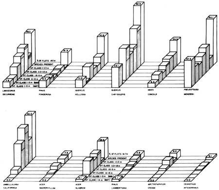
Landform B supported Libocedrus decurrens (95.2% frequency), Pinus ponderosa, and Quercus kelloggii, which occurred in all size classes (Figs. 7, 8). The only mature trees on this landform were individuals of Libocedrus decurrens, P. ponderosa, Q. kelloggii, and Populus trichocarpa. Landform B showed greater dominance of the upland tree species, fewer of the riverine species, and more seedlings of Pinus lambertiana and Acer glabrum (mountain maple) than landform A.
|
| Fig. 7. Frequency, height classes, and density classes of woody plants on landform B, older alluvium with profile development. Overall frequency is shown in the back bar for each species by the height and as a percentage. The front bars show frequency by height classes. Hatching indicates density within height classes. (click on image for PDF version) |
|
| Fig. 8. Dense forest developing on alluvium forms a mixture of tree species of many ages. Closed forest canopies restrict views of the cliffs and waterfalls. |
The B landform had a mean tree canopy cover of 55% and herbaceous cover of 22%, which was a much thinner herbaceous stand than on landform A (Table 1). This suggests that forests on landform B were replacing meadows. The herbaceous species with the highest frequencies were Pteridium aquilinum, Elymus glaucus, Poa scabrella, Potentilla glandulosa, and Galium bolanderi. In comparison with landform A, xeric species had increased; for example, Pteridium had replaced Elymus as the most frequent, P. scabrella was more frequent than Poa pratensis, and Carex spp. were of low frequency. All of the meadows in the valley had areas in the B landform.
Moraines (D)
Terminal moraines occurred near the mouth of Yosemite Valley and lateral moraines were present between Tenaya Creek and the Merced River (Fig. 2). These moraines are late Wisconsin in age and were formed during the third period of glaciation in Yosemite Valley (Matthes 1930). Soils on the moraines have a high stone content. This landform occupies the smallest area of any in the valley.
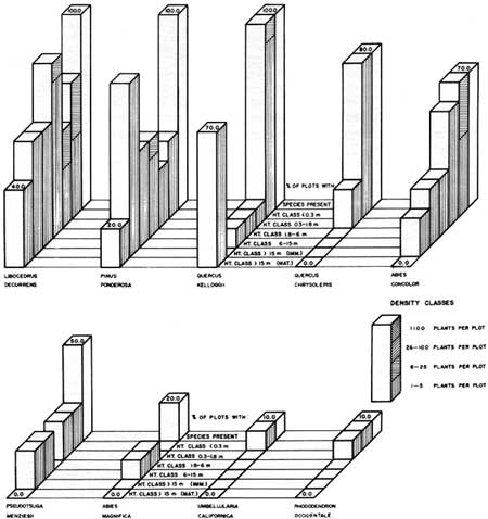
Libocedrus decurrens, Pinus ponderosa, and Quercus kelloggii dominated the vegetation, but Quercus chrysolepis and Abies concolor had relatively high frequencies in the lower height classes (Fig. 9). L. decurrens and P. ponderosa were present in all size classes on this landform, and with Q. kelloggii were the only species with mature trees. Just as on all landforms below the colluvium, Q. chrysolepis and Umbellularia californica occurred as shrubs less than 2 m tall. Abies magnifica (red fir), usually located at higher elevations, existed on two plots on this landform and nowhere else in the valley.
|
| Fig. 9. Frequency, height classes, and density classes of woody plants on landform D, moraines. Overall frequency is shown in the back bar for each species by the height and as a percentage. The front bars show frequency by height classes. Hatching indicates density within height classes. (click on image for a PDF version) |
The mean tree cover was 59% and the mean herbaceous cover 2.2% (Table 1). The only herbaceous species with high frequencies were Carex spp. and Pteridium aquilinum (Table 2). Landform D is the only one in the valley on which Elymus glaucus did not appear in abundance. Few species characterized this morainal vegetation.
Alluvial Fans (F)
Alluvial fan and apron deposits occurred along tributary streams, covering the lowest recent colluvium and extending into the valley upon lake fill (Figs. 1 and 2). They were recognized by their topographic form and position. Soil materials were similar in color but rock fragments were generally smaller than those in the colluvial deposits. Fan materials had been transported by water for too short a distance to wear the rocks round. Stratification of particle size classes seldom occurred. Fans constituted the second largest landform in the valley.
As on most of the other landforms, Libocedrus decurrens, Pinus ponderosa, and Quercus kelloggii dominated the vegetation (Fig. 10). Quercus chrysolepis and Abies concolor also had relatively high frequencies. These species plus Pseudotsuga menziesii and Acer macrophyllum were present on this landform in all size classes, including mature trees. L. decurrens and A. concolor were the major understory trees, as indicated by high frequencies in the intermediate size classes. Many seedlings of Q. kelloggii fail to establish or to reach heights greater than 30 cm.
|
| Fig. 10. Frequency, height classes, and density classes of woody plants on landform F, alluvial fans. Overall frequency is shown in the back bar for each species by height and as a percentage. The front bars show frequency by height classes. Hatching indicates density within height classes. (click on image for a PDF version) |
Mean canopy cover was 46% for trees and 10% for herbaceous plants (Table 1). The diverse un derstory vegetation contained 52 of the 81 recorded species in the forest sampling. Those with the highest frequencies were Poa scabrella (pine bluegrass), Pteridium aquilinum, Elymus glaucus, Potentilla glandulosa, Juncus balticus (Baltic rush), Galium bolanderi, Sitanion hystrix (squirreltail), Bromus tectorum, and Asarum hartwegii (wild-ginger) (Table 2). Bridalveil Meadow was the only meadow on an alluvial fan.
Colluvial Landforms (C)
Colluvial deposits, also called talus, fringed almost the entire valley (Fig. 2). Stones and boulders with diameters greater than 25 cm (10 inches) covered angular-shaped cobble and gravel-sized rock fragments. Material greater than 4 cm (1.5 inches) in diameter exceeded the finer particles in volume. Small remnants of glacial till of Wisconsin age which were scattered over the colluvial slopes did not appear to have extensive influence on these soils. This landform was the most extensive in the valley.
As the alluvial soils, the profile development was correlated with color change. The common sequence of color development of the soils on the colluvial slopes seemed to be the light gray of fresh minerals in the upper colluvium below the rocky cliffs, yellowish brown in the middle of long steep slopes on old colluvium, and grayish-colored soil on gentle foot slopes. This sequence showed where recent torrents had dissected talus slopes.
Colluvial landforms were divided into a lower (<30% slope) and an upper landform (>30% slope) due to differences in vegetation (Figs. 11 and 12). Lower colluvial vegetation was dominated by Quercus kelloggii, Quercus chrysolepis, Libocedrus decurrens, and Pinus ponderosa. The upper colluvium supported abundant Q. chrysolepis and a small number of the other three species (Fig. 13). These species plus Abies concolor and Pseudotsuga menziesii were present in all size classes. Landform C supported higher frequencies of Umbellularia californica and P. menziesii, as well as the Q. chrysolepis, than did the valley floor.
|
| Fig. 11. Frequency, height classes, and density classes of woody plants on landform C, lower talus slopes. Overall frequency is shown in the back bar for each species by the height and as a percentage. The front bars show frequency by height classes. Hatching indicates density within height classes. (click on image for a PDF version) |
|
| Fig. 12. Frequency, height classes, and density classes of woody plants on landform C, upper talus slopes. Overall frequency is shown in the back bar for each species by the height and as a percentage. The front bars show frequency by height classes. Hatching indicates density within height classes. |
|
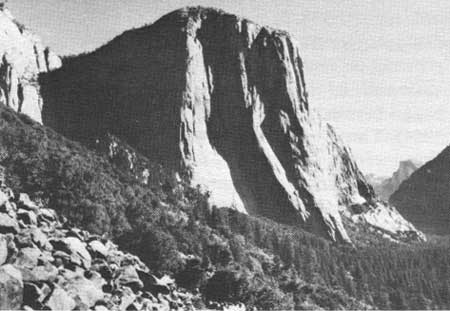
| Fig. 13. Quercus chrysolepis dominates the vegetation on upper talus slopes. The cliff in the background is El Capitan. |
The mean herbaceous cover on the two colluvial landforms was the lowest at 1.9% and 3.8%, and tree canopy was thicker than on other landforms (Table 1). Herbaceous species with the highest fre quencies were Poa scabrella, Juncus balticus, Elymus glaucus, Asarum hartwegii, Penstemon newberryi (beardtongue), Dryopteris arguta (wood fern), and Melica imperfecta (onion-grass) (Table 2).
| <<< Previous | <<< Contents >>> | Next >>> |
sec4.htm
Last Updated: 20-Nov-2007