|
NATIONAL PARK SERVICE
An Identification of Prairie in National Park Units in the Great Plains NPS Occasional Paper No. 7 |

|
INTRODUCTION
The purpose of this report is to provide a basic literature reference on prairie within National Park Service units in the Great Plains. It contains three sections. The first section describes the various prairie vegetation types as classified by Kuchler (1964). The second section includes information on prairies in each of 32 parks in the Great Plains (Figure 1). The third section provides a bibliographic list of prairie studies that will be of use to National Park Service managers, planners and scientists.
|
|
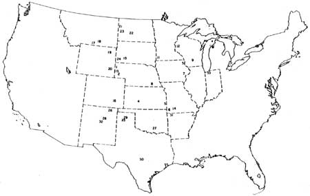
Figure 1. Prairie parks in the Great Plains. Legend for Figure 1 Midwest Region: 1— Agate Fossil Beds National Monument (AGFO) 2— Chimney Rock National Historic Site (CHRO) 3— Effigy Mounds National Monument (EFMO) 4— Fort Larned National Historic Site (FOLS) 5— Fort Scott National Historic Site (FOSC) 6— George Washington Carver National Monument (GWCA) 7— Herbert Hoover National Historic Site (HEHO) 8— Homestead National Monument of America (HOME) 9— Ice Age National Scientific Reserve (ICAG) 10— Indiana Dunes National Lakeshore (INDU) 11— Pipestone National Monument (PIPE) 12— Saint Croix National Scenic Riverway (SACN) 13— Scotts Bluff National Monument (SCBL) 14— Wilson's Creek National Battlefield (WICR) Rocky Mountain Region: 15— Badlands National Park (BADL) 16— Bent's Old Fort National Historic Site (BEOL) 17— Bighorn Canyon National Recreation Area (BICA) 18— Custer Battlefield National Monument (CUST) 19— Devils Tower National Monument (DETO) 20— Fort Laramie National Historic Site (FOLA) 21— Fort Union Trading Post National Historic Site (FOUS) 22— Knife River Indian Villages National Historic Site (KNRI) 23— Theodore Roosevelt National Park (THRO) 24— Wind Cave National Park (WICA) Southwest Region: 25— Alibates Flint Quarries National Monument (ALFL) 26— Capulin Mountain National Monument (CAMO) 27— Chickasaw National Recreation Area (CHIC) 28— Fort Union National Monument (FOUN) 29— Lake Meredith Recreation Area (LAMR) 30— Lyndon B. Johnson National Historical Park (LYJO) 31— Pea Ridge National Military Park (PERI) 32— Pecos National Monument (PECO) (click on image for a PDF version) |
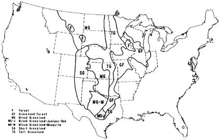
For the purpose of this study, the Great Plains is broadly defined as the areas of grassland extending from the Canadian to the Mexican borders and from the foothills of the Rocky Mountains to western Indiana. The eastern portions of this area are sometimes referred to as the Prairie Peninsula while southwestern areas may be referred to as the Llano Estacado. The area includes several types of grasslands (Figure 2).
|
| Figure 2. Prairie and grassland types in the central United States. (click on image for a PDF version) |
Prairie is a complex vegetation type that has been defined and described in many ways. For the purposes of this report, it is broadly defined as a natural plant community that is dominated by grasses. Potential prairie will include areas undergoing succession towards prairie and areas that could develop towards prairie with proper management.
These definitions are purposely broad. The importance of plants other than grasses must be recognized. Topography cannot be totally ignored. Prairies do not have to be natural to fit these definitions. They could be areas seeded to native species which are developing towards a prairie climax.
Prairies evolved under and continue to be influenced by many environmental factors. Climatic factors such as temperature, humidity, etc. influence vegetation. The most important climatic factor is precipitation. Water is the most limiting factor on prairies, and precipitation, therefore, directly controls the type of vegetation a site will support. The eastern prairie areas obtain enough precipitation to support forests. Fire, the pyric factor, was responsible for maintaining the prairie vegetation because grasses and forbs are adapted to fire while woody vegetation is not. Physiographic factors, such as topography, locally influence vegetation. In addition, some ecologists feel that prairie can only be located on flat to rolling lands. Edaphic factors may control which species occur in an area. Fertility of the soil is directly related to the productive capacity of the area. Some important species are seldom found on coarse textured soils, such as sands. Others may be only found on sands. Soil texture and structure are also related to water infiltration and water-holding capacity. Biotic factors influence the distribution of plants. A broad spectrum of living organisms are found in prairies. The presence or absence of certain organisms may directly influence the rate of succession. The final consideration is the anthropic factor. Man's activities are responsible for deterioration of many prairies. On the other hand, man has restored prairies that were previously destroyed or degraded. Prairies evolved over thousands of years with little influence from man. Now the future of prairies is in the hands of man. Man must understand the other factors and know how to manipulate them if he is to become an effective prairie manager.
Section One
Section One includes descriptions of all of Kuchler's vegetation types represented in the 32 national park units. Descriptions were taken directly from Kuchler (1964). Both common and scientific names of plants are given. Plant nomenclature generally follows Kartesz and Kartesz (1980). Common names generally follow the Nebraska Statewide Arboretum (1982) and Stubbendieck, et al. (1986).
Section Two
The information presented in Section Two was taken from published and unpublished National Park Service reports and from additional material furnished by National Park Service personnel. Following a brief introduction, size of the prairie is given. In most cases, the exact size is known. The prairie size for some parks, especially large parks, is only estimated.
Kuchler's classification map (Kuchler 1964) was used to type each park's potential natural vegetation. The Kuchler vegetation type number and descriptive title is given. The reader should refer back to Kuchler's vegetation types to obtain a description of the presettlement climax vegetation.
The subsection entitled, "Present Vegetation and Prairie Management History" includes a brief description of past management. In most cases, management has not been uniform across the whole unit, and differences between management within a unit are also outlined. Current vegetation and its condition are given when known. The next subsection entitled, "Land Use and Vegetation Within One Mile of the Park Boundary," indicates differences between park resources and those outside of park boundaries.
The following subsection, "Prairie Research," is an annotated bibliography of research conducted in the park. Literature citations are given if the research has been published. Additional sources of information used in preparation of the park report are listed in the General References section.
Maps are included for all of the parks. Prairie areas are designated on the maps, except for the large parks. In these instances, a land classification or similar map is included.
A set of Summary Tables concludes Section Two. These tables include information on acreages, Kuchler's vegetation types, management history, and land use within one mile of the park boundaries.
Section Three
The third section contains a bibliographic list of prairie studies that were conducted outside of National Park Service units. These literature citations are arranged alphabetically and are identified by key words. Most of the cited research was conducted in the Great Plains but applicable work from other areas was included.
| <<< Previous | <<< Contents >>> | Next >>> |
intro.htm
Last Updated: 25-Jul-2008