Last updated: March 3, 2021
Place
2 - Exploring Fort Mason
KIOSK LOCATION: The kiosk is a four-sided metal structure with interpretive panels. It is located east of building 201, at the intersection of Macarthur Avenue and Franklin Street. It is close to Fort Mason's flagpole.
VIEW FROM KIOSK: The kiosk is positioned on a cement sidewalk and is surrounded by lawn. Building 201, the Park Headquarters, is directly east of the kiosk. The Headquarters building is cream colored with a green roof. Fort Mason's chapel is directly ahead and across Pope Road. The chapel has white walls and terracotta clay roof. An accessible parking lot is 50 feet directly south of the kiosk.
KIOSK DESCRIPTION: There are four panels that expand across the entire display and are stacked vertically. The first kiosk panel, titled "Exploring Fort Mason," is a detailed map of Fort Mason and the surrounding area. The second kiosk panel, titled "Featured Hike," provides information about the Great Meadow Loop Trail. The third kiosk panel, titled "What to Do at Fort Mason," describes the various activities one could do at Fort Mason. The fourth kiosk panel delivers cautionary safety messages about your time in Fort Mason today.
KIOSK PANEL #1 TITLE: Exploring Fort Mason
MAP: At the top of the panel is a map of Fort Mason. This map is both informational and for wayfinding. It is oriented with north at the top and represents roughly 64 square miles. You are currently standing in the center of this map and the center of upper Fort Mason. An orange "You Are Here" circle indicates this on the map.
LEGEND: The legend has symbols for amenities, land types, and trails. The trails are highlighted with different patterns or colors to indicate the accessibility and featured trails. The land types have different shadings as well as colors to indicate property lines, dog restrictions and Upper and Lower Fort Mason. Amenity icons are shown on the map indicating parking locations, restrooms, picnic areas, dog restrictions, hostels, fishing locations and the Visitor Center. Also shown are the locations of the nearby bus stops. Please check with S F Muni and Golden Gate Transit by dialing 5 1 1 or go online to w w w dot 5 1 1 dot org for more info.
MAP AMENITIES: Amenities listed by location. Amenities will be listed by location clockwise starting from the "You Are Here" circle.
CURRENT LOCATION: You are currently standing in an area with accessible parking. The 28, 30, 47, and 49 bus stops are southeast of you, past Fort Mason's boundary and along Van Ness Avenue. There is an additional stop for the 30 and 47 three blocks away, at the intersection of Hyde Street and North Point Street.
TO THE WEST: There is additional accessible parking directly to the west of you, around the G G N R A and G G N P C Headquarters Building 201. A third spot for accessible parking is southwest of you and closer to Bay Street. This parking area is accompanied by an accessible restroom. Dogs are allowed on leash in this area of Fort Mason.
On the western boundary of Fort Mason, there is a bus stop for the 43 and additional accessible parking near the Fort Mason Center Entrance. A picnic area borders lower Fort Mason near Landmark Building A, along the water.
TO THE NORTH: Lower Fort Mason has accessible parking. There is also fishing on Pier 2 and Pier 3, north of the accessible parking lot.
TO THE EAST: Heading back east and into upper Fort Mason, there is a hostel in the northernmost portion of upper Fort Mason. A picnic area and accessible parking are directly south of the hostel. Dogs are allowed here on leash. There is an additional picnic area northeast of the hostel, overlooking the bluffs that lead down to the bay. There is fishing along Municipal Pier.
FARTHER EAST: Past Fort Mason's boundary, one can utilize accessible restrooms at the Maritime Museum's Visitor Center along Beach Street. The 19-bus stop is located one block east of this visitor center. The Pacific West Region Informational Center is located one block east and one block north of this bus stop and offers accessible restrooms and accessible parking. Finally, there is an additional accessible restroom in the northeastern most region of the map, near the Hyde Street Pier Historic Ships.
ROADS: All the detailed roadways and trails are wheelchair accessible.
FEATURED TRAIL: The featured hike is the Great Meadow Loop Trail, which extends from the Bay Trail.
OTHER TRAILS: There are various places where the featured trail branches off into other walking routes. For example, at the very northern edge of the Great Meadow, you can continue north to the Bay Trail and wrap around the top of upper Fort Mason. This trail will eventually lead you to the Promenade along the Aquatic Park lagoon. Alternatively, you can travel another 720 feet along the Great Meadow Loop until you reach the section with 3 offshoots and choose any of the other two offshoots. The middle trail will travel around the southwest corner of Upper Fort Mason and eventually loop back around the Great Meadow. The westernmost trail will lead to Fort Mason's boundary at Laguna Street. Continue straight to walk in the direction of the Golden Gate Bridge. Finally, walking 600 feet north along the sidewalk from where you are currently standing will bring you to the hostel. Walking 50 feet northeast will bring you to the chapel. Crossing the street and then walking 550 feet south will bring you to Upper Fort Mason's Main Entrance.
MAP HIGHLIGHTS: Highlights are listed clockwise from where you are currently standing.
TO THE EAST: Along the Promenade, there are the Hyde Street Pier Historic Ships. The Pacific West Region Information Center is next to Historic Cannery Buildings and across the street from the Powell & Hyde Cable Car Turnaround. Ghirardelli Square is two blocks west of these highlights along Beach Street.
UPPER FORT MASON: The Quad and accompanying waysides are southeast of you. The Great Meadow, with the Phillip Burton and Bufano Statue, are southwest. North of where you are standing in upper Fort Mason, there is the Spanish-American War Battery of 1898, Battery Burnham of 1900 to 1909, and Black Point Battery of 1864.
LOWER FORT MASON: In the northwest, there is the Fort Mason Center for Arts and Culture, the Fort Mason Center Office, the SF Art Institute on Pier 2, the Festival Pavilion on Pier 3, and the San Francisco Maritime National Historic Park Headquarters and Library between Pier 2 and Pier 3.
MAP LABELS: This is a list of all place names that appear on the map, divided into quadrants and then listed by category.
NORTHEAST QUADRANT: You Are Here
AMENITIES: Accessible restrooms, Accessible parking, Visitor Center at the Pacific West Region Information Center, Visitor Center at the Maritime Museum, Bus stops 19, 30, and 47
ROADWAYS AND TRAILS: Bay Trail, including The Promenade, Jefferson Street, Beach Street, Polk Street, Larkin Street, Hyde Street
FEATURES: Hyde Street Pier Historic Ships, Aquatic Park and Aquatic Park Historic District, Powell and Hyde Cable Car Turn Around, Ghirardelli Square, Black Point Battery and Battery Burnham, The General's Residence
SOUTHEAST QUADRANT:
AMENITIES: Accessible parking, Bus stops 28, 30, 47, 49,
ROADWAYS AND TRAILS: North Point Street, Bay Street, Van Ness Avenue, MacArthur Avenue, Franklin Street, connecting to Upper Fort Mason Main Entrance
FEATURES: The Quad
SOUTHWEST QUADRANT:
AMENITIES: Accessible Parking at the Headquarters Building, Accessible Restrooms in the Great Meadow, Accessible Parking south of these restrooms, Accessible Parking at the Fort Mason Center Entrance
ROADWAYS AND TRAILS: Bay Trail, including Great Meadow loop, Marina Boulevard, Laguna Street, Buchanan Street, North Point Street, Bay Street
FEATURES: Fort Mason Center Entrance, Representative Phillip Burton Statue, Great Meadow
NORTHWEST QUADRANT:
AMENITIES: Fishing, Accessible parking in lower Fort Mason, Picnic area in lower Fort Mason, Hostel, Picnic Area, Accessible parking near the hostel
ROADWAYS AND TRAILS: Bay Trail, Macdowell Road, Funston Road, Pope Street, Franklin Street
FEATURES: Fort Mason Center for Arts and Culture, S F Art Institute, Festival Pavilion, Fort Mason Center Office, San Francisco Maritime N H P Headquarters and Library, Spanish-American War Battery
TEXT: Dogs must be on leash. Pick up pet litter. There can be no glass, no B B Q grills, and no camping at Fort Mason.
TEXT: What To Do at Fort Mason
FEATURED HIKE: Great Meadow Loop Trail
LIST: Trail data
- 0.5 miles or 0.8 kilometers
- Average 3.5% slope with a maximum 8% slope
- Asphalt terrain
- Average 1% side slope with a maximum 3% side slope
- Average 8 feet trail width with a minimum of 60 inches
TEXT: The Fort Mason Great Meadow is large open area filled with meandering paths surrounded by grassy lawns. The entire loop, including the paths along Laguna and Bay, is a of total 0.5 miles. Along this loop you can take in views of the Golden Gate Bridge and Lower Fort Mason Center. There are several accessible benches along the pathways as well.
DESCRIPTION OF IMAGE: A graphic depiction detailing the elevation of the featured hike. You are currently 80 feet above sea level. After 0.125 miles, you will be near the Bufano Statue and will be a little under 80 feet above sea level. After 0.25 miles, you will be 60 feet above sea level. After 0.375 miles, you will be about 40 feet above sea level. You will pass the Burton Statue as you travel uphill and conclude your walk at 0.5 miles and 80 feet above sea level.
TEXT: History Walk. Download the free N P S Golden Gate app and take a self-guiding tour of Fort Mason. This one-mile tour reflects on the role that this 19th Century U S Army post played in San Francisco's history. You can download the app on the Apple App Store or at Google play.
TEXT: Bicycling. Fort Mason is the doorway to San Francisco. Ride from here across the Great Meadow to the Marina Green and on to Crissy Field promenade, Fort Point and the Golden Gate Bridge.
TEXT: Bicycling Etiquette. Share paths safely. Bicycles may not exceed 15 m p h and must slow to 5 m p h around corners and when passing other path users. Yield right of way to pedestrians, strollers and wheelchairs.
TEXT: Accessibility. Nearly all of the paths at Fort Mason are wheelchair accessible. Enjoy views from the Great Meadow or visit the Black Point Battery picnic area and historic site by following a route to the hostel.
TEXT: Dog Regulations. Federal Law requires dogs to be on leash at all times in Fort Mason as a national park area 36 C F R Part 2.15. Dog walkers must obey all federal regulations and also pick up after their pets.
TEXT: Community Gardens. Visit this restful island in the bustling city. Flowers, veggies, birds and butterflies thrive here, along with neighborhood gardeners. Please respect their peace and privacy. No Picking. Entrance is on Franklin Street.
DESCRIPTION OF IMAGE: A picture of the Fort Mason Community Gardens. Dirt paths wind between plots of vegetables and flowers. Some trees offer shade, and a greenhouse is in the foreground. A large grassy path is beyond the Community Gardens, dotted with eucalyptus trees.
TEXT: Fisherman's Wharf Hostel. Gain a greater understanding of the world and its people through hosteling. Located at the end of Franklin Street, American and international budget travelers can stay in shared or private rooms. Cafe Franco serves 3 meals a day. A logo indicates that the hostel is part of Hosteling International. For information visit: w w w dot SF Hostels dot com.
DESCRIPTION OF IMAGE: A picture of four people. They are inside the Fisherman's Wharf Hostel, looking down at a map and smiling.
CAPTION: Free information about San Francisco is available in the hostel nearby.
TEXT: Where are the historical ships? Visit San Francisco Maritime National Historical Park at Hyde Street Pier.
DIRECTIONS TO HYDE STREET PIER ON FOOT: There are two options. 1 Follow Pope Street north to the hostel and around its west side. 2 Take the path to the Great Meadow and then follow the Bay Trail east 0.9 miles.
DIRECTIONS TO HYDE STREET PIER BY CAR: Left out of main entrance onto Bay Street. Left onto Van Ness. Right onto North Point. Left at Polk.
DESCRIPTION OF IMAGE: image of people sitting on the grassy lawn near the Maritime Museum. Historic ships are docked at Hyde Street Pier in the distance.
CAPTION: Historic ships at San Francisco Maritime National Historical Park.
TEXT: Fort Mason Center for Arts and Culture. Today, lower Fort Mason has been converted into a nonprofit cultural center. A park partner of the Golden Gate National Recreational Area, Fort Mason Center for Arts and Culture houses dozens of art organizations and presents adventurous and engaging art exhibitions.
LIST:
- Caution. Bring layered clothing. Weather can turn windy, foggy and cold very fast. Fort Mason is an urban park. Be aware of your surroundings. Exercise common sense, especially after dark. Do not leave valuables in your car.
- For emergencies dial 9 1 1.
- For more information got to w w w dot n p s dot g o v forward slash g o g a
- Finally, you can help preserve the parks by becoming a volunteer or joining the Golden Gate National Parks Conservancy, the parks' nonprofit support partner. For more information call 415 4 R PARKS or visit w w w dot parks conservancy dot org.
KIOSK PANEL #2 TITLE: A Vanished Landscape
TEXT: What can we gain from stories of the past? Several nations have claimed this site. For thousands of years the Ramaytush Ohlone lived in permanent and seasonal villages along the San Francisco Peninsula. Cooking hearths and other cultural remains were discovered not far from where you stand.
In 1776 Spanish soldiers, settlers, and missionaries claimed the San Francisco Peninsula for Spain. By 1801 all of the Ramaytush Ohlone had been incorporated into Mission San Francisco de AsÃ,s, and about eighty percent of their population had died from disease and from poor living and working conditions.
TEXT: The Spanish military used this bluff as a lookout for ships, and in 1797 built a small gun battery, Batteria de San Jose, to protect a ship anchorage on the east side of the point. Eventually, California passed from Spain to Mexico and then to the United States.
In 1850 President Millard Fillmore reserved this area, known as Black Point, for military use. The U S Army ignored the site for many years but hurried to fortify the point in 1863 when the Civil War raised concerns about a Confederate or British invasion of San Francisco's harbor. Renamed Fort Mason in 1882, the post remained an active military installation for over a century.
MAP: of Yelamu Ohlone, Spanish, and early U S Army sites in San Francisco. The map is oriented so that north is at the top.
LEGEND: Designated military areas of 1851 are shaded dark green. Presidentially designated military boundaries of 1850 are marked by a dashed line. Spanish establishments of 1800 are represented as a star. Circles are used to demarcate Ohlone settlements pre 1776.
DESCRIPTION OF MAP FROM NORTH TO SOUTH: The southernmost site was an Ohlone Settlement called Chutchui. It was positioned in central San Francisco. The Spanish establishment "Mission Dolores" was almost adjacent to this site. There was another Ohlone settlement further up and closer to the bay called Sitlintac, on the eastern side of San Francisco. The next site up was a spanish establishment named Yerba Buena, which was positioned near the coast in what is now San Francisco's financial district. Every other site is separated on the map by a dashed line that depicts a presidentially designated military boundary. This boundary ran northeasterly across the top of San Francisco. It also cut around the Presidio and Fort Mason. In the Presidio, there was one Ohlone site called Petlenuc, and two spanish establishments named El Presidio and Castillo de San Joaquin. At what is now Fort Mason, there was a spanish establishment named Batteria San Jose. A "You Are Here" circle indicates that you are currently just below Batteria San Jose.
DESCRIPTION OF IMAGE: A black-and-white photograph of Black Point and the terrace gardens. Simple houses are built along the water, and the General's Residence sits up on a hill with dense vegetation.
CAPTION: Black Point around 1860.
DESCRIPTION OF IMAGE: A photograph showcases the officer's housing engulfed by shrubs and trees. Credit Bancroft Library. Small pathways wind through the garden.
CAPTION: In the 1850s, some of the city's best known citizens, including John C. Frémont, built homes and planted gardens on the point. They were considered illegal squatters on government land, and the army evicted them in 1863. Some of their historic homes remain.
DESCRIPTION OF IMAGE: This photo is titled "Earthquake Refugee Camp," and shows Fort Mason in 1906. Tents are pitched in the grassy field. People travel down the bordering road either on foot or in a horse-drawn carriage.
CAPTION: Devastated San Franciscans fled to Fort Mason after the 1906 earthquake. Having lost their homes to the earthquake or the fires that followed, they lived in military tents and ate army rations.
DESCRIPTION OF IMAGE: Titled "World War Two Command Center." This photograph depicts military personnel at Fort Mason. Women stand in a line at Fort Mason's parade grounds and hold their arms up in salute to the American flag. Some men with instruments stand near them and face the flag.
IMAGE LOCATION: Two in-color images are placed below these photos.
MAP: A map of Marin County and San Francisco City and County. The map is oriented so that north is at the top.
LEGEND: Land that is shaded pale green is land within authorized boundary of the Golden Gate National Parks. Land that is shaded light green is N P S managed Golden Gate National Parks land. Land that is shaded dark green is Golden Gate National Parks land managed by the Presidio Trust.
LAND TYPES: The following are the land types listed from north to south. The eastern strip of Tomales Bay is land that is within the authorized boundary of the Golden Gate National Parks. This includes Martinelli Ranch at the end of Tomales Bay. Olema Valley, on the eastern border of Point Reyes National Seashore, is N P S managed golden Gate National Parks land. This area extends to Stinson Beach. A large segment of land east of Olema Valley is land that is within the authorized boundary of the Golden Gate National Parks, and includes Bolinas Ridge, the Marin Municipal Water District, and Mount Tamalpais State Park. Muir Woods is within this land segment, but it is N P S-managed Golden Gate National Parks land. The southern tip of Marin County is N P S managed Golden Gate National Parks land, and includes Muir Beach, Tennessee Valley, Marin Headlands, Point Bonita, and Fort Baker. Angel Island State Park, within the bay and off of Tiburon, is land within the authorized boundary of the Golden Gate National Parks. Alcatraz Island is NPS-managed Golden Gate National Parks land.
N P S managed Golden Gate National Parks land is immediately across the Golden Gate Bridge in San Francisco. This includes Crissy Field, Fort Point, and Fort Mason. The Presidio is Golden Gate National Parks land that is managed by the Presidio Trust.
Lands End, at the western edge of San Francisco, is land within the authorized boundary of the Golden Gates National Parks. From Lands End, there is a continuous strip of N P S managed Golden Gate National Parks land including Sutro Heights, Cliff House, Ocean Beach, and Fort Funston.
Farther south in San Mateo County, Milagra Ridge, Mori Point, and Sweeney Ridge are all N P S managed Golden Gate National Parks land. From here, the large and expansive San Francisco Watershed covers land within the authorized boundary of the Golden Gate National Parks. At the southern edge of the watershed, Phleger Estate is N P S managed Golden Gate National Parks land.
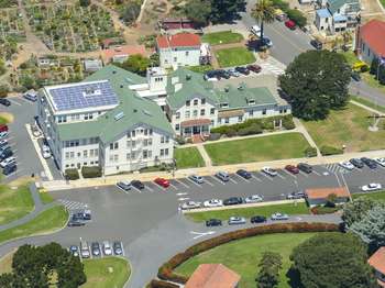
DESCRIPTION OF IMAGE: An aerial view of Fort Mason and accompanying G G N R A sites. Municipal Pier and the rolling hills of Fort Mason are in the foreground. Crissy Field extends along the water from Fort Mason and meets the Presidio and Fort Point at the mouth of the bay. The Marin Headlands and Point Bonita are on the other side of the Golden Gate Bridge.
CAPTION: In 1972, Fort Mason became part of the Golden Gate National Recreation Area -- established to protect natural, cultural, and historic treasures in an urban area.
LIST:
- Caution. Bring layered clothing. Weather can turn windy, foggy and cold very fast. Fort Mason is an urban park. Be aware of your surroundings. Exercise common sense, especially after dark. Do not leave valuables in your car.
- For emergencies dial 911.
- For more information got to w w w dot n p s dot g o v forward slash g o g a
- Finally, you can help preserve the parks by becoming a volunteer or joining the Golden Gate National Parks Conservancy, the parks' nonprofit support partner. For more information call 415 4R PARKS or visit w w w dot parks conservancy dot org.
KIOSK PANEL #3 TITLE: Memorable People of Fort Mason
TEXT: What makes a person memorable? Over the centuries, a number of prominent and influential people have lived in or passed through Fort Mason. These are but a few of the impactful personas whose histories have intersected with this site.
TEXT: John Charles Frémont. 1813 through 1890. John Frémont is a renowned American explorer who mapped the West. He was responsible for the brutal slaughter of countless native peoples on his expeditions, yet was an abolitionist. Captain Frémont is attributed with giving the Golden Gate its name in 1846. He became military governor of California, a U S Senator, and the first Republican U S presidential candidate before serving as a Union general during the Civil War. In the 1850 to 60s, Frémont built and lived in a home overlooking the bay on government land without authority.
DESCRIPTION OF IMAGE: John Frémont wears a suit with a bowtie and a solemn expression. He is balding and bearded. His left hand grasps his suit's lapels.
TEXT: Jessie Benton Frémont. 1824 to 1902. Jessie Frémont lived here with John Frémont after traveling from the East Coast via ship and over the Isthmus of Panama with their young daughter. Jessie was a well known writer and a staunch abolitionist who befriended Reverend Thomas Starr King, a Unitarian minister known for his powerful sermons that advocated for the rights of free Blacks. King wrote fiery abolitionist speeches in Jessie's study, and the two hosted literary and political salons with influential figures of the period, including Bret Harte and Herman Melville.
DESCRIPTION OF IMAGE: essie Benton Frémont wears her dark hair back in a bun. Her expression is serious. Her dress has a deep neck, and white lace extends to her neck.
TEXT: Richard Barnes Mason. 1797 to 1850. Fort Mason is named for Richard Mason, who was appointed military governor of California before statehood from 1847 to 1849. He replaced John C. Frémont as military governor after Frémont refused to step down and recognize presidential appointee General Stephen Kearny as governor. General Mason is credited with sparking the California gold rush after touring the gold discovery site at Sutter's Mill in July 1848 and submitting a widely publicized official report to President James K. Polk.
DESCRIPTION OF IMAGE: Richard Barnes Mason wears an officer's uniform with two rows of brass buttons and a high collar. His hair is short and slightly curly, and he is clean shaven.
TEXT: Arthur Macarthur Junior. 1845 to 1912. General Arthur MacArthur Junior lived in Quarters 1 at Fort Mason from 1903 to 1907. MacArthur's career spanned the Civil War through the Philippine American War. As military governor of the Philippines in 1900 to 1901, MacArthur persuaded captured Filipino leader Aguinaldo to swear allegiance to the US, turning the war around. MacArthur and his son, General Douglas MacArthur, who also briefly lived at Quarters 1, were the first father and son to receive the Congressional Medal of Honor.
DESCRIPTION OF IMAGE: Arthur Macarthur Junior stands facing the left, so that he is in profile. He has short hair, a thick mustache, and wears a monocle. He is in an officer's dress uniform, with thick shoulder pads, a sash, and two rows of brass buttons. He is decorated with various medals.
TEXT: David Colbreth Broderick. 1820 to 1859. U S Senator David Broderick died at Fort Mason in the home of his friend Leonidas Haskell after his political enemy David Terry shot him in a duel. Broderick opposed the expansion of slavery and worked closely with political friends, including Haskell, to support the anti-slavery movement. Terry was Chief Justice of the California Supreme Court and advocated extending slavery into California. When Terry lost a re-election bid because of his pro-slavery views, he challenged Broderick to a duel at Lake Merced and mortally wounded him. Broderick's friends brought him back to Fort Mason before he died.
DESCRIPTION OF IMAGE: David Colbreth Broderick wears a suit and bowtie. He is heavily bearded with short brown hair.
TEXT: Frederick Funston. 1865 to 1917. General Frederick Funston stood only five feet tall, but was a giant of American military history. Medal of Honor winner, outspoken advocate for U S imperialism, and captor of Filipino leader Emilio Aguinaldo, Funston was as colorful and controversial a figure as anyone in the US around 1900. After the great earthquake of April 18, 1906, Funston ordered soldiers to assist in disaster response and relief efforts from Fort Mason for more than a week, until General Adolphus Greely assumed control. Most San Franciscans considered Funston a hero, but others thought he had overstepped his authority.
DESCRIPTION OF IMAGE: Frederick Funston stands facing the right, so that he is in profile. He wears an officer's service cap and uniform. His hair is short, and he is lightly bearded.
TEXT: John L. Dewitt. 1880 to 1962. Lieutenant General John L. DeWitt lived at Fort Mason from 1939 to 1943 and was the U S Army officer in charge of protecting the West Coast from Japanese attack during the early part of World War 2. DeWitt relied more on information from biased politicians than military intelligence or F B I reports. He decided to enforce President Franklin D. Roosevelt's Executive Order 9 0 6 6 by relocating over 120,000 Japanese Americans and Japanese immigrants from the West Coast to hastily constructed concentration camps across the western states and as far east as Arkansas.
DESCRIPTION OF IMAGE: John L. DeWitt wears a heavily decorated officer's uniform and looks to the left. He is bald, and wears eyeglasses.
TEXT: Haskel House. The Leonidas Haskell house was originally built in the 1850s. Seen here as officers' quarters in the 1930s, it is now known as Quarters 3 and still serves as a residence today.
DESCRIPTION OF IMAGE: Photo of the Haskel House. It is a large boxy home with bay windows, two chimneys, and a porch. Trees and shrubs surround the home.
LIST:
- Caution. Bring layered clothing. Weather can turn windy, foggy and cold very fast. Fort Mason is an urban park. Be aware of your surroundings. Exercise common sense, especially after dark. Do not leave valuables in your car.
- For emergencies dial 9 1 1.
- For more information got to w w w dot n p s dot g o v forward slash g o g a
- Finally, you can help preserve the parks by becoming a volunteer or joining the Golden Gate National Parks Conservancy, the parks' nonprofit support partner. For more information call 415 4 R PARKS or visit w w w dot parks conservancy dot org.
KIOSK PANEL #4 TITLE: A Vanished Landscape
TEXT: How do we judge our lasting impacts? SANDY WILDERNESS SURROUNDED EARLY FORT MASON.
TEXT: You are standing in a vastly transformed landscape, on a broad bluff that projects out into the bay. Try to picture the miles of sand dunes that once stretched to the south and west, giant mounds sculpted by northwesterly winds. Imagine the tidal marsh and natural cove that the native Ohlone people knew on the bluff's west side-long since filled in, built over, and bordered by a modern marina.
All of San Francisco has been profoundly altered. The dunes have disappeared beneath buildings, roads, and nonnative plants and trees. The shoreline along the bay-both east and west of here-has been reshaped with fill and construction. Fort Mason's steep rocky shoreline preserves a small remnant still in a natural state. It supports intertidal habitats that look much as they did when the Ohlone harvested shellfish from them centuries ago.
DESCRIPTION OF IMAGE: A historic painting of Fort Mason. In the foreground, coastal dunes are intercepted by a large dirt road. Red buildings, one with a high smokestack, line this road. In the background, Fort Mason is green and heavily vegetated. A few buildings are interspersed within the thick shrubs. The American flag flies high over San Francisco's bay.
CAPTION: "Spanish soldiers and settlers that arrived here in 1776 called this bluff Punta Medanos de Arenas-Sand Dune Point. This painting depicts the American army post as it appeared in 1866 and was renamed Fort Mason in 1882."
TEXT: The Natural side of Fort Mason.
TEXT: A variety of trees and plants grow at Fort Mason today, providing habitat for birds, butterflies, and other creatures. Here are just a few of the species you might see today.
Maybe you've caught sight of Fort Mason's brilliant green parrots and wondered whether your eyes deceived you. They didn't. A flock of wild parrots, descended from escaped pets, moves between Fort Mason and other San Francisco neighborhoods. Most of the birds are red-masked conures, but the flock also includes mitered conures and hybrid offspring.
DESCRIPTION OF IMAGE: A photo of two white-crowned sparrows (Zonotrichia leucophyrs) is in the top left corner, credit Mark Bitner. The male sparrow has a black cap with white streaks, whereas the female sparrow has brown streaks on her head.
DESCRIPTION OF IMAGE: Anna's hummingbird (Calypte anna) is in the top right corner, credit Peter Latourrette. The adult male hummingbird has a brilliant red crown, with a green sheen to the rest of his feathers. He hovers in the air near a red flower. His wings are beating so quickly that they appear blurry.
DESCRIPTION OF IMAGE: A red-headed conure (Aratinga erythrogenys) is below these photos, credit Mark Bitner. The parrot has a bright red crown, a green body, and green tail feathers. It has white eyespots. Its beak looks thick and powerful.
DESCRIPTION OF IMAGE: A Brandt's cormorant (Phalaerocorax penicillatus) is to the right of this photo, credit John Martini. The black bird has a long, slender neck and an oval body. It sits on the edge of a rock and looks down at water.
DESCRIPTION OF IMAGE: A buckeye butterfly (Junonia coenia) is below this photo, credit Robert A. Behrstock. The butterfly rests on the ground with its wings outstretched. The wings are brown, with orange stripes and large eyespots along the edge. The butterfly's body is brown and fuzzy.
TEXT: A rugged landscape. When the US Army claimed this area in 1850, dense scrub, California buckeye and bay laurel trees crowded the shoreline. The dark trees contrasted so sharply with the area's sand dunes, civilian residents called the bluff's eastern edge (below) Black Point. The laurels and all but one buckeye are gone.
DESCRIPTION OF IMAGE: An image of Black Point. The steep topography is covered in dense vegetation. A path along the water's edge cuts into the vegetation. In the background, the hills are not as dense with trees. A few buildings are scattered throughout the coastal prairie.
TEXT: The city filled the cove and marsh west of this bluff to provide a site for the Panama-Pacific International Exposition of 1915. You can get a sense of the vanished landscape by visiting the restored marshland and dunes at Crissy Field, west of the San Francisco Yacht Club.
MAP: A map of Crissy Field and Fort Mason's past and present shoreline. In 1856, the shoreline did not extend as far into the bay. An inlet of water also wove its way into Crissy Field. The present shoreline extends much farther, and includes manmade piers and docks.
LIST:
- Caution. Bring layered clothing. Weather can turn windy, foggy and cold very fast. Fort Mason is an urban park. Be aware of your surroundings. Exercise common sense, especially after dark. Do not leave valuables in your car.
- For emergencies dial 9 1 1.
- For more information got to w w w dot n p s dot g o v forward slash g o g a
- Finally, you can help preserve the parks by becoming a volunteer or joining the Golden Gate National Parks Conservancy, the parks' nonprofit support partner. For more information call 415 4 R PARKS or visit w w w dot parks conservancy dot org.
DIRECTIONS TO NEXT WAYSIDE: Travel 28 feet southeast until you have reached the end of the sidewalk. Cross Franklin Street. Turn right and cross the street again. Walk 480 feet south, and then turn left to continue on the sidewalk. Walk 320 feet. Cross Macarthur Avenue. Turn left and walk north 40 feet to reach the next wayside.