Last updated: October 6, 2022
Place
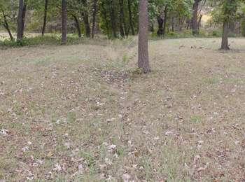
Alcove Spring Swales
Quick Facts
Location:
near Marysville and Blue Rapids, Kansas
Significance:
Visible trail ruts
Designation:
National Register of Historic Places
MANAGED BY:
Amenities
2 listed
Historical/Interpretive Information/Exhibits, Trailhead
A map of Passport and Places to Go locations for National Historic Trails.
Alcove Spring was hit by a tornado in June 2022. The area received significant damage; some trails are impassable and there are many downed trees and unstable rocks. Consider delaying your visit. As always, your safety is your responsibility, please recreate responsibly. Contact the Alcove Spring Preservation Association for more information.
The hilly area around Alcove Springs made travel difficult for emigrants. Heavy wagons being pulled forward by livestock dug into the ground, creating ruts. These ruts were deepened and lengthen by wagons wet from river crossings, which made the ground muddy. The ruts were maintained, and grew, by the thousands of wagons that traveled through this area. When the Oregon Trail stopped being used, grasses and other plants slowly covered over the ruts, turning them into smooth depressions in the ground called swales. These trail swales cans still be seen today. Across the road from the parking lot for Alcove Spring are informative signs that point out the nearby swales.
Site Information
Location (6 miles South of Marysville on the East River Road)