Last updated: December 2, 2022
Place
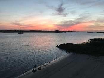
Matanzas Inlet/River
Quick Facts
Amenities
1 listed
Scenic View/Photo Spot
What connects Matanzas Bay to the Matanzas Inlet and flows right past Fort Matanzas? The Matanzas River of course! (You may notice a bit of a theme here.) Unlike most rivers, the Matanzas doesn't flow in just one direction. It is a tidally influenced waterbody that connects two ocean inlets- one at the port city of St. Augustine, and the other fourteen miles south (as the crow flies) at Fort Matanzas National Monument. Depending on if the tide is outgoing or incoming, the river may be full to its banks and flowing inland, or exposing lots of shoreline and streaming towards the sea. Because the inlets are relatively narrow, the currents can clip along at four knots during a spring tide when water is being forced in or out of the constricted openings. This is also when the tidal range is at its greatest at approximately 6 feet difference.
All told the river is nearly 23 miles long, and on its course between the inlets it forms the western boundary of Anastasia Island, a classic east coast barrier island. The Matanzas technically runs for another seven miles or so south of the southern inlet until it melds with the Halifax River at about the Volusia County line. Much of this reach is in fact the result of dredging to complete the Intracoastal Waterway in this area in 1907. While the depth of the river varies greatly depending on the tidal cycle, in the Fort Matanzas area lower spots within the river can reach as deep as twenty feet.
The Matanzas Inlet is the only remaining un-dredged inlet on the east coast of Florida. The inlet's position at the southern tip of the barrier island has progressed even further south over the centuries as the island itself has accreted with the littoral, southward flowing prevailing current. When the Spanish colonists built Fort Matanzas in 1740-42, the position of the inlet was more directly across from where the fort stands today. They constructed the formidable, coquina block watchtower to defend the southern waterway approach to St. Augustine. That city, founded by the Spanish in 1565, is now the nation's oldest port, and Matanzas Bay and the St. Augustine Inlet serve as its maritime entrance. Also in 1565, the Matanzas Inlet was witness to another historical event- the slaughter of about 250 French colonists by the Spanish as the two European powers vied for control of North America. "Matanzas" is in fact the Spanish word for "slaughters".
Though possessing of a violent name, the Matanzas River on most days epitomizes the tranquility of an "old Florida" natural landscape. The river is fed by many tidal creeks that help support vast areas of salt marsh along its flanks. The salt marsh is made up of cordgrass, needle rush, mangroves, and other plants that are tolerant of the rising and falling water levels, and the salinity of a system that is a mixture of ocean and fresh water. Oysters in particular do well in an estuarine environment, forming large beds and bars in some locations, where they help filter out and break down pollutants that are present in the water. In the shallow waters of the marsh many marine organisms find shelter when they are young and growing before heading out to sea as adults. In this way the marshes of the Matanzas River estuarine system act as a "nursery" for multitudes of fish, shellfish, and crustaceans (like shrimp), many of which are consumed by people. The marshes of the river also provide another service which benefits people. They are excellent at soaking up water and wind energy from storms off the ocean (including hurricanes), and so help keep inland areas from flooding and suffering even greater damage. For both natural and historical reasons, the Matanzas River is an integral feature of northeast Florida.