Last updated: July 21, 2023
Place
Blow-Me-Down Bridge
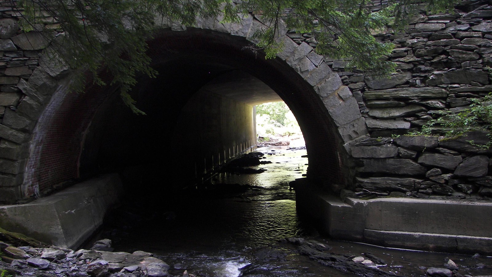
Blow-Me-Down Bridge is adjacent to Blow-Me-Down Mill and the historic entry point to Blow-Me-Down Farm. The elaborate stone bridge provided access to the estate via the formerly named River Road. Built in 1888, it served as crucial infrastructure in the town of Cornish. Though the road has been redirected, parts of its stone structure are still visible today from the Blow-Me-Down Trail.
Blow-Me-Down Farm, the country place of Charles and Hettie Beaman beginning in 1882, is located just west of modern-day NH Route 12A next to the Connecticut River. The Chase family, among others, had previously owned the property, but Charles Beaman made many improvements to the land and structures during his time there.
One such improvement was the construction of a substantial stone bridge over Blow-Me-Down Brook allowing the traffic from the then-named River Road, now known as NH 12A, to pass over the brook and access his estate. A wooden bridge dating to the first half of the nineteenth century stood at the site, but it did not befit the grand estate entrance that Beaman envisioned for his country home. The wooden bridge had been the subject of numerous repairs, and in October 1887 it was closed for several days to fix the middle pier. The Town of Cornish had contracted to rebuild a wooden bridge, but Charles Beaman and his father-in-law, William Evarts, offered funds to build a more substantial stone bridge.[1]
By the spring of 1888, Cornish mason Jabez Hammond was heading up construction of a stone-arch bridge designed by Joseph Morrill Wells of the architectural firm of McKim, Meade & White. Wells’ design featured rustic dry-laid fieldstone masonry walls, a single barrel brick vault, and an oversize stone block at the center of each of the parapet walls. Beaman’s bridge was built on the site of the old wooden bridge and was completed in July of 1888. The new bridge provided a handsome approach to the main entrance of Blow-Me-Down. Its traditional design and construction reflected Beaman’s interest in creating visual harmony between his estate and the surrounding rural countryside.[2]
Beaman’s Blow-Me-Down bridge was modified in 1926-1927 during the improvements to River Road (which had been renamed Wilson Road in 1913) to prepare it for automobile use. At the bridge, the state widened the downstream side of the road, and smoothed the curve of the southern approach. The south side of the bridge was rebuilt with the same stone walls and arch, but the underlying brick vault was extended in concrete.[3] The original stone arch north face of the bridge was left intact, at a good distance from the new road.[4]
Blow-Me-Down bridge was then partially demolished when NH Route 12A was expanded and realigned in 1959. Today, only the northern portion of the bridge remains including one of the stone arches. This structural remnant is isolated in an area of mowed lawn east of the current alignment of NH Route 12A and near the trailhead of the Blow-Me-Down Trail.
Note: The above article was adapted from Cultural landscape report for Blow-Me-Down Farm: Saint-Gaudens National Historical Park by James Mealey, John Auwaerter, and Sara L. French; State University of New York, College of Environmental Science and Forestry (2022), pages 21-22, 35, 38-39, 53-54, 65-66, 97-100, 120, 132, 140, 204-206, 285-286.
Works Cited
[1] William H. Child, History of the Town of Cornish, New Hampshire with Genealogical Record, 1763–1910 (Concord, NH: The Rumford Press, 1910), volume I, 227.
[2] Blowmedown Record, 43-45; National Register of Historic Places Inventory-Nomination Form, “Saint-Gaudens National Historic Site” (Prepared for the National Park Service by PAL, 2012), Section 7, page 15.
[3] “Saint-Gaudens National Historic Site” (Prepared for the National Park Service by PAL, 2012), Section 7, page 15; Missouri University of Science and Technology, GE6441 Online Class Lecture 2014, “Geotechnical Construction Practice, Part 2, Crib Walls” https://web.mst.edu/~rogersda/umrcourses/ge441/online_lectures/retention_structures/GE441-Lecture6-2.pdf (accessed August 8, 2019).
[4] State of New Hampshire, “Alignment & Grade Line Revised” [Route 12A], Project S49-2, sheet 25, March 25, 1959; inspection by authors of existing wetland and abandoned roadbed; Blow-Me-Down Mill CLI, 41.