Last updated: January 20, 2024
Place
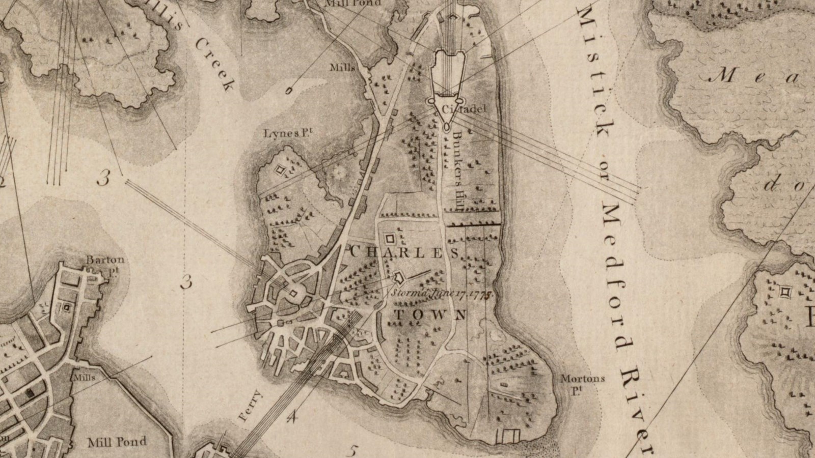
Bunker Hill
Leventhal Map & Education Center
Quick Facts
Location:
Charlestown
Significance:
Site of the Battle of Bunker Hill during the Siege of Boston
With an elevation of 110 feet, Bunker Hill is one of the tallest hills near Boston. Like other hills around Boston, Bunker Hill is a drumlin, or elongated hill, formed by a retreating glacier eons ago. George Bunker, an early resident of colonial Charlestown, once owned the land that included this hill. Provincials used Bunker Hill for agricultural purposes.
In the aftermath of the Battle of Lexington and Concord in April 1775, the Provincials, or colonial forces, looked at Bunker Hill and other hills as military positions. These hills provided high ground with panoramic views and placements for cannon. Provincials planned a Siege of Boston to drive out the British military that had been in Boston since 1774 as part of the British Coercive Acts.
British military leaders in Boston saw the advantage of occupying both Bunker Hill, located north of Boston, and Dorchester Heights, located in the south, to break the Siege of Boston. Before the British could act, the Provincials took Bunker Hill for themselves on the night of June 16, 1775.
A Provincial force of about 1,000 militiamen took Bunker Hill and built a redoubt, or earthen fort, on the adjacent smaller hill, sometimes called Breed's Hill. People have since debated the decision to build a redoubt on Breed's Hill rather than the more prominent Bunker Hill but both hills played a role in the Battle of Bunker Hill.
In the early hours of June 17, 1775, the British Navy tried to dislodge the Provincials from their redoubt on Breed's Hill with a two-hour barrage of cannon fire from ships in Boston Harbor. This failed and over 2,000 British Regulars tried to remove the Provincials from both hills. The Regulars ferried across the harbor from Boston to Charlestown.
The Provincials built an elevated, fortified position that spread across sections of both Bunker and Breed’s Hills. With effective musket fire volleys, the Provincials drove back two assaults by the British Regulars. The Regulars pursued a third assault that dislodged the Provincials from both Breed's Hill and Bunker Hill. The British victory came at a big cost as they suffered over twice the casualties as the Provincials. Also, the Siege of Boston to drive out the British remained intact.
Nearly fifty years after the Battle of Bunker Hill, people from Boston and beyond became inspired to formally commemorate the battle. The Bunker Hill Monument Association (BHMA) formed in 1823 with the goal of preserving the battlefield and building a monument. The BHMA decided to build the Bunker Hill Monument on Breed's Hill since that is where most of the Provincials died.
It took over fifteen years to complete the monument, mainly due to the unexpected cost of the endeavor. In 1840, the BHMA almost resigned itself to a 160-foot monument, until Sarah Josepha Hale offered to run a week-long fair in Boston’s Quincy Market. Hale's "Ladies' Fair" raised the large sum of $30,000 and with other last-minute contributions, the 221-foot obelisk was completed in 1842.
The BHMA owned and managed the Bunker Hill Monument and its surrounding four acres for nearly seventy-five years but passed the complex over to the Commonwealth of Massachusetts in 1919. As the mid-1970s approached, BHMA members, local, state, and federal officials decided that the National Park Service take over this significant national site as the nation’s Bicentennial approached in 1976. The Bunker Hill Monument became part of the National Parks of Boston in 1975. It became a stop on the Freedom Trail in 1977.
Today, Bunker Hill is a residential area with a church on top of the hill. Bunker Hill still offers a great panoramic view of the surrounding area.