Last updated: March 10, 2025
Place
Lewis and Clark Enter into Louisiana Purchase
Library of Congress
Quick Facts
Location:
US-60 &, US-62, Cairo, IL 62914
Significance:
This is the location of the confluence of the Ohio and Mississippi Rivers. Meriwether Lewis and William Clark passed through here in 1803 on their way into lands ceded to the United States from France as part of the Louisiana Purchase.
Designation:
Lewis and Clark National Historic Trail
Amenities
10 listed
Electrical Hookup - Boat/RV, Historical/Interpretive Information/Exhibits, Information Kiosk/Bulletin Board, Parking - Auto, Parking - Bus/RV, Picnic Shelter/Pavilion, Picnic Table, Scenic View/Photo Spot, Tent Campsites, Toilet - Vault/Composting
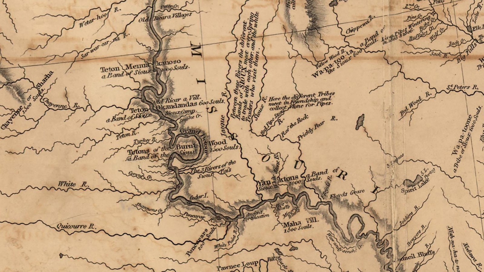
European powers based their claims to the Louisiana Territory on a European legal theory called the “Doctrine of Discovery.” The first European nation to “discover” lands unknown to them could then lay claim to those lands.
The Doctrine of Discovery minimized the right of Indigenous people to their own lands. It only allowed Indigenous communities to retain a so-called “native title.” This meant they could occupy and use, but not own, their own homelands. It still required Europeans to negotiate treaties with Indigenous leaders to fully take over their land.
The French first claimed the territory west of the Mississippi River in 1682 and called it La Louisiane after King Louis XIV. French settlers knew about Indigenous nations who had lived, farmed, and hunted near great cities like Cahokia for millennia, but according to the rules that the European leaders wrote, Indigenous claims were not as valid as those of these new arrivals.
France, Britain, Spain, and eventually, the new United States of America, vied for and divided up this land that had been occupied by many people since time immemorial. This back and forth culminated in 1803, when the United States agreed to pay France $15 million for 818,000-square-miles of territory west of the Mississippi River that France claimed. With this purchase complete, the U.S. government could negotiate directly with Indigenous communities for their lands.
One of President Thomas Jefferson’s main goals for the Lewis and Clark Expedition was to establish contact with as many Indigenous people as they could and understand “the extent & limits of their possessions.” Once armed with this information, the United States could take these lands, either through treaty or through force.
For Indigenous people west of the Mississippi River, the Louisiana Purchase was the beginning of a hundred years of land loss, forced relocation, and threats to traditional lifeways.
About this article: This article is part of series called “Pivotal Places: Stories from the Lewis and Clark National Historic Trail.”
Lewis and Clark NHT Visitor Centers and Museums
This map shows a range of features associated with the Lewis and Clark National Historic Trail, which commemorates the 1803-1806 Lewis and Clark Expedition. The trail spans a large portion of the North American continent, from the Ohio River in Pittsburgh, Pennsylvania, to the mouth of the Columbia River in Oregon and Washington. The trail is comprised of the historic route of the Lewis and Clark Expedition, an auto tour route, high potential historic sites (shown in black), visitor centers (shown in orange), and pivotal places (shown in green). These features can be selected on the map to reveal additional information. Also shown is a base map displaying state boundaries, cities, rivers, and highways. The map conveys how a significant area of the North American continent was traversed by the Lewis and Clark Expedition and indicates the many places where visitors can learn about their journey and experience the landscape through which they traveled.