Last updated: October 5, 2022
Place
Los Alamos Wayside: Now We Have Our Bomb
NPS
Quick Facts
Location:
Kwage Mesa Trail
MANAGED BY:
Amenities
1 listed
Historical/Interpretive Information/Exhibits
Main Text
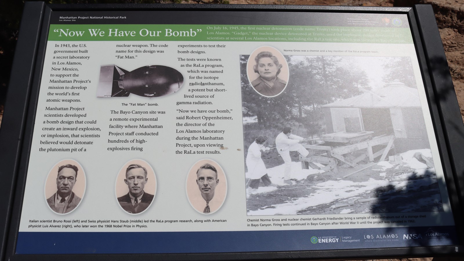
Now We Have Our Bomb – On July 16, 1945 the first nuclear detonation (code name Trinity) took place about 200 miles south of Los Alamos. “Gadget,” the nuclear device detonated at Trinity used the implosion design developed by scientist at several Los Alamos locations, including the RaLa test site, which was located in Bayo Canyon.
In 1943, the U.S. government built a secret laboratory in Los Alamos, New Mexico, to support the Manhattan Project’s mission to develop the world’s first atomic weapons. Manhattan Project scientist developed a bomb design that could create an inward explosion, or implosion, that scientists believed would detonate the plutonium pit of a nuclear weapon. The code name for this design was “Fat Man.” The Bayo Canyon site was a remote experimental facility where Manhattan Project staff conducted hundreds of high-explosives firing experiments to test their bomb-designs. The test were known as the RaLa program, which was named for the isotope radiolanthanum, a potent but short-lived source of gamma radiation. “Now we have our bob,” said Robert Oppenheimer, the director of the Los Alamos laboratory during the Manhattan Project, upon viewing the RaLa test results.
Exhibit Panel Description
A black band at the top of the wayside says, “Manhattan Project National Historical Park Los Alamos, New Mexico” On the right of the black band is the National Park Service log o and the U.S. Department of Energy logo. Below the black band a green band has the title of this wayside, “Now We Have Our Bomb.” In the text is an image of a bomb, that is rounded on one end and square on the other. The text below the image reads, “The “Fat Man” bomb.” Below the text are pictures of three white men wearing suits and ties in three individual oval shapes. The text below the ovals reads, “Italian scientist Bruno Rossi (left) and Swiss physics Hans Staub (middle), along with American physics Luis Alvarez (rights, who later won the 1968 Nobel Prize for Physics. On the right side of the wayside a large black and white image of two people pulling a wooden structure out of the building. Text below the image reads, ”Chemist Norma Gross and nuclear chemist Gerhardt Friedlander bring a sample of radiolanthanum out of a storage shed in Bayo Canyon. Firing test continued in Bayo canyon after World War II until the project was cancelled in 1962.” At the top of the image an oval with the black and white image of a women wearing a dark jacket. Text next to the oval reads, “Norma Gross was chemist and key member of the RaLa program team.” A blue bar at the bottom has “U.S. Department of Energy | Legacy Management, Los Alamos Where Discoveries Are Made, NNSA, and Los Alamos National Laboratory.”
Visit This Exhibit Panel
This wayside is located along the Kwage Mesa Trail. The Kwage Mesa stretches out on the north side of Los Alamos. To get to the trailhead from 15th Street and Central Avenue in downtown Los Alamos, head west (towards the Jemez Mountains) on Central. In 0.8 miles (1.28 km), past Ashley Pond, and the Aquatic Center, turn right onto Diamond Drive. Pass the Los Alamos High School and the Los Alamos Golf Course to the San Ildefonso roundabout located 2.4 miles (3.86 km) from the intersection of Central and Diamond. Bear right on San Ildefonso. Head south, then east on this road, passing the Los Alamos Middle School. About 0.1-mile (0.16 km) past North Mesa Road on the left, turn left onto an unnamed road heading toward the stable area. The road swings to the right and ends at a parking area at the North Mesa Tennis Courts. The trailhead is on the left of the playlot.