Last updated: November 28, 2023
Place
Pompeys Pillar, Montana
BLM Flickr Account
Quick Facts
Location:
3039 US Highway 312, Pompeys Pillar, MT 59064
Significance:
Lewis and Clark National Historic Trail
Designation:
In 1806, William Clark carved his name into a sandstone outcropping next to the Yellowstone River, next to petroglyphs that the Crow and other Indigenous people had carved on these rocks for thousands of years.
MANAGED BY:
Amenities
12 listed
Gifts/Souvenirs/Books, Historical/Interpretive Information/Exhibits, Information - Ranger/Staff Member Present, Parking - Auto, Parking - Bus/RV, Picnic Table, Restroom, Restroom - Accessible, Scenic View/Photo Spot, Trailhead, Trash/Litter Receptacles, Wheelchair Accessible
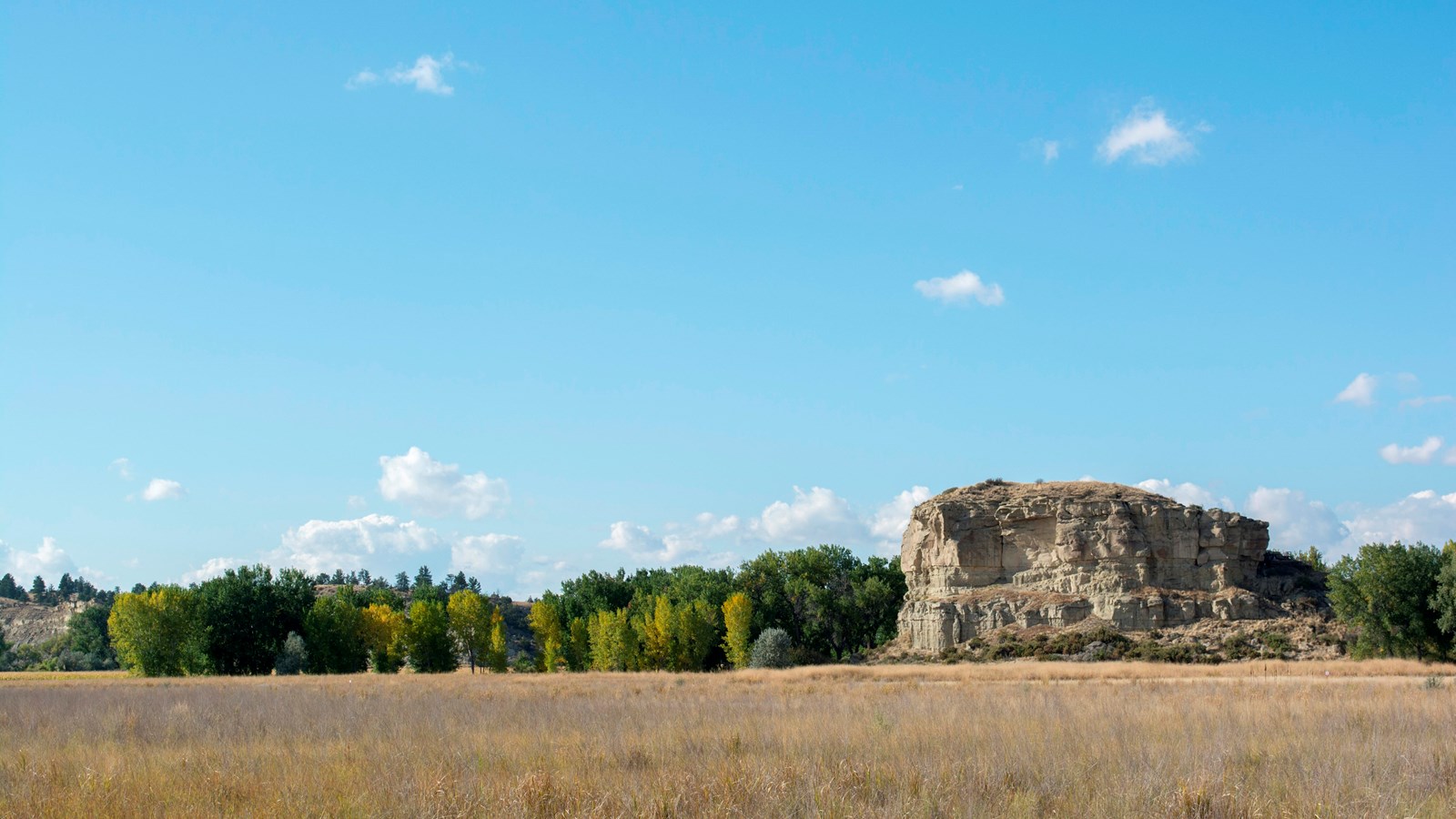
This sandstone outcropping next to the Yellowstone River has been a sacred site to the Crow since time immemorial. They called it, among other names, Iishbiiammaache, roughly translated as the “Mountain Lions Lodge.”
People who passed through here, whether Crow, Shoshone, Sioux, Cheyenne, Arapaho, Blackfeet or Salish, carved images, also known as petroglyphs, into the soft sandstone walls.
William Clark, Sacagawea, her son Jean Baptiste Charbonneau, York (a Black man enslaved by Clark), and five other men passed this rock in 1806, while traveling along the Yellowstone. They stopped their boats and climbed up the rock formation.
Clark named the site Pomp’s Tower, after his nickname for one-year-old Jean Baptiste. Clark then scratched his name and the date of his visit, July 25, 1806, into the rock, next to petroglyphs that had been carved by Indigenous people for thousands of years.
Why did he want to write his name in the rock?
Clark had written his name at other places during the journey. Both he and Meriwether Lewis carved their names on trees at Cape Disappointment and near Fort Clatsop. Maybe that was partly for fun, to satisfy that urge to leave your mark, but that carving may have also been to prove that they had made it to the Pacific Ocean. According to the European legal theory the “Doctrine of Discovery,” proving that you had been somewhere could help you claim to own it down the road—but only if you were White.
At Iishbiiammaache, Clark was just one of many people to pass through this spot. He may have been writing his name to stake a claim, or he may have just wanted to add his mark to the many who came before him.
About this article: This article is part of a series called “Pivotal Places: Stories from the Lewis and Clark National Historic Trail.”
Lewis and Clark NHT Visitor Centers and Museums
This map shows a range of features associated with the Lewis and Clark National Historic Trail, which commemorates the 1803-1806 Lewis and Clark Expedition. The trail spans a large portion of the North American continent, from the Ohio River in Pittsburgh, Pennsylvania, to the mouth of the Columbia River in Oregon and Washington. The trail is comprised of the historic route of the Lewis and Clark Expedition, an auto tour route, high potential historic sites (shown in black), visitor centers (shown in orange), and pivotal places (shown in green). These features can be selected on the map to reveal additional information. Also shown is a base map displaying state boundaries, cities, rivers, and highways. The map conveys how a significant area of the North American continent was traversed by the Lewis and Clark Expedition and indicates the many places where visitors can learn about their journey and experience the landscape through which they traveled.