Last updated: March 14, 2024
Place
"President Roads" Sign
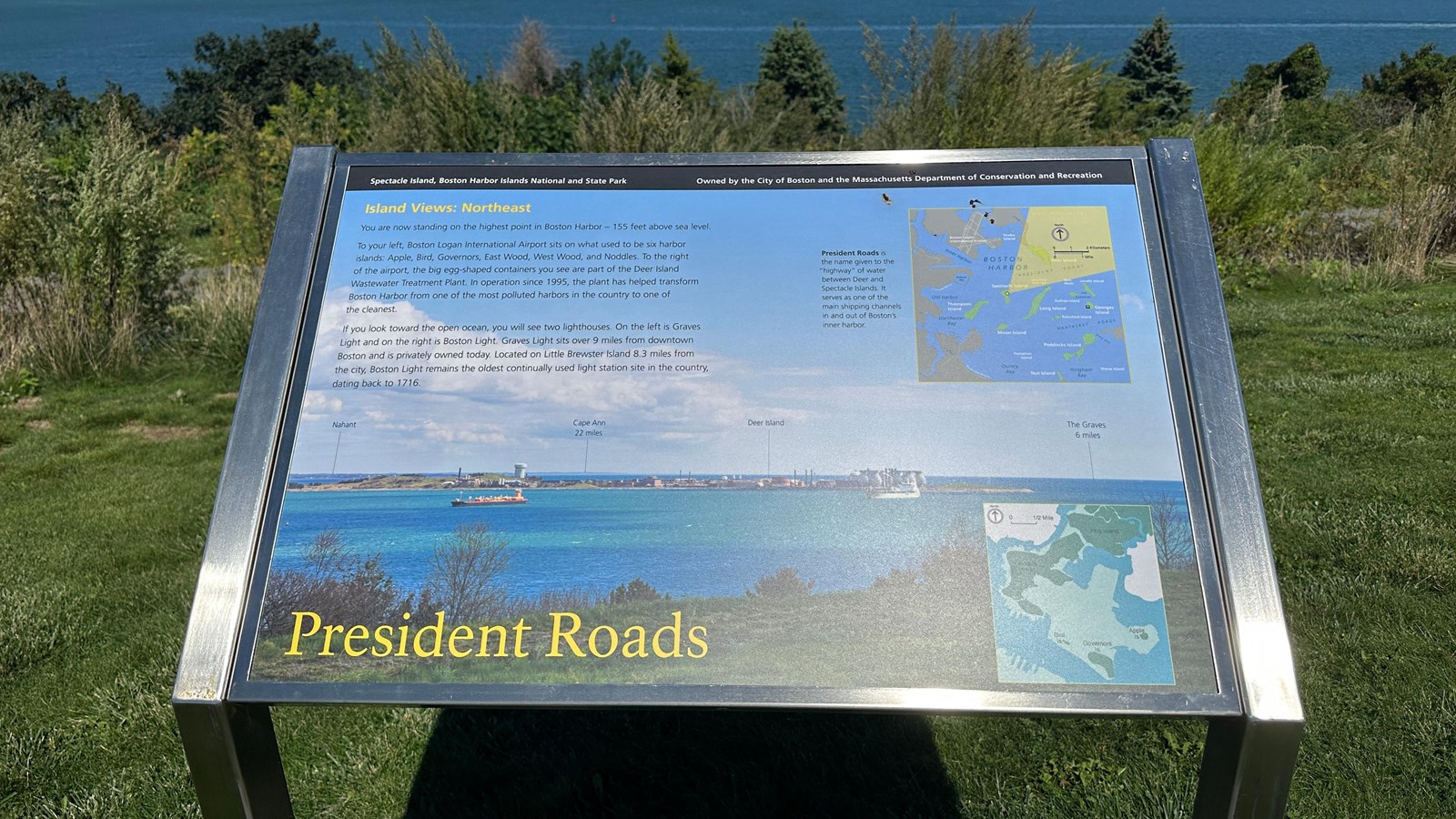
NPS Photo/M Mark
Quick Facts
Location:
Spectacle Island
Amenities
1 listed
Historical/Interpretive Information/Exhibits
Description
Low-profile wayside that is 36 x 24 inches, with interpretation panel spanning 36.5 inches wide. It has a grey square base with two rectangular pillars supporting the panel. The panel is framed in grey metal. The sign is located on the interpretive trail on the North Drumlin.
Layout
At the top of the sign is a black banner with white text. Aligned to the left is text that reads “Spectacle Island, Boston Harbor Islands National and State Park.” Aligned to the right is text that reads “Owned by the City of Boston and the Massachusetts Department of Conservation and Recreation.” The section of text is titled, “Island Views: Northeast” in yellow text aligned to the left just underneath the black banner. The panel’s background captures a view towards Deer Island with a grassy slope in the foreground before it drops off to bright blue water with a few cargo ships carrying shipping containers. Behind the cargo ships is Deer Island, which has a sewage plant composed of white, egg-shaped facilities. On the left of the panel, under the title, is a column of text broken up into 2 paragraphs. On the right is one illustrated map in the top right with a caption next to it, and beneath it is a slightly smaller map. At the bottom of the panel the title reads “President Roads” in yellow text.
Image Description (upper right)
An illustrated map of Boston Harbor featuring East Boston, Downtown Boston, South Boston, and Dorchester’s land masses that make up the Boston coastline in white. The Harbor Islands are all depicted in green with their names in white text. Islands included (from approximately north to south): Snake Island, Deer Island, Long Island (with Long Island Head Light labeled on the north edge of the island), Nixes Mate, Lovells Island, Spectacle Island, Gallops Island, Georges Island, Thompson Island, Rainsford Island, Moon Island, Peddocks Island, Hangman Island, Nut Island, and Sheep Island. Georges Island has a small white question mark in a black box indicating a visitor’s center. “Boston Harbor” is labeled in dark blue in the center. On land “Boston Logan International Airport” is labeled and in lighter gray has the runways outline. On the landmass just across the inner harbor, the bridges from Boston to Charlestown are highlighted in a light grey, but remain unlabeled. Other water features going down the coastline are labeled in the same dark blue: “Inner Harbor,” “Pleasure Bay,” “Old Harbor,” “Dorchester Bay,” and “Quincy Bay.” Two beaches on the coastline are labeled in white, the first is above Old Harbor “L Street Beach” and the second is in Quincy Bay, “Wollaston Beach.” Out in the harbor, “President Roads,” between Deer Island and Long Island, is labeled in dark blue, along with “The Narrows” between Gallops Island and Lovells Island. Also labeled in dark blue is “Nantasket Roads” between Peddocks Island and Rainsford Island and Georges Island to the north, as well as “Hull Gut” between Peddocks and an outstretch of land that is presumably Hull. Beneath the harbor islands, at the bottom of the map “Quincy Bay” and Hingham Bay are labelled, with “Hull Gut” labeled on an outstretch of land that is presumably Hull. The top right of the map is labeled “Massachusetts Bay” in a light blue with an arrow pointing upwards in a grey circle that indicates “North.” Underneath the arrow is a graphic depicting the scale of the map. Underneath the arrow is a small-scale image, depicting the scale of the map, on top it has 2 kilometers labeled in black, and 1 mile labeled in white. On Spectacle Island there is a yellow dot which has a triangulated yellow field showing the field of vision from that spot on Spectacle Island. Within this yellow field it includes Deer Island, President Roads passage, Nixes Mate, and the edge of Long Island. It also obscures the Massachusetts Bay label.
Image Caption
President Roads is the name given to the “highway” of water between Deer and Spectacle Islands. It serves as one of the main shipping channels in and out of Boston’s inner harbor.
Image Description (lower right)
Illustrated map of Hog Island, Noddle’s Island, Bird Island, Governors Island, and Apple Island. The current Boston coastal landmass around them is in white and the islands themselves, are dark green, labeled (from north to south): “Hog Island,” “Noddles Island,” “Bird Is,” “Governors Is,” and “Apple Is.” The historical islands have a green shadow outlined around them showing the shape of Boston Logan International Airport. Also in green is a cut out of downtown Boston landmass, indicating it was also filled in. In the top left is an arrow pointing up in a grey circle labeled “North.” Next to it is a map scale with 0 and ½ mile at each end indicated by a bracket.
Image Description (background)
Photo looking out from the North Drumlin of Spectacle Island across the water to Deer Island. The foreground has green grass and scrubby bushes before dropping off into sparkling blue water. The sky is light blue with fluffy clouds. The channel has two cargo ships in it. The ship in the left third of the image is black with yellow and red containers and equipment on top. A white ship moves in the channel in the right third. Behind the ships is Deer Island. Looking from left to right, a few small green hills surrounded by brown dirt/brushy areas that leads to small white buildings with one big dome shaped building. Continuing along, small square brown buildings have some spouts/poles jutting upwards before culminating about two/thirds of the way across the photo with white egg-shaped structures that are in sets of two. About 6 of these structures are visible. To the right is a small grassy area that leads to the beach before it is surrounded by water. Behind the buildings is more blue water with land barely visible in the far distance, looking like a shadow. The photo is labeled, left to right, with “Nahant” pointing to the land mass in the far distance, “Cape Ann 22 miles” pointing to the landmass in the far distance, “Deer Island” pointing to the land mass in the midground, and then in the far right in the distance of the outer harbor “The Graves 6 miles.”
Main Text
You are now standing on the highest point in Boston Harbor – 155 feet above sea level.
To your left, Boston Logan International Airport sits on what used to be six harbor islands: Apple, Bird, Governors, East Wood, West Wood, and Noddles. To the right of the airport, the big egg-shaped containers you see are part of the Deer Island Wastewater Treatment Plant. In operation since 1995, the plant has helped transform Boston Harbor from one of the most polluted harbors in the country to one of the cleanest.
If you look towards the open ocean, you will see two lighthouses. On the left is Graves Light and on the right is Boston Light. Graves Light sits over 9 miles from downtown Boston and is privately owned today. Located on Little Brewster Island 8.3 miles from the city, Boston Light remains the oldest continually used light station in the country, dating back to 1716.