Last updated: November 8, 2024
Place
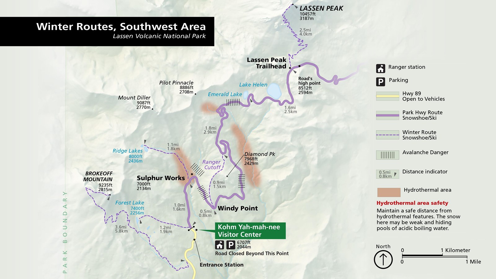
Southwest Area Winter Routes
NPS map
Quick Facts
Amenities
2 listed
Parking - Auto, Trailhead
Lassen’s southwest area tends to receive more snow, has steeper slopes, and an increased risk of avalanches compared to the Manzanita Lake area. The parking area for southwest routes is at the Kohm Yah-mah-nee Visitor Center; the park road is closed to vehicle traffic beyond this point. The visitor center offers the only visitor services during winter months.Learn more about winter safety before starting your adventure.
Beginner Routes
Sulphur Works Hydrothermal Area
Distance: 2 miles (3.2km) roundtrip
Elevation: 6700 to 7000 feet
Average Skiing Time: 1 hour
From the parking area, follow the park highway route 1 mile (1.6km) to the Sulphur Works viewing area. The left side of the route is bordered by steep side hills; there is a small avalanche-prone slope. Return along same route.
Hydrothermal Area Safety: Maintain a safe distance from hydrothermal features. The snow surrounding these areas may look solid but can be a weak layer hiding pools of acidic boiling water. Visitors have been severely burned by hot mud and water.
Intermediate Routes
Ridge Lakes
Distance: 4 miles (6.4km) roundtrip
Elevation: 6700 to 8000 feet
Average Skiing Time: 4 hours
From the parking area, follow the park highway route about ¾ mile (1.2km), crossing the bridge before Sulphur Works. There is a flat area to the left (Sulphur Works parking area) – the Ridge Lakes route begins at the far/north end of this flat area. The route climbs rapidly along the east side of West Sulphur Creek to the Ridge Lakes basin (1.1mi/1.8km). Return along same route.
Backcountry Camping: Several good camping spots can be found on the north shore of Ridge Lakes. If weather is severe, more protected camping can be found about ¼ mile below Ridge Lakes along its outlet creek. Avoid the area south of Ridge Lakes during periods of increased avalanche danger.
Hydrothermal Area Safety: Maintain a safe distance from hydrothermal features. The snow surrounding these areas may look solid but can be a weak layer hiding pools of acidic boiling water. Visitors have been severely burned by hot mud and water.
Diamond Peak
Distance: 4 miles (6.4km) roundtrip
Elevation: 6700 to 8000 feet
Average Skiing Time: 4 hours
From the parking area, follow the park highway route 1.5 miles (2.4km) to Windy Point. Veer left at the marker for the Ranger Cutoff just beyond the point. The route climbs a gentle slope to a ridge with excellent views of Brokeoff Mountain and Sulphur Works. Stop here or continue along the ridge as it gradually narrows, providing views of Lassen Peak and eventually opening onto a steep slope at the western foot of Diamond Peak (~0.5mi/0.8km). Return along same route to avoid avalanche-prone slopes above Sulphur Works and along the park highway route north of Windy Point.
Advanced Routes
Travel outside of the highway corridor is recommended only for experienced winter travelers.
Brokeoff Mountain
Distance: 7 miles (11.3km) roundtrip
Elevation: 6650 to 9250 feet
Average Skiing Time: 8 hours
Traditional routes use the Forest Lake route (near parking area) or the summer trail that begins near the park entrance. Numerous avalanche paths exist on all aspects of the mountain. Travelers should use extreme caution. Many skiers reserve travel to the summit for spring when snow conditions traditionally stabilize. Summit conditions during inclement weather often include high winds with little or no visibility. Be cautious of overhanging cornices at the summit.
Lassen Peak
Distance: 17 miles (27.4km) roundtrip
Elevation: 6700 to 10457 feet
Average Skiing Time: 3 days
Most travelers allow three days to summit Lassen Peak in the winter. Be prepared for high winds in the Lassen Peak and Lake Helen areas. Conditions on the mountain are most stable in early morning hours; afternoon travel is not recommended. The safest route up the mountain follows the summer trail through the forested section and continues on the southeast ridge to the summit. Weather conditions on Lassen Peak can deteriorate rapidly, creating white out conditions and high winds.It is advised to travel the Ranger Cutoff to avoid the road corridor skirting the base of Diamond Peak which is prone to avalanche. Travel beyond Ranger Cutoff may be impassable due to snow-drifted areas along the Emerald Sidehill.