An official website of the United States government
Here's how you know
Official websites use .gov A
.gov website belongs to an official government
organization in the United States.
Secure .gov websites use HTTPS A
lock (
) or https:// means you've safely connected to
the .gov website. Share sensitive information only on official,
secure websites.
Lower elevations are usually sunny and hot while higher elevations can be cool in mornings and evenings. Prepare for both before you visit the parks!
NPS Photo / Rebecca Stievater
Summer in the Sequoia Groves
If you plan to visit the sequoias, be prepared for warm daytime temperatures and cool conditions in the mornings and evenings by bringing clothing for both warm and cold weather.
The lower-elevation foothills can be quite hot during the day. Most campgrounds are open and camping is by resrevatyion only. Some side roads will have some minor construction at one time or another during the summer.
To stay updated on the many changes occurring during this period of transition, read through our tips and tricks below!
Weather
Check the weather forecast before you head out! Summer is a wonderful time to visit giant sequoias, but only when you are prepared for the conditions. Plan ahead by packing multiple layers of clothing so that you can adjust to warmer or cooler conditions.
Air Quality
The dial below represents the current Air Quality Index (AQI) for the Sequoia and Kings Canyon National Parks' reporting area near the Foothills Visitor Center. Local conditions within the parks can vary to be worse or better than what is indicated. In summer months, ozone concentrations often exceed federal health standards. Ozone can have negative health effects. Learn more about air quality and how it can impact your trip.
Note: This is an old image from the webcam that may not represent the current conditions in the park. For an updated view of the Giant Forest, please click the link in the text about the webcam.
Sequoia National Park Webcam
The Giant Forest webcam looks west from the edge of the Giant Forest. In summer, a gray layer of polluted air can be seen forming over the valley. Rarely can you see both the San Joaquin Valley and the Coast Range beyond that. With increasing air pollution blowing up into the Sierra Nevada from the Bay Area and the Valley, very clear days are becoming ever more rare.
Note: The adjacent image is from the past and may not represent the current conditions in the park. For an updated view of the Giant Forest, please click the link below.
Almost all roads are open. If you're considering visiting some areas accessed by small side roads, check our road conditions page before you head into the parks. We always recommend checking operating hours before arriving.
Wood and charcoal fires (including wood-burning stoves) are prohibited in all developed campgrounds below 3,000 feet (914 m) elevation (South Fork, Potwisha, and Buckeye Flat).
Wood and charcoal fires (including wood-burning stoves) are prohibited in Hospital Rock picnic area and AshMountain picnic area next to Foothills Visitor Center.
Smoking is prohibited below 6,000 feet (1829 m) elevation, except within an enclosed vehicle, a building in which smoking is allowed, a campground or picnic area where wood and charcoal fires are allowed, or a designated smoking area.
Wood and charcoal fires (including wood-burning stoves) are prohibited below 6,000 feet (1829 m) elevation in backcountry undeveloped campsites.
Weather
Days are warm to hot and evenings and mornings are cool in the Foothills. Pack for a range of weather conditions when visiting. Dress appropriately and always bring plenty of water.
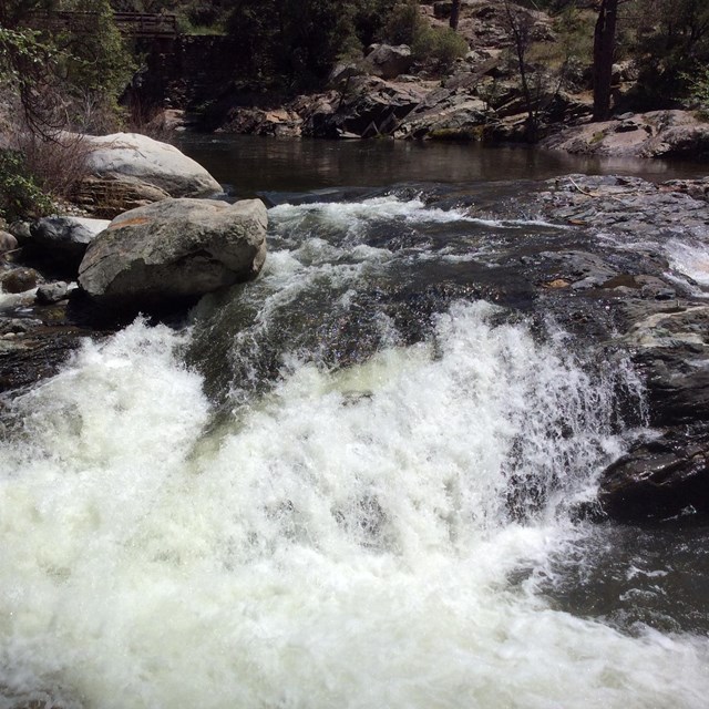
River Safety
Drowning is the primary cause of death in the parks. View the rivers from a distance. The water is very cold and swift. Rocks near the river are slippery. The soil near and along the rivers can be unstable. It can collapse unexpectedly under the weight of people, including children, and result in falls into the river. Learn more about river safety
Trails
Check the Foothills Trails page for ideas to help you plan your trip.
Potwisha Campground is open. Wood and charcoal fires are prohibited. Reservations are required. Visit recreation.gov to reserve your campsite.
Buckeye Flat Campground is closed for 2026 due to damage from past winter storms.
South Fork Campground is closed and not accessible due to damage from flooding and landslides from past winter storms. At this time, it is unknown when or if the campground will re-open.
Free Ranger Programs
A schedule of ranger-led programs is available on our events calendar. *Ranger programs are posted online at least one week in advance.
Weather
Check weather forecasts. Temperatures in the sequoia groves and the mountains are cooler than temperatures in the Central Valley and the Sierra foothills. Temperatures are coldest in the mornings and evenings. Storms in the area can still produce cold rain and snow. Bring extra layers of clothing to be prepared for all weather conditions. As always, make sure to protect yourself with sunscreen, a hat, and plenty of water.
Overnight lodging and food service offered. See visitsequoia.com for more information.
Free Shuttles in the Giant Forest - Sherman Tree - Lodgepole Areas
Parking throughout the Giant Forest area, espcially near the General Sherman Tree, is limited. Park your car at one of the larger parking lots and use the Fare-free shuttles to get around.
Expect parking at the Giant Forest Museum and General Sherman Tree to fill early on weekends and holidays.
Arriving late morning or midday? Park at one of the outer parking lots--Wuksachi Lodge or Lodgepole Campground--and use the fare-free shuttles to get around the Giant Forest and access the General Sherman Tree.
Trails
Trails within the Giant Forest and Lodgepole areas are open.
Camping
Lodgepole Campground is open for the season. Lodgepole is the most popular campground in the parks and site availability may be extremely limited, especially on weekends and holidays. Reservations must be made in advance through recreation.gov.
Dorst Creek Campground is closed in 2026.
Lodgepole Concessions
Lodgepole Market has a large selection of supplies and services, including clothing, groceries, grab-and-go food, and an ATM. Lodgepole Grill offers casual food including burgers, sandwiches, salads, and snacks. Showers and laundry facilities are also available.
Market: OPEN
Lodgepole Grill: OPEN
Showers, Laundromat: OPEN
Free Ranger Programs
A schedule of ranger-led programs is available on our events calendar. *Ranger programs are posted online at least one week in advance.
There will be construction on Mineral King Road in late summer 2026. A schedule of traffic impacts will be posted on our Road Construction page.
Wilderness Permits
Wilderness permits are available at the Mineral King Ranger Station.
Facilities
Some facilities may have limited hours.
Campgrounds
All campgrounds are reservation only. See the Campgrounds page for more details.
Weather
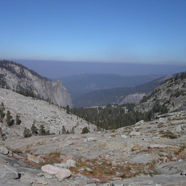
Between 7,500 to 14,000 feet elevation, Mineral King is characterized by mild daytime temperatures and cold nighttime and morning temperatures. Check weather forecasts.
Weather
Check weather forecasts. Temperatures in the sequoia groves and the mountains are lower than California's Central Valley and the Sierra foothillls. Temperatures are cool in the mornings and evenings. Storms in the area can bring cold rain and some can still produce wet snow. Bring extra layers of clothing to be prepared for all weather conditions. As always, make sure to protect yourself with sunscreen, a hat, and plenty of water.
Trails within the Grant Grove area are open. Check at the Kings Canyon Visitor Center for the most up-to-date trail conditions.
Only 2.5 miles of trails in the Redwood Canyon area are maintained. Traveling on unmaintained trails is not advised due to tree hazards following damage from the 2021 KNP Complex Fire.
Camping
All camping is by reservation only, through recreation.gov.
Azalea Campground is open. During spring, summer, and fall, camping is by reservation only. During the winter, part of the campground is open on a first-come, first-served basis.
Crystal Springs Campground is open for the season.
Sunset Campground is open for the season.
During the spring, summer, and fall, most campgrounds fill well in advance of weekends and holidays. Reservation windows vary between campgrounds, see each individual campground page or recreation.gov for more information.
Free Ranger Programs
A schedule of ranger-led programs is available on our events calendar. *Ranger programs are posted online at least one week in advance.
The road to the Cedar Grove area is typically open from May through early to mid-November. Opening and closing dates may change depending on weather and conditions.
Check weather forecasts. As always, pack for a range of weather conditions. Be prepared for cool evening and morning temperatures and warm daytime temperatures. As always, make sure to protect yourself with sunscreen, a hat, and plenty of water.
During the backcountry permit quota period that begins on May 22, wilderness permits are available at the Road's End Ranger Station.
Visitor Center
Cedar Grove Visitor Center is open.
Camping
Camping is by reservation only. All campgrounds are open.
During the late spring, summer, and fall, most campgrounds fill well in advance of weekends and holidays. Reservation windows vary between campgrounds, see each individual campground page or recreation.gov for more information.
Cedar Grove Concessions
Cedar Grove Market has a large selection of supplies and services, including clothing, groceries, and grab-and-go food. Cedar Grove Grill offers casual food including burgers, sandwiches, salads, and snacks. Showers and laundry facilities are also available here.
Cedar Grove Lodge (overnight accommodations): OPEN
Market and Grill: OPEN
Showers, Laundromat: OPEN
Free Ranger Programs
When the Cedar Grove Visitor Center is open, Ranger-led programs are often available. When programs are offered, the schedule of ranger talks and programs are posted on our events calendar. *Ranger programs are posted online at least one week in advance.
Map of Trail and Area Closures at Sequoia and Kings Canyon National Parks
Click on a line or point for the name of the closed location.
Trail closures are shown in red.
Individual point closures are shown with black pins.
Area closures are shown in yellow.
Closures can change at any time and may differ from what is shown on this map. For detailed information on road closures, please visit the Road Conditions page.