
Photograph by John Dvorak, 1980, USGS.
Introduction
Directed blasts are generated by massive explosions during volcanic eruptions. The USGS defines a directed blast as “a hot, low-density mixture of rock debris, ash, and gases that moves at high speed along the ground surface.” Lateral blasts have a significant low-angle component.
Because they carry rock debris at high speeds, directed blasts can devastate areas tens to hundreds of square miles within a few minutes. They can also destroy manmade structures and kill all living things by abrasion, impact, burial, and heat. As a result, they are one of the most dangerous and destructive of all volcanic processes.
Mt St. Helens 1980 Lateral Blast
The best-known and most-studied directed blast in the history of volcanology is lateral blast at the start of the climatic May 18, 1980 Mt. St. Helens eruption.

USGS image by Gary Rosenquist.
The St. Helens lateral blast was triggered by an earthquake and consequent debris avalanche as the north side of the mountain gave way. The sudden decrease of pressure and a steam explosion propelled the lateral blast, which was in turn quickly followed by a Plinian eruption.
Mt. St. Helens’ lateral blast devastated an area of 230 square miles (600 square km), and blew down wide swaths of forest, splintering and snapping some tree like matchsticks. The blast travelled at speeds up to 670 mph (1080 k/hr), and left a thin deposit of warm rock fragments and ash.
Lassen Peak May 1915 Directed Blasts
At least two directed blasts occurred during the 1915 eruptions at the Lassen volcanic complex, although they were much smaller than the Mt. St. Helens lateral blast.
First Blast—Before and After
Overnight on May 19, 1915, a blast disrupted a dacite dome growing in the crater. It blew down trees on the northeast side of the volcano and generated a debris avalanche and lahar.
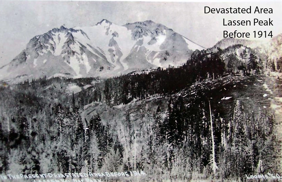

Left image
The view from the Devastated Area in 1914, before the May 1915 cataclysmic eruptions.
Credit: USGS photo.
Right image
View showing the devastation of the May 19 eruption, including area of tree blow-downs, debris avalanche and lahar. The rock labeled “Hot rock” was still warm to the touch when the photograph was taken on May 22.
Credit: USGS photo.
Second Blast—Before and After
Late in the afternoon of May 22, a second larger directed blast blew out a larger crater at the summit. This eruption sent a column 30,000 feet (9,000 m) into the atmosphere, and generated a pyroclastic flow and lahar.
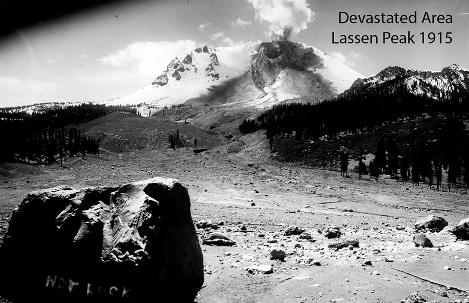

Left image
View showing the devastation of the May 19 eruption, including area of tree blow-downs, debris avalanche and lahar. The rock labeled “Hot rock” was still warm to the touch when the photograph was taken on May 22.
Credit: USGS photo.
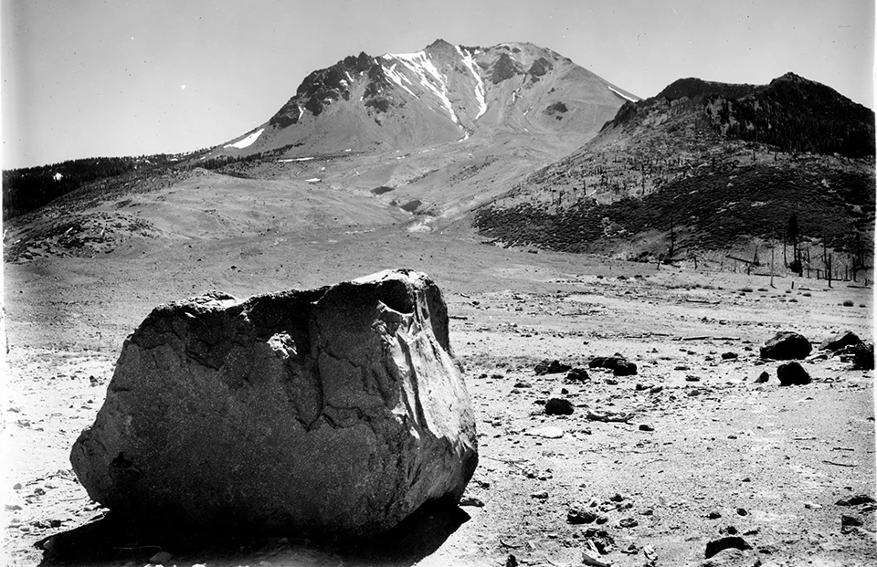
Right image
Photograph taken after the climatic May 22 eruption showing a larger area of devastation.
Credit: USGS photo.
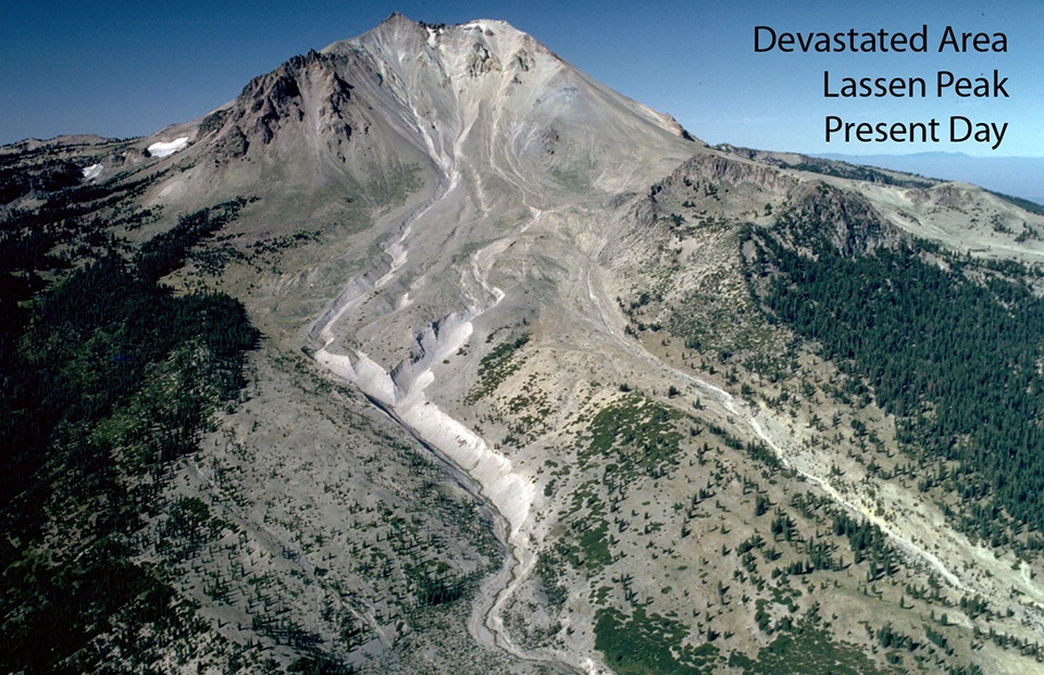
Devastated Area—80 Years Later
The 3-square-mile (8-square km) Devastated Area in Lassen Volcanic NP is the result of the May 1915 eruptions, and today is the site of a short interpretive trail that introduces park visitors to the effects of the Lassen Peak eruptions.
Left image
Photograph taken after the climatic May 22 eruption showing a larger area of devastation.
Credit: USGS photo.
Right image
Lassen Peak's Devastated Area photographed from the air in 1994.
Credit: USGS photo.
Devastated Area Map

Illustration modified from USGS.
Related Links
-
Lassen Volcanic National Park (LAVO), Califorina—[LAVO Geodiversity Atlas] [LAVO Park Home] [LAVO Volcanoes] [LAVO npshistory.com]
-
USGS California Volcano Observatory—Lassen Volcanic Center
-
USGS Cascades Volcano Observatory—Mount St. Helens
Last updated: April 14, 2023