Last updated: August 16, 2022
Lesson Plan
Geologic Maps

- Grade Level:
- Upper Elementary: Third Grade through Fifth Grade
- Subject:
- Science
- Lesson Duration:
- 60 Minutes
- State Standards:
- Colorado Academic Standards for Science: 4th grade; 2.2.b – Interpret evidence for past environments.
- Thinking Skills:
- Creating: Bring together parts (elements, compounds) of knowledge to form a whole and build relationships for NEW situations.
Essential Question
What are geologic maps and how are they used?
Objective
Students will learn what geologic maps are used for and how to design one. Using Arthur Lakes’ 1878 watercolor map of the Florissant valley as a reference, students will create their own watercolor map of the Florissant valley. Students will also include a legend in their map to provide descriptions of their colors, a scale, and a north arrow.
Background
Geologic maps depict geological features and assist geologists in identifying rocks in the field. Rock units are illustrated on geologic maps by color and/or symbols to indicate where they are exposed at the surface. In order to construct a geologic map, geologists must go out into the field and find exposed rock and contacts, which is where two rock types or units meet.
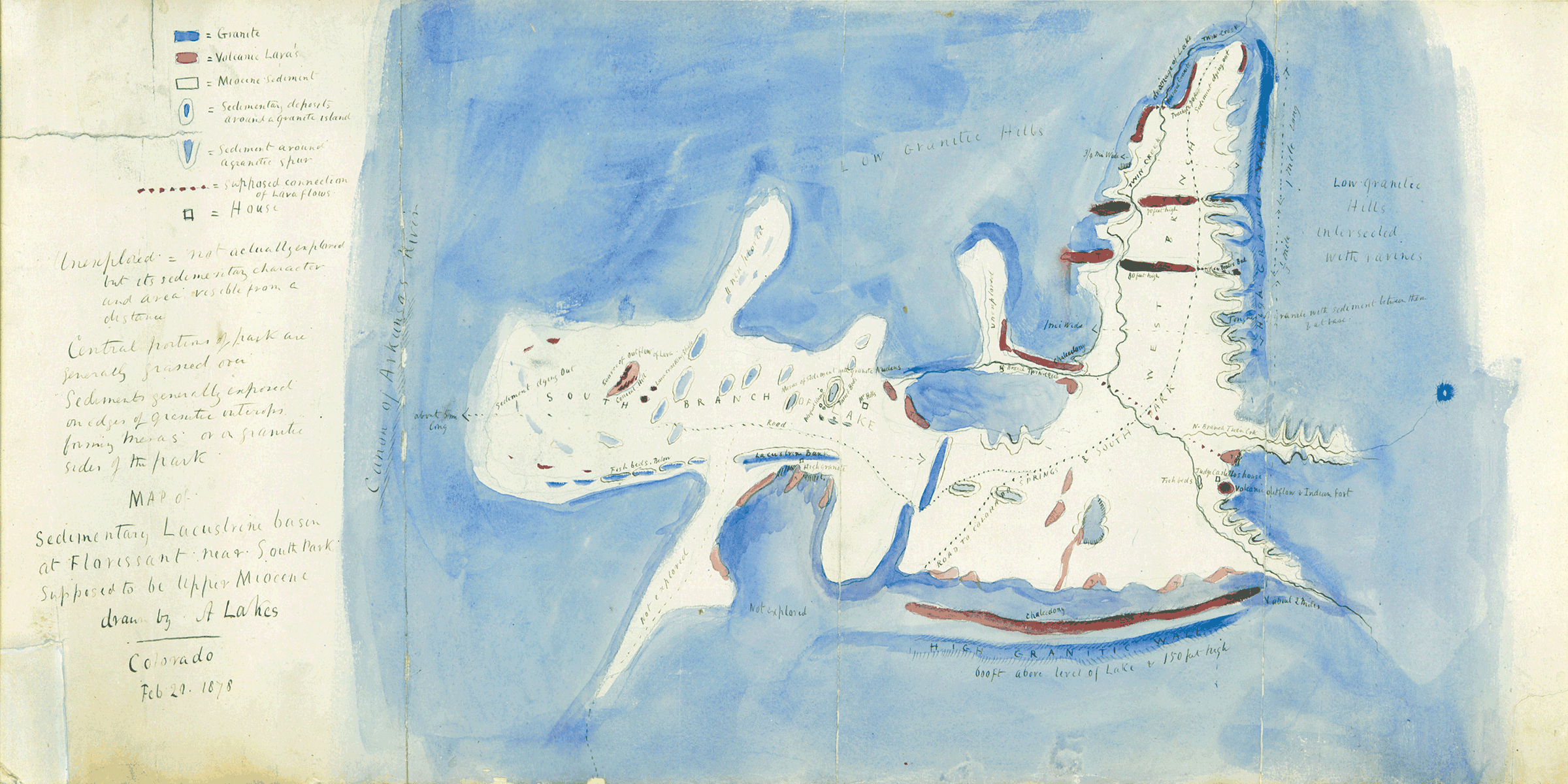
The geology of Florissant valley was first mapped by Arthur Lakes in 1877. The following year, Lakes produced a watercolor map titled “Map of sedimentary lacustrine basin at Florissant near South Park, supposed to be Upper Miocene”. Of course, thanks to scientists, we now know the age of the sedimentary deposits of the Florissant Formation is Eocene in age, not Miocene as Lakes had suggested. The watercolor map included locations of fossiliferous beds, other rock units such as granite, volcanic lavas, and sediments. In addition, Lakes also included settlements such as the houses of local residents/families Castello and Hill.
Preparation
You will need:
-
Watercolor paint (best)/marker/colored pencils
-
Paper (watercolor paper best)
-
Pencil
-
Mapping Florissant Fossil Beds video
-
Picture of Arthur Lakes’ Florissant valley watercolor map
Materials
Arthur Lakes' 1877 watercolor geologic map of the Florissant Valley.
Lesson Hook/Preview
Geologists make special geologic maps that show geologic features to help them identify rocks while in the field. Different rock units are shown with different colors and/or symbols to show where they are exposed at the surface. In order to make a geologic map, geologists have to go out into the field and search for exposed rock layers and contacts where those different rock types or units meet.
Procedure
#1: Go over the background information with the student(s).
Arthur Lakes first mapped the Florissant valley in 1877. A year later he made a watercolor map named "Map of sedimentary lacustrine basin at Florissant near South Park, supposed to be Upper Miocene". Today we know that the Florissant Formation is actually from the end of the Eocene rather than the Miocene. Lakes' watercolor map showed the locations of the fossil rich beds and other rock units including granite, volcanic lavas, and sediments. He also added landmarks such as the homes of local residents and families. This made it easier for others to orient the map and where they were according to it.
#2: Open the Mapping Florissant Fossil Beds video and play it. Follow our intern to an outlook where you can see Florissant Valley.
#3: Pause the video so you can see the view of Florissant Valley and paint your own geologic map of the valley. Remember to include a north arrow and something like a road or the Hornbeck Homestead to help orient your map. You can draw these in with your pencil.
Vocabulary
-
Geologic map: noun; a special map that shows geologic features and rock layers in an area
-
Legend: noun; an explanatory list of the symbols on a map or chart
-
Fossiliferous: adjective; rich in fossil materials
-
Sedimentary: adjective; formed by or of sediment or materials such as stones or sand
-
Lacustrine: adjective; or, relating to, formed in, or growing in lakes
Assessment Materials
ReflectionWhat was the most difficult part in creating the geologic map? Why do you think geologists today do not use watercolors to create geologic maps?
Based on your map, what can you infer about the area geologically speaking? What type(s) of environment(s) must have existed for these rock units to exist here?
Rubric/Answer Key
Watercolors are messy and tend to spread and bleed, so it is harder to make a clean and precise map.
Based on the different volcanic rocks there used to be a volcano nearby. The Florissant Formation tells us that there used to be a redwood forest and a shallow lake here.
Additional Resources
Check out our Geologic Maps activity webpage for step by step instructions with pictures!