Last updated: November 15, 2024
Thing to Do
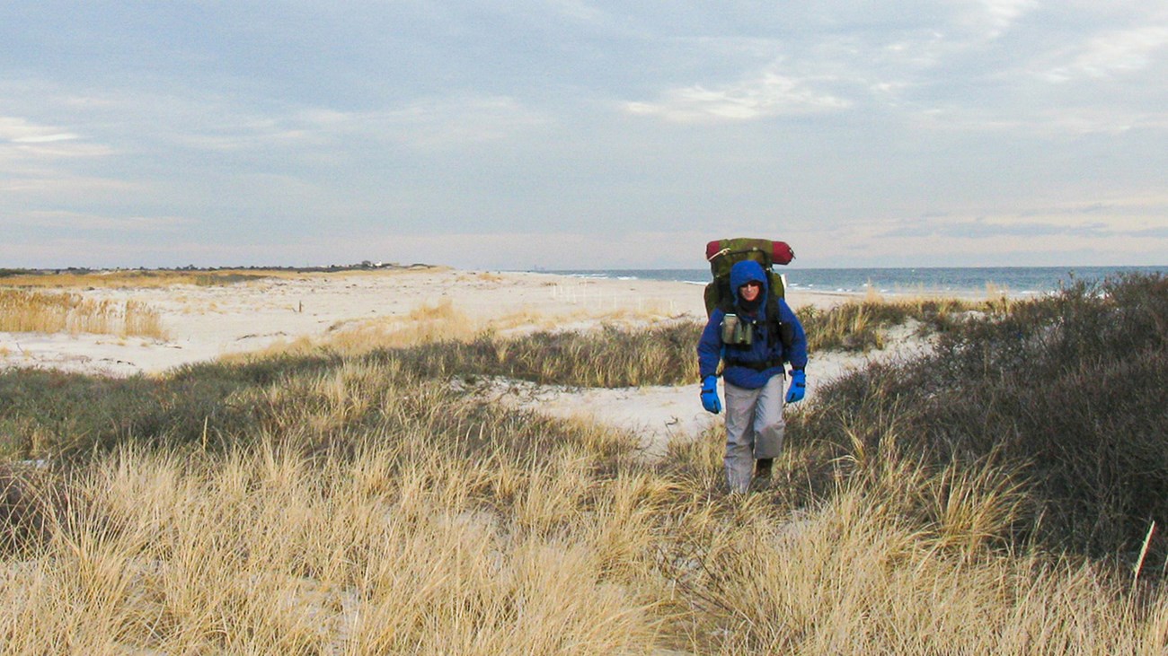
Burma Trail
NPS Photo
Download a trail map (PDF - 1.74 MB)
Burma Trail is a seven-mile-long footpath that spans the Otis Pike Fire Island High Dune Wilderness Area from Watch Hill to Smith Point.
The Burma Trail follows part of the trace of the old Burma Road, an off-road vehicle route used before the area's wilderness designation in 1980. Most of the road has disappeared under dunes or vegetation, but in some places it remains clear. Hikers may also find traces of human development, such as concrete pads used by the US Life Saving Service and Coast Guard, bricks used for summer bungalows, or the remnants of shipwrecks along the shore. While these reminders of the human past may seem to run counter to the idea of wilderness, you might think of the area as reclaimed by nature, rather than “untouched” or “pristine.”
The Burma Trail allows access to wilderness for hikers, photographers, birders, campers, anglers, hunters, and others. Whether your visit is for a short stroll, a full-day outing, or an overnight trip, visitors should take care to keep this area wild and minimize their impact on the landscape and wildlife.
Hikers typically access the trail at the Wilderness Visitor Center or Watch Hill. Those interested in hiking during cooler months from the western end can take a ferry and walk an additional mile from Davis Park (ferry service is limited between October and May – check the latest schedule).
Interested in camping overnight? Learn more about backcountry camping in the Otis Pike Wilderness.
Hike Smart
- Hike the trail in cooler months. Mosquitoes are prevalent north of the primary dune from late spring until late fall. The trail is best enjoyed during cooler seasons when adult mosquitoes are not present. Hiking on the ocean beach can be a more comfortable option in warmer months.
- Stay on paths. Protect vegetation and dunes by staying on trail or on deer paths. Walking on paths also helps avoid ticks and poison ivy.
- Trail conditions. Storms can cause flooding and overwashing of sand on the trail. Be prepared to wade flooded areas and navigate through altered sections of trail. Parts of the trail may become overgrown with brush. If the trail is impassable, walk to the ocean side through a low point in the dunes and walk the beach.
- Backcountry camping in the east or west zones requires a permit purchased on recreation.gov. Campers can select a campsite in established zones north of the primary dune year-round or on the beach between March 15 and Labor Day. Learn more about backcountry camping.
- Check the weather and tides before your hike. Storms and seasonal tides can present dangerous conditions with ocean water pushing to the dune line and causing overwashes in low-lying areas. This creates river-like washes that can sweep away tents and cause hazardous conditions if wading across. Avoid setting up camp where sandy washes are observed--these areas are especially prone to flooding.
- Bring plenty of water. No drinking water is available between the Wilderness Visitor Center and Watch Hill.
- Protect yourself from the sun. Wear a hat, cover legs and arms, and wear sunscreen. There is little shade on the trail. Learn more about sun protection.
- Avoid pests. Mosquitoes are present in warm months. Ticks are common--inspect yourself after a hike. Avoid poison ivy.
- Duck hunters may be encountered in season. Duck hunting is permitted in the wilderness area and Great South Bay during the fall and winter north of Burma Trail.
Details
Activity
Hiking
Pets Allowed
Yes
Pets are restricted within the wilderness and ocean beaches from March 15 to Labor Day.
Activity Fee
No
Entrance fees may apply, see Fees & Passes information.
Location
Fire Island National Seashore - Otis Pike Wilderness
Reservations
No
Season
Winter, Spring, Fall
The backdune wilderness trail is hiked most comfortably in cold weather, as adult mosquitoes are not present. Ticks can be present year-round, though they are not as active in the winter. Tick checks should be performed after a hike.
Hiking the ocean beach adjacent to the wilderness area can be a more comfortable option in warmer months.
Hiking the ocean beach adjacent to the wilderness area can be a more comfortable option in warmer months.
Time of Day
Any Time
Accessibility Information
This trail exists in a wilderness area and is not maintained for accessibility. Most of the trail is about 3 feet wide, with some sections overgrown with vegetation, sand-buried, or flooded after storms. The surface of the trail is fine sand and dirt. The grade of the trail is generally flat with sections that ascend and descend sand dunes as high as 20 feet. Hikers should expect varying conditions and should have a basic understanding of backcountry navigation before hiking.