Last updated: December 7, 2024
Thing to Do
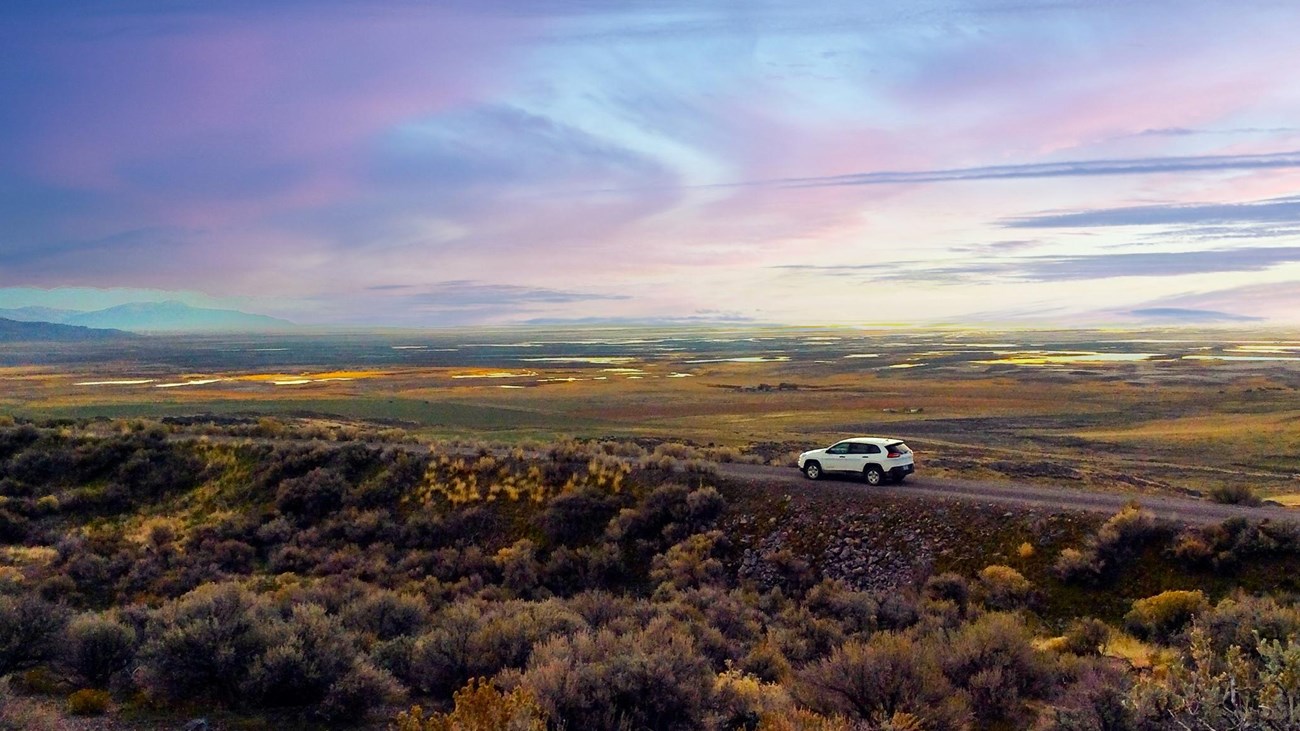
East Auto Tour
Courtesy NPS
The East Auto Tour is two miles long and follows the original Transcontinental railroad grade, allowing visitors to experience what passengers would have encountered on their travels into Promontory Station. Sweeping views of the Wasatch mountains, Chinese Arch and up close examples of railroad construction methods such as earthen fills, railbed cuts, and rock culverts can be found along the route. The tour begins 4 miles east of the Visitor Center via Golden Spike Drive. The East Tour is subject to closure during inclement weather.
*Auto Tours are not approved for RV's or vehicles pulling a trailer. The availability of the Auto Tours is subject to change without notice.
(The numbers below correspond with points of interest markers along the auto tour. Companion booklets are available for purchase in the park store, located in our Visitor Center.)
10 - An Unlikely Meeting Place
Leave your vehicle again and walk the one hundred and sixty-five yard to the long, deep cut at the end of the path. This was Union Pacific's last major rock cut before reaching Promontory Summit. On the opposite side you can see how workers neatly stacked the rocks to keep debris out of the cut.
*Auto Tours are not approved for RV's or vehicles pulling a trailer. The availability of the Auto Tours is subject to change without notice.
(The numbers below correspond with points of interest markers along the auto tour. Companion booklets are available for purchase in the park store, located in our Visitor Center.)
10 - An Unlikely Meeting Place
In the spring of 1869, with the Union Pacific already in Ogden and the Central Pacific closing in from just west of the Great Salt Lake, Congress and the two companies agreed to meet at a point equidistant between two ends of the track. Promontory Summit became the site for the Last Spike just by chance.
During 1869, both rail lines terminated here and travelers were obliged to change trains to complete their journey east or west. It was an inconvenient arrangement since there was no water for locomotives, horses, or people. An early description listed the amenities.
The town consists of a few tents, the ticket houses of both companies, their telegraph offices, hordes of grasshoppers and swarms of sand fleas.
In early 1870, as part of an agreement between the companies, the terminus was moved to Ogden. As a result, trains no longer stopped regularly at Promontory and curious passengers only glimpsed the Last Spike site as they rolled by.
11 - Union Pacific's Last Cut
Ironically, some of the most difficult work for the Union Pacific on their line from Nebraska to Utah was here in these mountains, only a few miles from the completion site. A tortuous ten miles of track, with an average climb of eighty feet per mile, was laid from the valley floor to the summit of the pass. Included in the construction were four long fills, four major trestles, five sizeable rock cuts, and numerous culverts.Leave your vehicle again and walk the one hundred and sixty-five yard to the long, deep cut at the end of the path. This was Union Pacific's last major rock cut before reaching Promontory Summit. On the opposite side you can see how workers neatly stacked the rocks to keep debris out of the cut.
12 - Trestles and Fills
Union Pacific crews began construction work in the Promontory Range much later than Central Pacific. Their belated start and the difficult job required shortcuts wherever possible.
On the right, workmen trestled across this ravine rather than completing the fill as originally planned. A culvert crew finished a lengthy stone waterway along the bottom of the ravine before the decision was made to build a trestle instead. Central Pacific builders, on the other hand, were here through the harsh winter of 1868-69. They had more time and easily completed their fill across the same ravine.
13 - Blasting
Deep rock cuts like this one required specialized labor, tools, and huge quantities of explosives. Cuts were started by two-man drilling teams called double-jackers. One worker rotated a steel, chisel-like star drill, while the other struck it with a sledgehammer. A good double-jack team could drill a thirty-inch-deep hole in an hour. Look carefully; many of these drill holes are still visible.
When drilling was completed, a powder monkey filled the holes with black powder and connected each hole with fuses. Once everyone was out of the way, the charges were ignited.
A reporter from Salt Lake City's Deseret Evening News vividly described cutting here in the Promontorys:
Sharp & Young's blasters are jarring the earth every few minutes with their glycerin and powder, lifting whole ledges of limestone rock from their long resting places, hurling them around... in every direction. Mr. T. E. Ricks showed me a boulder of three or four hundred pounds weight that was thrown over a half mile and completely buried itself in the ground within twenty yards of his cook room. I ate a hearty breakfast and left that spot sine die.
14 - Choosing a Route
The Great Salt Lake creatd a sizeable barrier to the railroad. The Union Pacific entered the valley from the east through Weber Canyon into Ogden. The choice then was to go around the lake either to the north or the south. Residents of Salt Lake City pressed the railroads for a southerly route, which would bring it right through town.
Planning engineers recognized geologic evidence that suggested the northern route. Look across the valley at the level benches on the hillsides. These are old shorelines left when the lake was deeper and larger. The railroads eventually chose the route around the north end so the line would not be endangered by rising lake waters. In view of the lake's recent fluctuations, do you think they made the wise choice?
15 - Natural Memorial
The limestone formation on your left, known as the Chinese Arch, has become a memorial to the thousands of Chinese who helped build the transcontinental railroad. Labor was scarce in California. The Central Pacific first employed Chinese experimentally in 1865. They proved themselves to be excellent workers and soon the company recruited directly from China. By 1868, over 11,000 Chinese laborers were employed on the railroad.
Many of the Chinese remained with the company after the race to Promontory ended. Travelers often noticed their tents along the transcontinental route. Apparently one such camp was here during the 1880s when the arch was given its special name.
16 - The Steepest Grade
You are now descending the steepest mile of railroad in Utah. The Pacific Railroad Act of 1862 authorized construction of and stipulated that grades were not to exceed 2.2%, or 116 feet of elevation per mile. This stretch measures 1.7% or 90 feet per mile, a hard pull for steam locomotives of the day. Yet, in the entire 1,776 miles of the transcontinental railroad, the grade seldom exceeded 1.5%.
After the line was completed, the Central Pacific stationed "helper" locomotives at the base of the grade to assist heavy trains up the hill.
17 - More to Discover
Look across the valley to the right. Can you see the two grades on the hillside? After their descent to the valley floor they run parallel to Highway 83 into Brigham City. With a sharp eye you will be able to see them on your right if you drive into town.
There is more to see at Golden Spike National Historical Park. You may wish to turn left here and drive to the Big Fill parking area a short way up the hill. A three-quarter-mile walk beyond the parking area will take you to the Big Fill and Big Trestle site, two of the most impressive structural remains in the park.
18 - Big Fill and Big Trestle Site
This leisurely walk will allow you to see many of the details of railroad construction close-up. Look for drill marks in the deep cuts. These long, straight scars from 1869 are silent testimony to the hurdle over the mountains.
You are walking on the Central Pacific grade that was maintained by the railroad from 1869-1942. Early in World War II, steel was needed for the war effort and tracks here were pulled up and scrapped. The Union Pacific grade to your right was used for less than a year after the railroad was completed. When the station was moved from Promontory to Ogden, the Central Pacific relocated the tracks to the grade they constructed, leaving the Union Pacific grade to the elements.
When building grade across the gully, a rock fill was preferred to constructing a wooden trestle. A fill took longer to build but was easier to maintain and was more durable. This "Big Fill" was built and named by the Central Pacific. However, the Union Pacific was pressed for time and chose a trestle for this site. Only thirty-two days were needed for construction but it produced a rickety structure at best. When the Central Pacific took control of the mainline between Promontory and Ogden, they moved the track to their own grade and abandoned the trestle. Most of the lumber was take for use elsewhere and within a few years only the rock fill abutments remained.
Details
Duration
30-45 Minutes
Activity
Scenic Driving
Age(s)
Visitors of all ages are encouraged to participate in the scenic driving tours as passengers. Drivers must be of legal driving age.
Pets Allowed
Yes
Activity Fee
No
Entrance fees may apply, see Fees & Passes information.
Location
Start of the East Auto tour
If you prefer to take a shorter tour, turn left as you leave the parking area at the Visitor Center and begin with stop number 10 at the railroad crossing. This abbreviated tour will take approximately 30 minutes.
Reservations
No
Accessibility Information
The road is two miles long and gravel. RV's and vehicles pulling trailers are prohibited.