Last updated: October 10, 2024
Thing to Do
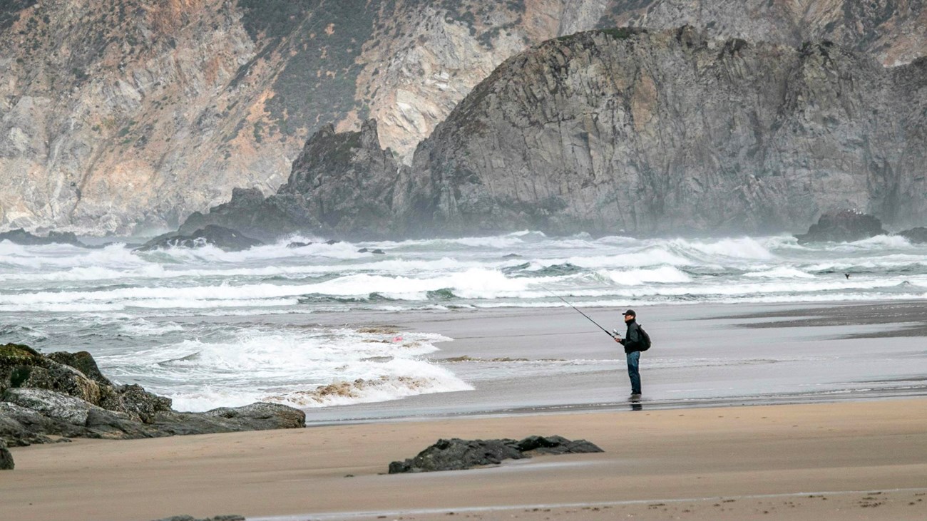
Fishing at Point Reyes
NPS / A. Kopshever
What comes to mind when you think about fishing? Patience, relaxation, challenge, and memories are a few words often associated with fishing. You will find all that and a sense of stewardship, conservation, and preservation on this page. We want you to have an enjoyable time during your visit, and for those who come after you to fish. Take some time to explore, learn what the park has to offer and learn your responsibilities before casting a line or flicking a fly into the water.
From shore or by boat, Point Reyes National Seashore allows fishing as a means of providing for public enjoyment, and customary and traditional use, and regulates fishing to ensure that it is managed in a manner that avoids unacceptable impacts to park resources.
For more information on fishing at Point Reyes, visit the Fishing at Point Reyes page.
Licenses
A valid California fishing license is required to fish in the park, and fees vary. Children under 16 years of age do not require a license. Visitors fishing within Point Reyes National Seashore must follow the fishing license requirements in accordance with the laws and regulations of the California State Fish and Wildlife regulations.
Fishing Regulations
Per the Code of Federal Regulations Title 36 Chapter I Part 2 Section 2.3, fishing shall be in accordance with the laws and regulations of the State of California except as provided in the Prohibited Practices and Regulations specific to Point Reyes sections on the park's Fishing page. Where there is a conflict between a state regulation and a federal (NPS) regulation, the state regulation is superseded by the federal regulation.
For state fishing regulations, please visit the California State Fish and Wildlife regulations website.
For more information on how NPS fishing regulations work, go to the regulations page on the NPS Fish and Fishing website's How Regulations Work page.
Where to fish
Fishing is allowed in Tomales Bay, from most park beaches, and in freshwater lakes and ponds. Anglers fish from shore or by boat. Always check the weather and marine forecasts before kayaking, canoeing, boating, etc. Visit our Your Safety While Boating page for information on preparing for and remaining safe while boating in the Point Reyes area.
To better protect endangered and/or threatened species of fish or to preserve critical habitat, fishing is prohibited in:
- Lagunitas Creek and all its tributaries including Olema and Bear Valley Creeks;
- all inland freshwater streams in the park (although fishing is allowed in freshwater lakes and ponds)
- Estero de Limantour;
- the Point Reyes Headlands Marine Conservation Area;
- certain Marine Protected Areas detailed in the "Location" collapsible panel below.
Details
Activity
Fishing
Age(s)
All ages. A valid California fishing license is required to fish in the park, and fees vary. Children under 16 years of age do not require a license.
Pets Allowed
Yes with Restrictions
Pets are welcome at a limited number of beaches, so long as they remain on a six-foot or shorter leash at all times. Please visit the park's Pets page for more information.
Pets are usually allowed on the following ocean-facing beaches throughout the year (Map - 2,414 KB PDF):
- Kehoe Beach - on the beach north of the Kehoe Beach trail
- Limantour Beach - on the beach southeast of the parking lot to the beach adjacent to Coast Campground
- Point Reyes/Great Beach - on the beach from the North Beach parking lot south to the historic Navy installation/lifeboat station located approximately 1 mile (1.6 km) south of the South Beach parking lot.
Tomales Bay
Pets are permitted on boats in Tomales Bay and on National Seashore beaches on the west side of Tomales Bay from the northern boundary of Tomales Bay State Park to Elk Fence South Beach. (Map - 2,713 KB PDF). These beaches include:
- Kilkenny Beach
- Long Cove Beach
- Fruit Tree Beach
- Marshall Beach
- No Name Beach
- Tomales Beach
- Elk Fence South Beach
Pets are not permitted:
- on beaches within the Tomales Point Elk Reserve, e.g., north of the elk fence (or anywhere else within the elk reserve).
- on Hog Island, Duck Island, or Pelican Point.
- on beaches within Tomales Bay State Park.
Please note: the only way to access the Tomales Bay beaches listed above if you are accompanied by a pet is by boat. Pets are not permitted on the Marshall Beach Trail.
Activity Fee
No
Entrance fees may apply, see Fees & Passes information.
Location
Many of Point Reyes National Seashore's beaches and freshwater lakes and ponds.
Fishing is allowed in Tomales Bay, from most park beaches, and in freshwater lakes and ponds.
To better protect endangered and/or threatened species of fish or to preserve critical habitat, fishing is prohibited in:
- Lagunitas Creek and all its tributaries including Olema and Bear Valley Creeks;
- all inland freshwater streams in the park (although fishing is allowed in freshwater lakes and ponds)
- Estero de Limantour;
- the Point Reyes Headlands Marine Conservation Area;
- certain Marine Protected Areas. Visit our Marine Life Protection Act for more details.
- Point Reyes State Marine Reserve (SMR) includes the area about 0.25 to 0.5 miles off the Point Reyes Headlands and parts of Drakes Bay.
- Permitted/Prohibited Uses: It is unlawful to injure, damage, take, or possess any living, geological, or cultural marine resource.
- CA Department of Fish and Wildlife (DFW) official maps and latitudes and longitudes
- Point Reyes State Marine Reserve (SMR) includes the area about 0.25 to 0.5 miles off the Point Reyes Headlands and parts of Drakes Bay.
- Point Reyes State Marine Conservation Area (SMCA) extends from the end of Point Reyes SMR to the three mile state line. This SMCA allows for recreational and commercial take of salmon by trolling and Dungeness crab by trap.
- Permitted/Prohibited Uses: It is unlawful to injure, damage, take, or possess any living, geological, or cultural marine resource for recreational and/or commercial purposes, with the following specified exceptions:
- The recreational take of salmon by trolling and Dungeness crab by trap is allowed.
- The commercial take of salmon with troll fishing gear and Dungeness crab by trap is allowed.
- CA Department of Fish and Wildlife (DFW) official maps and latitudes and longitudes
- Permitted/Prohibited Uses: It is unlawful to injure, damage, take, or possess any living, geological, or cultural marine resource for recreational and/or commercial purposes, with the following specified exceptions:
- Estero de Limantour SMR includes all of Limantour Estero and the southern end of Drakes Estero.
- Permitted/Prohibited Uses: Take of all living marine resources is prohibited.
- CA Department of Fish and Wildlife (DFW) official maps and latitudes and longitudes
- Drakes Estero SMCA is in Drakes Estero north of the Estero de Limantour SMR and allows for recreational clamming. The plan also states, "if at any time, it becomes feasible to create a SMR at Drakes Estero, this proposal recommends doing so."
- Permitted/Prohibited Uses: It is unlawful to injure, damage, take, or possess any living, geological, or cultural marine resource for recreational and/or commercial purposes, with the following specified exceptions:
- The recreational take of clams is allowed.
- CA Department of Fish and Wildlife (DFW) official maps and latitudes and longitudes
- Permitted/Prohibited Uses: It is unlawful to injure, damage, take, or possess any living, geological, or cultural marine resource for recreational and/or commercial purposes, with the following specified exceptions:
- Duxbury SMCA is located at the intertidal zone of Duxbury Reef and is intended to protected intertidal invertebrates and algae. This SMP allows for the recreational take of finfish take from shore and abalone.
- Permitted/Prohibited Uses: It is unlawful to injure, damage, take, or possess any living, geological, or cultural marine resource for recreational and/or commercial purposes, with the following specified exceptions:
- The recreational take of finfish from shore and abalone is allowed.
- CA Department of Fish and Wildlife (DFW) official maps and latitudes and longitudes
- Permitted/Prohibited Uses: It is unlawful to injure, damage, take, or possess any living, geological, or cultural marine resource for recreational and/or commercial purposes, with the following specified exceptions:
- Point Reyes Headlands Special Closure: 1000' special closure around Point Reyes Headlands.
- Permitted/Prohibited Uses: No person except department employees or employees of the United States Fish and Wildlife Service, National Park Service, or United States Coast Guard, in performing their official duties, shall enter this area at any time.
- CA Department of Fish and Wildlife (DFW) official maps and latitudes and longitudes
- Point Resistance Rock Special Closure: 300' special closure around Point Resistance.
- Permitted/Prohibited Uses: No person except department employees or employees of the United States Fish and Wildlife Service, National Park Service, or United States Coast Guard, in performing their official duties, or unless permission is granted by the department, shall enter this area at any time.
- CA Department of Fish and Wildlife (DFW) official maps and latitudes and longitudes
- Double Point/Stormy Stack Special Closure: 300' special closure around Double Point and Storm Stack.
- Permitted/Prohibited Uses: No person except department employees or employees of the United States Fish and Wildlife Service, National Park Service, or United States Coast Guard, in performing their official duties, or unless permission is granted by the department, shall enter this area at any time.
- CA Department of Fish and Wildlife (DFW) official maps and latitudes and longitudes
Reservations
No
Season
Year Round
Winter
The heaviest rainfall occurs in the winter months. Come prepared for rain and drizzle to possibly last for several days. In between winter rains, it is often sunny, calm, and cool.
Spring
Most spring days are windy and this area frequently experiences fresh to strong breezes. Expect cool temperatures in March. By late May and early June, temperatures can be quite pleasant, even warm.
Summer
Although there is very little rain during summer months, there is often dense fog throughout the day in July, August and September with temperatures often 20 degrees cooler than at Bear Valley.
Fall
The coastal areas of Point Reyes experience some of the clearest days in late September, October and early November. The occasional storm will start rolling through in late October, bringing clouds, wind, and rain. The strongest winds occur in November and December during occasional southerly gales.
Time of Day
Day
Point Reyes National Seashore is open for day use from 6 am to midnight. Camping and overnight parking is only permitted with a valid camping permit.
There may be certain hours of the day during which the take of certain species is prohibited. Consult the California State Fish and Wildlife regulations website for specifics.
Accessibility Information
There are no fishing locations at Point Reyes National Seashore that meet the standards for being accessible.
The Kehoe Beach Trail is a relatively flat narrow 0.7-mile-long (1.1-kilomenter-long) dirt path that leads to a sandy beach. After 0.5 miles (800 meters), the trail widens but becomes sandy and climbs up and over a smallish sand dune before arriving at the sandy beach.
The descents from the parking lots to the beach at both Point Reyes Beach North and Point Reyes Beach South are steeply sloped and involve traversing over loose sand or larger boulders.
At Limantour Beach, a flat, wide paved beach access path leads south from the accessible parking spaces for 270 feet (82 meters) to a wide footbridge with a wooden surface. Beyond the footbridge to a junction with Limantour Spit Trail, the trail is covered in sand, progressively getting deeper the closer one gets to the beach. Beyond this junction, the path climbs up and over a small sand dune before arriving at the sandy beach.
The floating dock at Miller Boat Launch on the east side of Tomales Bay is advertised as "ADA accessible," but, at lower tides, the slope of some sections of the dock may greatly exceed a 1:20 ratio. And the dock doesn't have any handrails for support, nor does it have any lift to assist someone into a waiting boat.
There are no accessible facilities at any of the beaches along Tomales Bay.