Last updated: October 10, 2024
Thing to Do
Hike Jordan Pond Loop with Island Explorer Bus
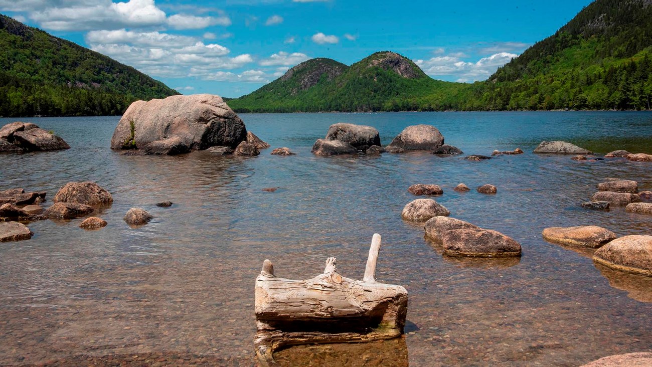
Photo by Avery Howe, Friends of Acadia
Offering visitors one of the of the iconic vistas of the Acadia, Jordan pond lies at the base three picturesque peaks: Pemetic, the Bubbles, and Penobscot. The pond is a remnant of glaciers and is the deepest of the lakes in the park at 150 feet and the second largest in the park. The calm, pristine water and the lush surroundings allow the visitor to relax on this 3.3-mile hike around the pond while soaking up some unforgettable scenery.
The Jordan Pond Loop circles one of the most picturesque ponds on the island and is considered a park crown jewel. It has been described as the “clearest lake in Maine”, and is a major tourist draw. It is at the base of several mountains that surround it, including the Bubbles on the north end, the steep rock face of Jordan Cliff to the west, and western flank of Pemetic Mountain to the east.
There are many opportunities to explore the shore of the pond and birdwatching is popular with peregrine falcons nesting in the towering rock face of Jordan Cliff during the summer, and common loons that nest on the pond below. The trail also allows for multiple opportunities to explore the shores of the pond.
Although it has no real elevation gain, the trail has three distinct walking surfaces to consider. The pond’s east side trail is mostly even with occasional exposed tree roots and rocks; the west portion requires rock hopping on and between large granite boulders, while the southwest section consists of a narrow boardwalk to protect the fragile wetland below. If looking for a hike with no obstacles, it is suggested to hike only the east side and return.
Details
Duration
1-2 Hours
For a leisurely hike, the loop can take 2 hours with various opportunities to enjoy the outstanding views.
Activity
Front-Country Hiking
Hiking: The trail starts at the pond by the Jordan Pond Dam Bridge behind the Jordan Pond House. Take in the unparalleled view of the Bubbles; these are two small mountains at the north end of the pond with impossibly clear water of the pond in the foreground. Turn to the right and take the trail along the pond’s eastern side.
The first mile has the most level surface of the loop with occasional exposed rocks and roots. Multiple points of access allow visitors to reach the shore of the pond and take in the exquisite views of the pond and the towering cliffs above.
At 1.3 miles, the Bubbles Trail and the Jordan Pond Carry Trail intersect on the right. These two trails lead to the North and South Bubbles. Go past the intersections and continue along the pond.
At 1.7 miles, the Bubble Divide Trail—which descends from the Bubbles—begins from the right. Take a moment to look across the pond to the Jordan Pond House on the opposite side of the pond, a lovely view that non-hikers never get to see.
Continuing down the path, a bridge made of hewn logs with an artistically curved arch over the center, crosses a creek. The bridge itself is photo worthy, making it a good place for a group photo.
The trail continues and soon another trail, the Deer Brook Trail, enters from the right. This trail leads visitors up a steep climb to a variety of mountain trails on the west side of the pond. Soon after, the trail crosses a rock fall of large granite boulders that have broken from the sheer Jordan Cliffs above. This will require rock hopping on and around the massive blocks of stone for the next half mile.
Care should be taken if the boulders are wet, as granite is very slippery when wet. The next half mile of the trail consists of a narrow, elevated boardwalk with multiple passing areas along the way.
The boardwalks, too, can be slippery when wet. The last stretch of the trail becomes a path and soon intersects with the Carriage Road by the Jordan Pond Dam Bridge, where the loop begins. Beginning to end, the trial has an elevation gain/loss of 28 feet.
Pets Allowed
Yes
Pets are allowed on a leash. (6-feet or shorter)
Activity Fee
No
A park pass is required for any activity in the park. The pass should be left displayed in personal vehicles. Visitors are not required to carry it with them and will not be asked to show it while on the trail or riding the bus.
Location
Jordan Pond Loop
Hiking: The Jordan Pond Loop is located directly behind the Jordan Pond House on Park Loop Road. The trail starts at the pond by the Jordan Pond Dam Bridge behind the Jordan Pond House. Take in the unparalleled view of the Bubbles; these are two small mountains at the north end of the pond with impossibly clear water of the pond in the foreground. Turn to the right and take the trail along the pond’s eastern side.
The first mile has the most level surface of the loop with occasional exposed rocks and roots. Multiple points of access allow visitors to reach the shore of the pond and take in the exquisite views of the pond and the towering cliffs above.
At 1.3 miles, the Bubbles Trail and the Jordan Pond Carry Trail intersect on the right. These two trails lead to the North and South Bubbles. Go past the intersections and continue along the pond.
At 1.7 miles, the Bubble Divide Trail—which descends from the Bubbles—begins from the right. Take a moment to look across the pond to the Jordan Pond House on the opposite side of the pond, a lovely view that non-hikers never get to see.
Continuing down the path, a bridge made of hewn logs with an artistically curved arch over the center, crosses a creek. The bridge itself is photo worthy, making it a good place for a group photo.
The trail continues and soon another trail, the Deer Brook Trail, enters from the right. This trail leads visitors up a steep climb to a variety of mountain trails on the west side of the pond. Soon after, the trail crosses a rock fall of large granite boulders that have broken from the sheer Jordan Cliffs above. This will require rock hopping on and around the massive blocks of stone for the next half mile.
Care should be taken if the boulders are wet, as granite is very slippery when wet. The next half mile of the trail consists of a narrow, elevated boardwalk with multiple passing areas along the way.
The boardwalks, too, can be slippery when wet. The last stretch of the trail becomes a path and soon intersects with the Carriage Road by the Jordan Pond Dam Bridge, where the loop begins. Beginning to end, the trial has an elevation gain/loss of 28 feet.
BUS INFORMATION: Park at the Hull’s Cove Visitor Center parking area. The bus stops are located to the right of the Pavilion at the bottom of the stairs leading to the Visitor Center.
Departure: Take the #5 Jordan Pond Bus and exit the bus at the Jordon Pond stop. The trip takes about 25 minutes. Upon disembarking, take the trail behind the Jordan Pond House to the shore of the pond by the Jordan Pond Dam Bridge where the trail begins.
Return: There is the option of taking the either the #5 Jordan Pond bus or the #4 Loop Road bus back to the visitor center parking area.
Note: Island Explorer bus operations start mid-June and continue till mid-October. Schedules are subject to change. Refer to the website for latest information. www.exploreacadia.com
Reservations
No
Season
Spring, Summer, Fall
Time of Day
Day, Dawn, Dusk
The Park and trails are open 24 hours a day, but the Island Explorer shuttle begins service to Sand beach at 9 am and ends service between 5:20 pm and 5:40 pm.
Accessibility Information
The Jordan Pond path is an unpaved trail. The first 1.3 miles is the most even section, but there are exposed roots and rocks along the way. The west side of the pond consists of large boulders to be negotiated and narrow single-file boardwalks with widened areas to make passing possible.