Last updated: February 1, 2023
Thing to Do
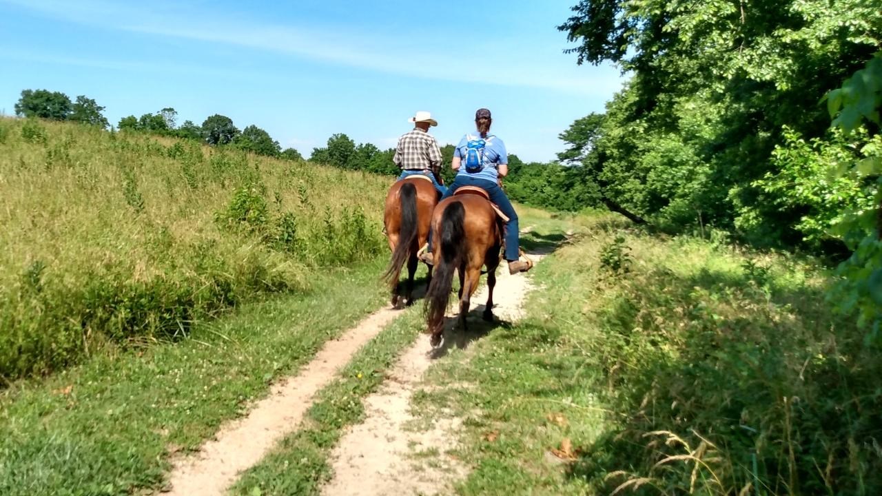
Explore with your Animal Companion
NPS Photo
Explore Wilson's Creek National Battlefield with your animal companion. You can choose from over 10 miles of trails.
Take your horse on a designated horse trail or let your dog take the lead through woodlands and trails--you will find new adventures around every corner.
B.A R. K. Ranger Policies
Bag your pet's waste
Always leash your pet
Know where your can go
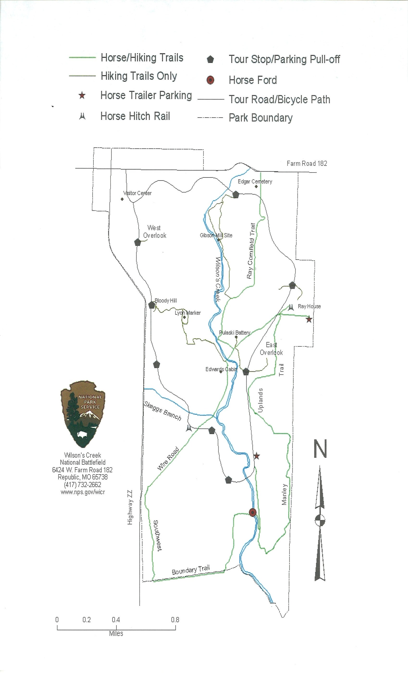
Learn more about our designated horse trails.
Take your horse on a designated horse trail or let your dog take the lead through woodlands and trails--you will find new adventures around every corner.
B.A R. K. Ranger Policies
Bag your pet's waste
Always leash your pet
Know where your can go
Learn more about our designated horse trails.
Details
Duration
2-8 Hours
The time it takes depends on your time and what you choose to do on your visit.
Activity
Self-Guided Tours - Walking
This Challenge will occur in the park when your hike, ride a bicycle along the tour road, drive to a trail and walk, ride a horse.
Once your complete your challenge you can stop in the visitor center to get your stamp for your passport book!
Once your complete your challenge you can stop in the visitor center to get your stamp for your passport book!
Age(s)
4-90
All ages are welcome!
Pets Allowed
Yes
Pets are allowed outside on a 6 foot leash and inside buildings if your pet is a service animal.
Activity Fee
No
Wilson's Creek National Battlefield does not charge an entrance fee.
Location
Wilson's Creek National Battlefield
This challenge will take place inside the park when you hike, bike, walk, drive, or ride your horse!
Self-Guided Driving or Walking Tours
- The 4.9-mile, paved tour road allows visitors to take a self-guided auto tour with eight interpretive stops at significant locations.
- The tour road includes a pedestrian lane for walkers, runner, or cyclists.
- Click here for the main park map.
- Click here for virtual tours of the battlefield.
Trails for walking, hiking, and horseback riding
- Five walking trails are accessible from the tour road and vary in length from 1/4 to 3/4 of a mile. The tour road also includes a pedestrian lane for walkers, runner, or cyclists.
- A 7-mile trail system for horseback riding and hiking is accessible from the tour road. Parking specifically for horse trailers is accessible from the tour road.
- Click here for the recreational user guide map.
Reservations
No
Season
Spring
Summer months are frequently hot and humid, with occasional showers and thunderstorms. Winter months (especially January and February) are frequently cold, with occasional ice and light snow. Spring and fall months are generally pleasant, with occasional showers.
Time of Day
Day
Tour road, battlefield, and trails are open during posted hours (changes by season). Tour Road opens at 7:00 am for walkers and bicycles only. Vehicle entrance begins at 8:00 am which requires a gate token issued inside the visitor center. The visitor center and museum hours are 8:00 am to 5:00 pm daily, seven days a week.
Accessibility Information
Tour Road
-
The length is 4.9 miles with a 150 ft elevation change.
-
The one-way tour road is 18 feet wide. The left lane (12 feet wide) is for vehicles. The right lane is for pedestrians and bicycles.
-
At each of the 8 stops, there are parking areas with designated accessible parking spaces.
-
The waysides at Stop 1, Stop 3, Stop 4, and Stop 7 (Bloody Hill) are accessible
-
The trails off the Tour Road are natural surfaces.
-
The stops are not audio described at this time.
Contact:
-
Phone: 417-732-2662
-
Email: billie_aschwege@nps.gov
Other Trail Information
-
Gibson Mill: 1 mile and 40 ft elevation change
-
Ray Cornfield: 1 mile and 80 ft elevation change (horses allowed)
-
Ray House: <0.25 mile and 30 ft elevation change
-
Ray Springhouse: <0.25 mile and 30 ft elevation change
-
East Overlook: <0.25 mile and 60 ft elevation change
-
Pulaski Battery: <0.25 mile and 50 ft elevation change
-
Manley Uplands: 2.5 miles and 170 ft elevation change (horses allowed)
-
Southwest: 1.7 miles and 140 ft elevation change (horses allowed)
-
Wire Road: 1.7 miles and 150 ft elevation change (horses allowed)
-
Bloody Hill: 0.5 mile and 60 ft elevation change
-
Bloody Hill Spur: 0.5 mile and 100 ft elevation change
- Du Bois’s Battery: 0.25 mile and <10 ft elevation change
- West Overlook: 0.25 mile and <10 ft elevation change
Learn more about accessibility at Wilson’s Creek National Battlefield.