An official website of the United States government
Here's how you know
Official websites use .gov A
.gov website belongs to an official government
organization in the United States.
Secure .gov websites use HTTPS A
lock (
) or https:// means you've safely connected to
the .gov website. Share sensitive information only on official,
secure websites.
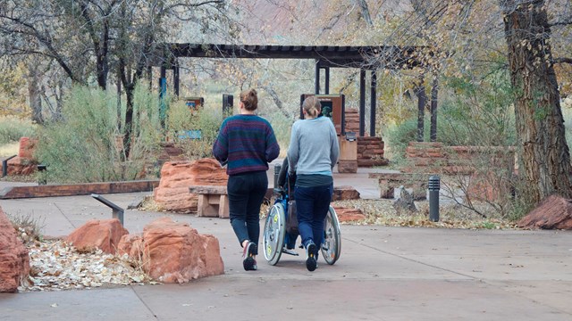
The Pa'rus Trail is the most accessible trail in the park, featuring a paved pathway, minimal elevation, and a wide tread.
NPS Photo
The tabs below contain accessibility information for some of Zion's most popular trails. For trail descriptions, images, and directions, visit our day hiking page.
Due to the natural terrain of Zion, most trails are not considered accessible. Only a few trails are wheelchair accessible with assistance, like the Pa'rus Trail or Riverside Walk. Visit each trail's page for more details. Please note that conditions may have changed since each trail was last assessed.
Zion Canyon Trails
Parus Trail Main Page Last assessed on January 13, 2025. Obstructions less than 0.5 in tall, or outside the tread area of 120 in (304.8 cm) wide by 96 in (243.8 cm), high were not reported.
Length (one way):
1.6 mi (2.5 km)
Elevation:
Gain: 151.7 ft (46.3 m)
Loss: 62.7 ft (19.12 m)
Grade:
Typical: 2.6%
Maximum: 11.4%
1.2% of the trail is at an 8.3% or higher grade.
Note: Standard accessible ramp grade is 8.3%
Cross Slope:
Typical: 2.1%
Maximum: 8.8%
4.6% of the trail has a cross slope of 6% or higher.
Tread Width:
Typical: 120 in (304.7 cm)
Minimum: 96 in (243.8 cm)
Surface:
93.6% of the trail is paved and 6.4% is hard wood decking.
Obstructions:
Bridges (5)
120 in (304.8 cm) wide
416 - 1744 in (1056.6 - 4429.8 cm) long
Post
60 in (152.4 cm) of remaining tread
Tripping Hazards (20+)
1 - 2 in (2.5 - 5 cm) tall
0 in of remaining tread
Riverside Walk Main Page Last assessed on February 24, 2025. Obstructions less than 4 in (10.2 cm) tall, or outside the tread area of 36 in (91.4 cm) wide by 96 in (243.8 cm), high were not reported.
Length (one way):
1 mi (1.6 km)
Elevation:
Gain: 154.2 ft (47.0 m)
Loss: 48.5 ft (14.78 m)
Grade:
Typical: 4.6%
Maximum: 25.9%
17.5% of the trail is at an 8.3% or higher grade.
Cross Slope:
Typical: 1.7%
Maximum: 7.6%
18% of the trail has a cross slope of 3% or higher.
Tread Width:
Typical: 77 in (194.9 cm)
Minimum: 50 in (127 cm)
Surface:
100% of the trail is concrete. Some sections may be slippery from sand.
Obstructions:
Overhanging rocks
Minimum vertical clearance: 4 ft (1.2 m)
7 ft (2.1 m) long
48 in (121.9 cm) of remaining tread
Grotto Trail Main Page Last assessed on March 5, 2025. Obstructions less than 7 in (17.8 cm) tall, or outside the tread area of 45 in (114.3 cm) wide by 96 in (243.8 cm) high, were not reported.
Length (one way):
0.5 mi (0.8 km)
Elevation:
Gain: 49.0 ft (14.92 m)
Loss: 45.5 ft (13.86 m)
Grade:
Typical: 3.5%
Maximum: 20.1%
9.7% of the trail is at an 8.3% or higher grade.
Cross Slope:
Typical: 4.1%
Maximum: 17.3%
Tread Width:
Typical: 116 in (293.7 cm)
Minimum: 15 in (38.1 cm)
Surface:
93.6% of the trail is firm soil, and 6.4% is paved.
Obstructions:
Steps
Rocks up to 21 in (53.3 cm) tall
0 in of remaining tread
Boulder in center of trail
10 ft (3 m) long
45 in (114.3 cm) of remaining tread
Lower Emerald Pools Trail Main Page Last assessed on March 20, 2025. Obstructions less than 12 in (30.5 cm) tall, or outside the tread area of 12 in (30.5 cm) wide by 96 in (243.8 cm) high, were not reported.
Length (one way, from Shuttle Stop #5):
0.6 mi (1.0 km)
Elevation:
Gain: 131.1 ft (40.0 m)
Loss: 96.4 ft (29.38 m)
Grade:
Typical: 7.1%
Maximum: 25.3%
34% of the trail is at an 8.3% or higher grade.
Cross slope:
Typical: 3.6%
Maximum: 17.1%
19% of the trail has a cross slope of 6% or higher.
Tread width:
Typical: 62 in (157.8 cm)
Minimum: 30 in (76.2 cm)
25 ft (7.6 m) of the trail is this width.
Surface:
96.2% of the trail is hard concrete with 3.8% being covered in firm soil.
Obstructions:
Bridge
Minimum tread width: 45 in (114.3 cm)
Tripping hazards
Gaps in concrete up to 2 in (5.1 cm) long
0 in remaining tread
Middle Emerald Pools Trail Main Page Last assessed on March 20, 2025. Obstructions less than 12 in (30.5 cm) tall, or outside the tread area of 12 in (30.5 cm) wide by 96 in (243.8 cm) high, were not reported.
Length (one way from Shuttle Stop #5):
0.9 mi (1.4 km)
Elevation:
Gain: 332.8 ft (101.4 m)
Loss: 152.2 ft (46.4 m)
Grade:
Typical: 10.3%
Maximum: 38.1%
44.8% of the trail is at a 10% or higher grade.
Cross slope:
Typical: 4.4%
Maximum: 20.1%
Tread width:
Typical: 57 in (144.2 cm)
Minimum: 20 in (50.8 cm)
Surface:
79.7% of the trail is firm soil, 18.7% is hard rock or concrete, and 1.6% is soft sand.
Obstructions:
Bridge
Minimum tread width: 45 in (114.3 cm)
Staircases
Steps up to 10 in (25.4 cm) tall
0 in remaining tread
Upper Emerald Pools Trail Main Page Last assessed on March 20, 2025. Obstructions less than 12 in (30.5 cm) tall, or outside the tread area of 12 in (30.5 cm) wide by 96 in (243.8 cm) high, were not reported.
Length (one way):
0.3 mi (0.4 km)
Elevation:
Gain: 75.8 ft (23.11 m)
Loss: 28.9 ft (8.81 m)
Grade:
Typical: 7.5%
Maximum: 37%
25.6% of the trail is at a 10% or higher grade.
Cross slope:
Typical: 5.2%
Maximum: 20.6%
Tread width:
Typical: 59 in (149.0 cm)
Minimum: 12 in (30.5 cm)
Surface:
45.1 % of the trail is hard rock, 35.8% is soft sand, and 19.1% is firm soil.
Obstructions:
Overhanging rock
11.3 ft (3.4 m) long
30 in (76.2 cm) of remaining tread outside of rock zone
Staircases
Steps up to 30 in (76.2 cm) tall
0 in remaining tread
Kayenta Trail Main Page Last assessed on March 3, 2025. Obstructions less than 12 in (30.5 cm), or outside the tread area of 12 in (30.5 cm) wide by 96 in (243.8 cm) high, were not reported.
Length (one way):
0.9 mi (1.4 km)
Elevation:
Gain: 204.1ft (62.2 m)
Loss: 101.9 ft (31.0 m)
Grade:
Typical: 6.7%
Maximum: 35.3%
21.5% of the trail is at an 8.3% or higher grade.
Cross Slope:
Typical: 4.5%
Maximum: 20.2%
Tread Width:
Typical: 50 in (126.1 cm)
Minimum: 15 in (38.1 cm)
Surface:
65% of the trail is firm soil, and 35% is hard concrete or rock.
Obstructions:
Overhanging rocks
Minimum vertical clearance: 5.3 ft (1.6 m)
15 in (38.1 cm) of remaining tread
Staircases
Steps up to 21 in (53.3 cm) tall
0 in of remaining tread
Watchman Trail Main Page Last assessed on January 15, 2025. Obstructions less than 4 in (10.2 cm) tall, or outside the tread area of 36 in (91.4 cm) wide by 96 in (243.8 cm) high, were not reported.
Watchman Trail to Overlook
Length (one way):
1.4 mi (2.3 km)
Elevation:
Gain: 479.4 ft (146.1 m)
Loss: 78.1 ft (23.8 m)
Grade:
Typical: 7.4%
Maximum: 39.4%
34% of the trail is at an 8.3% or higher grade.
Cross Slope:
Typical: 4.8%
Maximum: 36.8%
Tread Width:
Typical: 77 in (195.6 cm)
Minimum: 12 in (30.5 cm)
Surface:
2.2% of the trail is paved, 58.8% is hard rock, 37.4% is firm soil, and 1.6% is soft soil.
Obstructions:
Steps
Boulders up to 24 in (61 cm) tall
0 in of remaining tread
Roots 16 in (40.6 cm) long by 9 in (22.9 cm) tall
0 in of remaining tread
Overhanging rocks
20 ft (6.1 m) long
Minimum vertical clearance: 7 ft (2.1 m)
20 in (50.8 cm) of remaining tread
Watchman Loop Trail (Counterclockwise)
Length:
0.4 mi (0.7 km)
Elevation:
Gain: 80.4 ft (24.52 m)
Loss: 64.6 ft (19.68 m)
Grade:
Typical: 6.6%
Maximum: 31.5%
28.8% of the trail is at an 8.3% or higher grade.
Cross Slope:
Typical: 3.6%
Maximum: 18%
Tread Width:
Typical: 34 in (85.9 cm)
Minimum: 12 in (30.5 cm)
Surface:
73% of the trail is firm soil, and 27% is hard rock.
Obstructions:
Steps up to 12 in (30.5 cm) tall
0 in remaining tread
Sand Bench Trail Main Page Last assessed on March 19, 2025. Obstructions less than 7 in (17.8 cm) tall, or outside the tread area of 20 in (50.8 cm) wide by 96 in (243.8 cm) high, were not reported.
Length (one way):
1.5 mi (2.4 km)
Elevation:
Gain: 206.7 ft (63.0 m)
Loss: 235.2 ft (71.7 m)
Grade:
Typical: 5.5%
Maximum: 32.3%
22.7% of the trail is at an 8.3% or higher grade.
Cross slope:
Typical: 3.8%
Maximum: 23.1%
Tread width:
Typical: 60 in (153.5 cm)
Minimum: 15 in (38.1 cm)
Surface:
84.3% of the trail is firm soil, 10.3% is very soft sand, 3.9% is soft sand, and 1.5% is hard rock.
Obstructions:
Bridge
45 in (114.3 cm) wide
Steps
Rocks and logs up to 9 in (22.9 cm) tall
Staircases
Steps up to 8 in (20.3 cm) tall
Sand Bench Trail Main Page Last assessed on March 19, 2025. Obstructions less than 7 in (17.8 cm) tall, or outside the tread area of 20 in (50.8 cm) wide by 96 in (243.8 cm) high, were not reported.
Length (round-trip):
3.9 mi (6.3 km)
Elevation:
Gain: 1037.6 ft (316.2 m)
Loss: 748 ft (228.0 m)
Grade:
Typical: 8.7%
Maximum: 36%
35.6% of the trail is at a 10% or higher grade.
Cross slope:
Typical: 3.6%
Maximum: 22.8%
Tread width:
Typical: 46 in (116.9 cm)
Minimum: 6 in (15.2 cm)
Surface:
7.7% of the trail is hard rock, 19.3% is firm soil, 6.4% is soft soil, and 66.6% is very soft sand.
Obstructions:
Bridge
45 in (114.3 cm) wide
Creek crossing
Water level changes seasonally. Crossing through shallow water may be required.
Steps
Rocks up to 21 in (53.3 cm) tall
0 in remaining tread
Canyon Overlook Trail Main Page Last assessed on February 20, 2025. Obstructions less than 4 in (10.2 cm) tall, or outside the tread area of 36 in (91.4 cm) wide by 96 in (243.8 cm) high, were not reported.
Length (one way):
0.5 mi (0.8 km)
Elevation:
Gain: 154.2 ft (47.0 m)
Loss: 48.5 ft (14.78 m)
Grade:
Typical: 7.6%
Maximum: 50.4%
23.9% of the trail is at a 10% or higher grade.
Cross Slope:
Typical: 4.9%
Maximum: 50.4%
Tread Width:
Typical: 48 in (122.4 cm)
Minimum: 12 in (30.5 cm)
Surface:
73.8% of the trail is hard rock, 18.0% is firm soil, and 8.2% is soft sand.
Obstructions:
Overhanging rocks
Minimum vertical clearance: 4 ft (1.2 m)
30 in (76.2 cm) remaining tread
Staircases
Steps to 18 in (45.7 cm) tall
0 in of remaining tread
Boulder fields
Up to 12 in (30.5 cm) tall
0 in of remaining tread
West Rim Trail (to Scout Lookout) Main Page Last assessed on March 10, 2025. Obstructions less than 4 in (10.2 cm) tall, or outside the tread area of 15 in (38.1 cm) wide by 96 in (243.8 cm) high, were not reported.
Length (one way):
1.9 mi (3 km)
Elevation:
Gain: 1187 ft (361.8 m)
Loss: 63 ft (19.2 m)
Grade:
Typical: 12.9%
Maximum: 43%
67% of the trail is at an 8.3% or higher grade.
Cross slope:
Typical: 3.7%
Maximum: 18.7%
Tread width:
Typical: 63 in (159.2 cm)
Minimum: 21 in (53.3 cm)
Surface:
81.1% of the trail is hard concrete, 17.3% is concrete covered in firm soil, and 1.7% is soft sand.
Obstructions:
Overhanging rocks
Minimum vertical clearance: 7 ft (2.1 m)
173.4 ft (52.9 m) long
45 in (114.3 cm) of remaining tread
Steps
Rocks up to 6 in (15.2 cm) tall
0 in remaining tread
Kolob Canyons Trails
Timber Creek Overlook Trail Main Page Last assessed on March 31, 2025. Obstructions less than 7 in (17.8 cm) tall, or outside the tread area of 12 in (30.5 cm) wide by 96 in (243.8 cm) high, were not reported.
Length (one way):
0.6 mi (1 km)
Elevation:
Gain: 117.3 ft (35.8 m)
Loss: 103.2 ft (31.5 m)
Grade:
Typical: 6.8%
Maximum: 38%
31% of the trail is at an 8.3% or higher grade.
Cross slope:
Typical: 4%
Maximum: 27.2%
Tread width:
Typical: 54 in (137.8 cm)
Minimum: 6 in (15.2 cm)
Surface:
98.8% of the trail is firm soil and 1.2% is hard rock.
Obstructions:
Steps
Rocks and logs up to 18 in (45.7 cm) tall
0 in of remaining tread
Boulders
12-in-long (30.5 cm) area where tread is 6 in wide
30 in (76.2 cm) of remaining tread
Taylor Creek Trail Main Page Last assessed on April 10, 2025. Obstructions less than 7 in (17.8 cm) tall, or outside the tread area of 15 in (31.8 cm) wide by 96 in (243.8 cm) high, were not reported.
Length (one way):
2.6 mi (4.3 km)
Elevation:
Gain: 798.7 ft (243.4 m)
Loss: 372.8 ft (113.6 m)
Grade:
Typical: 8.4%
Maximum: 55.2%
31% of the trail is at a 10% or higher grade.
Cross slope:
Typical: 3.8%
Maximum: 25.7%
Tread width:
Typical: 45 in (113.5 cm)
Minimum: 12 in (30.5 cm)
Surface:
58.6% of the trail is firm soil, 38% is soft sand, 2.1% is very soft sand, and 1.3% is hard rock.
Obstructions:
Boulders
Steps up to 26 in (66 cm) tall
Gaps between rocks up to 7 in (17.8 cm) wide
Staircases
Steps up to 14 in (35.6 cm) tall
Creek crossings
Water level changes seasonally. Crossing through shallow water typically required.
Planning and permits for backpacking, canyoneering, and other Wilderness trips.
Last updated: August 18, 2025
Park footer
Contact Info
Mailing Address:
Zion National Park
1 Zion Park Blvd.
Springdale,
UT
84767
Phone:
435-772-3256
If you have questions, please email zion_park_information@nps.gov.
Listen to recorded information by calling anytime 24 hours a day.
Rangers answer phone calls from 10 a.m. to 5 p.m. MT, but a ranger may not answer if they are already speaking with someone else.