Last updated: April 18, 2023
Article
Volcanic Ash, Tephra Fall, and Fallout Deposits
Introduction

USGS photo courtesy of Dennis Anderson, AVO image ID 17091.
Explosive volcanic eruptions can produce great quantities of volcanic ash and tephra that are propelled high into the atmosphere in eruption columns that can even reach into the stratosphere. The largest of these eruptions, such as the caldera-forming “super eruptions” in Yellowstone, produce ash deposits that may cover thousands of square miles (kms).
Volcanic ash, pumice, and tephra ejected in violent eruptions ultimately falls back to Earth where it covers the ground like deposits of abrasive, gritty, and corrosive “snow” that never melts. These deposits may be the thinnest dustings in the case of small eruptions or when they are far away from an erupting volcano. Deposits may be many tens of feet (meters) thick near an eruptive vent or in the case of large eruptions, spread over a large area.
Volcanic ash and tephra can present geohazards that are present great distances from the erupting volcano and persist for long periods of time. Winds blowing across ash deposits can produce clouds of blowing ash long after an eruption ceases. Ash can be carried by water into streams, rivers, and lakes and choke out aquatic life. Volcanic ash also creates great hazards for human infrastructure and especially to airplanes that may fly into an ash cloud.
Western U.S.

USGS map.
Southcentral Alaska

USGS image by John Bailey.
Volcanic Ash
Volcanic ash consists of sand-sized or smaller shattered bits of rock that have diameters less than 2 mm (0.08 inches). Depending on the eruption, most volcanic ash consists of small fragments of volcanic glass that were torn apart by violently expanding bubbles of gases. Magma becomes depressurized when it approaches the Earth’s surface, allowing water, carbon dioxide, and other volatiles to exsolve and create bubbles. Volcanic ash may also consist of crystals of minerals that had been growing in the magma prior to eruption. Sometimes volcanic ash only consists of fragments of older pre-existing rock that were pulverized by eruptions.
As volcanic ash is made up of rock material, it is not the product of combustion. Volcanic ash is very abrasive due to the jagged edges of the ash particles, especially along vesicle (bubble) boundaries. It can also be mildly corrosive.
Volcanic ash can be produced in any explosive eruption, but widespread ash-fall deposits are usually only associated with Sub-Plinian and Plinian eruptions that mostly occur at composite volcanoes, and Ultra-Plinian eruptions at resurgent calderas.

USGS AVO photo by Tom Kircher.
Tephra Fall
Tephra-fall deposits are usually differentiated as to whether they consist of ash-sized particles, chunks of pumice (pumice-fall), or more generically as tephra fall or pyroclastic fall. Fallout is another generic term for ash and tephra that falls to the Earth surface from an eruption cloud.
Fallout deposits are usually well-sorted (e.g., they are made up of particles that are roughly the same size) and commonly may show layering or be bedded. Fallout deposits are usually thicker closer to the eruptive vent, and grain size is also generally larger closer to the vent.
Ancient ash-fall deposits are found throughout the geologic record, but very thin ash beds are not preserved for long periods of time.

USGS AVO photo by Lori Blank.
Fallout Deposits and Ash-Fall Tuffs
Fallout deposits are differentiated from those formed by ash-flows by the layering and well-developed degree of sorting found in ash-fall deposits.
Any rock made of consolidated or welded deposits of volcanic ash, tephra, and other volcanic debris is known as a tuff. Tuffs form either by fallout (ash-fall) or pyroclastic flows. Ash-fall deposits are frequently unconsolidated, but they can become welded if the tephra is still hot when it lands.
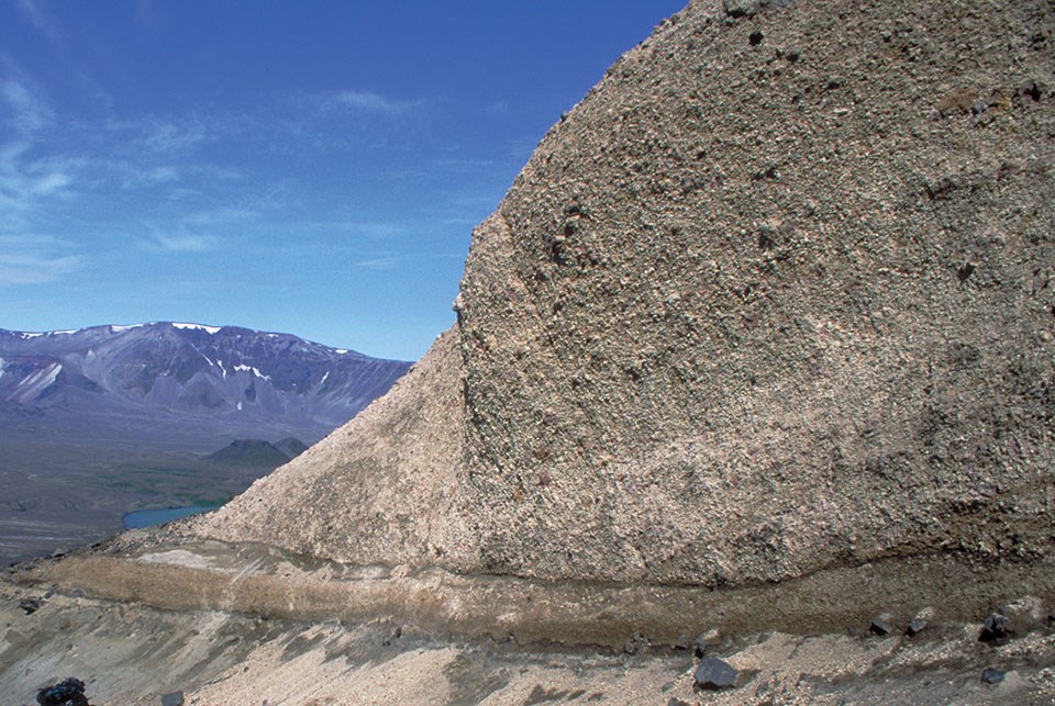
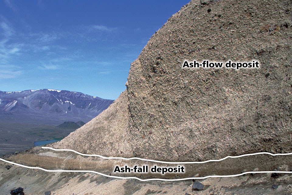
Left image
Pyroclastic-fall and pyroclastic-flow deposits from the climactic eruption of Aniakchak caldera about 3,660 years ago, which was one of the largest eruptions of the Holocene. It is common to have air-fall deposits below ash-flow tuffs.
Credit: USGS AVO photo.
Right image
One of the ways that ash-flow tuffs form is from the collapse of eruption columns to form pyroclastic flows. Layering can be seen in the ash-fall deposits, and the ash-flow deposits over them have a mix of clast size.
Credit: USGS AVO photo.
National Park Fallout Deposits
Ash-fall and other pyroclastic-fall deposits are present in 22 units of the National Park System.
These deposits range from ones that were deposited close to the volcanic center that erupted them to ones that may be hundreds or even thousands of miles from the source in the case of the largest eruptions where ash clouds spread ash over wide areas.
Volcanic ash deposits in sedimentary rock sequences such as in Agate Fossil Beds National Monument, Badlands National Park, Fossil Butte National Monument, and Petrified Forest National Park may either be from fallout or have been reworked by streams or rivers. Fallout deposits are those where ash fell from eruption clouds directly into sedimentary basins where they are deposited in situ. Reworked deposits have been transported from where the ash originally fell and deposited again, sometimes a great distance from the original fallout deposit.
Yellowstone Ash
Extremely large caldera-forming eruptions that took place on the Yellowstone Plateau during the last 2.1 million years led to ash-fall deposits throughout much of the central part of the United States. The Lava Creek ash bed covers all or part of 21 states and extends into southern Canada. Yellowstone ash has been found in Big Horn Canyon National Recreation Area in Wyoming and Montana and in the vicinity of Lake Meredith National Recreation Area in the Texas Panhandle.
-
The Huckleberry Ridge ash bed formed 2.1 million years ago. It was erupted from First Caldera (Island Park Caldera or Huckleberry Ridge Tuff Caldera), the largest of the calderas on the Yellowstone Plateau with an erupted volume of 590 cubic miles (2,450 cubic km).
-
Lava Creek ash bed formed 1.3 million years ago. It was erupted from Second Caldera (Henry’s Fork Caldera) from the smallest caldera on the Yellowstone Plateau with a erupted volume of 67 cubic miles (280 cubic km).
-
Mesa Falls ash bed formed 640,000 years ago. It was erupted from Third Caldera (Yellowstone Caldera), the most recent of the calderas on the Yellowstone Plateau with an erupted volume of 240 cubic mi (1,000 cubic km).

Modified from USGS graphic.
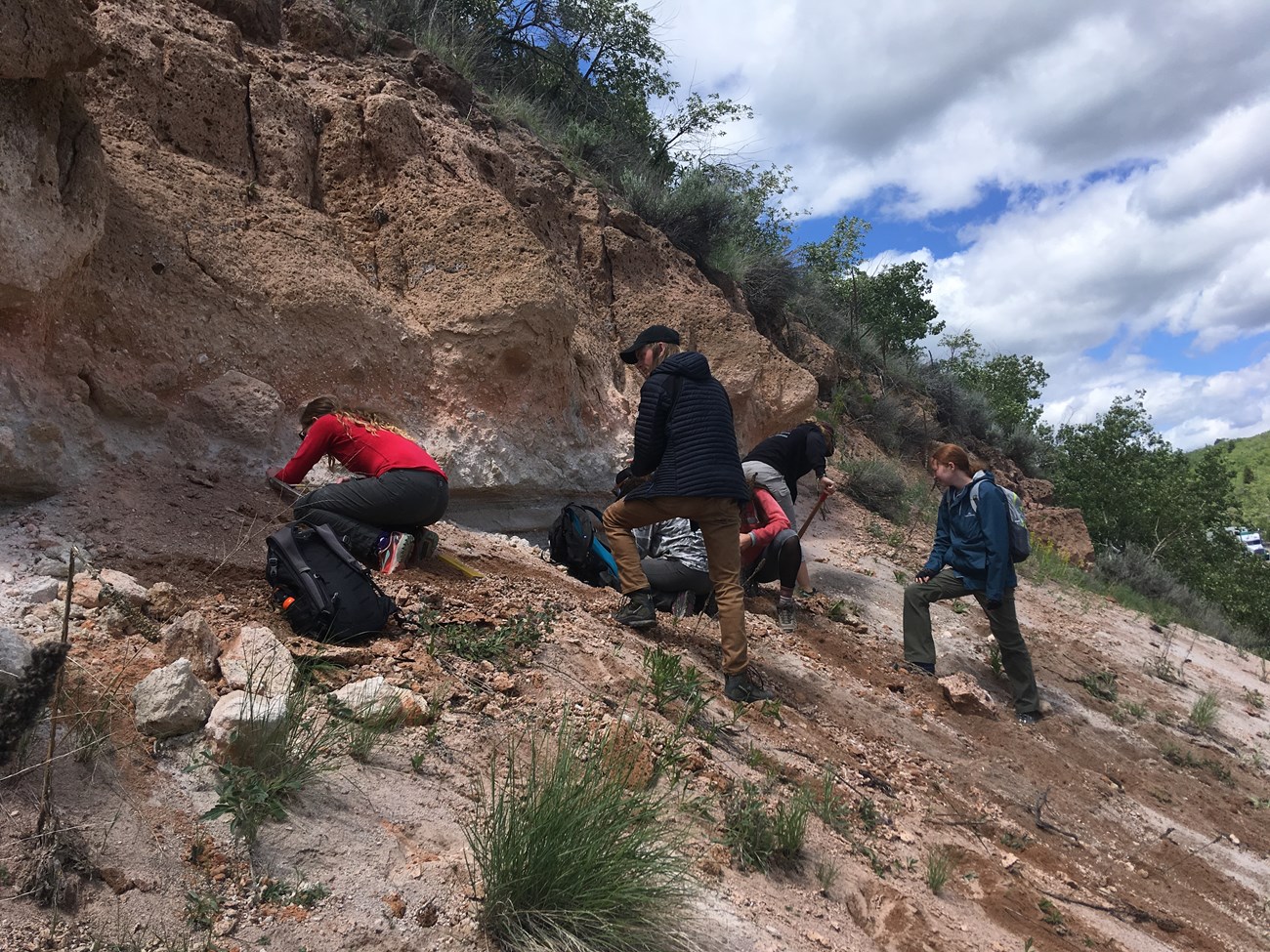
Photo by Madison Myers (Montana State University).
Learn More
Badlands National Park
Volcanic ash beds in Badlands National Park provide important age constraints for the sedimentary rocks above and below them. Geologists can date volcanic ash beds directly using techniques that utilize the decay of naturally-occurring radioactive elements in tiny mineral crystal present in ash layers (see Radiometric Age Dating). These techniques date the time that the crystals formed which equals the time of the volcanic eruption. Since ash-fall deposits form during eruptions, they also date the time of deposition of the sedimentary rock layer that they are found in. Sometimes volcanic ash beds are reworked by rivers and streams, and then deposited in sedimentary layers that are younger than the time of the volcanic eruption.

Crater Lake National Park
The climatic eruption of Mount Mazama approximately 7,700 years ago ended with a caldera-forming phase in which voluminous ash-flow tuffs were erupted. The first phase of that eruption produced a vigorous Plinian eruption column that led to widespread ash-fall and pumice-fall deposits.

Photo by John St. James on Flickr.
Katmai National Park
The Novarupta-Katmai eruption in June 1912 that emitted the Valley of Ten Thousand Smokes ignimbrite and formed the Katmai caldera was the largest of the 20th century. This eruption also produced vigorous eruption columns that formed eruption clouds that deposited ash over a large area of the northern part of North America.

Photo by By Unknown author - Alaska, Western Canada and United States Collection, Public Domain, Wikimedia Commons.

USGS map.
Lake Clark National Park
Explosive eruptions of the two active composite volcanoes (Redoubt and Iliamna) in Lake Clark National Park have left pyroclastic fall deposits in southeastern Alaska. Redoubt has had several historic eruptions with the most recent in 2009.
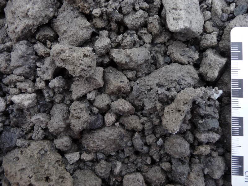
USGS AVO photo by K. F. Bull.
Yellowstone National Park
The three large caldera-forming eruptions in Yellowstone National Park led to thick deposits of tuff that contain both ash-flow and ash-fall deposits. The ash-fall deposits are generally well-sorted with discernable layering.
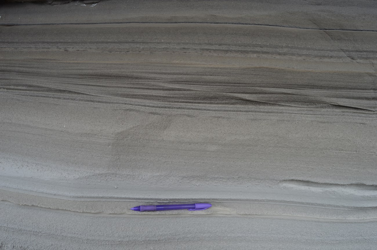
USGS photo by Cassidy Stegner (Montana State University).
National Park Containing Volcanic Ash or Fallout Deposits
-
Agate Fossil Beds National Monument (AGFO), Nebraska—[AGFO Geodiversity Atlas] [AGFO Park Home] [AGFO npshistory.com]
-
Aniakchak National Monument (ANIA), Alaska—[ANIA Geodiversity Atlas] [ANIA Park Home] [ANIA npshistory.com]
-
Badlands National Park (BADL), South Dakota—[BADL Geodiversity Atlas] [BADL Park Home] [BADL npshistory.com]
-
Bandelier National Monument (BAND), New Mexico—[BAND Geodiversity Atlas] [BAND Park Home] [BAND npshistory.com]
-
Bighorn Canyon National Recreation Area (BICA), Montana and Wyoming—[BICA Geodiversity Atlas] [BICA Park Home] [BICA npshistory.com]
-
Capulin Volcano National Monument (CAVO), New Mexico—[CAVO Geodiversity Atlas] [CAVO Park Home ] [CAVO npshistory.com]
-
Chiricahua National Monument (CHIR), Arizona—[CHIR Geodiversity Atlas] [CHIR Park Home] [CHIR npshistory.com]
-
Crater Lake National Park (CRLA), Oregon—[CRLA Geodiversity Atlas] [CRLA Park Home] [CRLA npshistory.com]
-
Craters of the Moon National Monument (CRMO), Idaho—[CRMO Geodiversity Atlas] [CRMO Park Home] [CRMO npshistory.com]
-
El Malpais National Monument (ELMA), New Mexico—[ELMA Geodiversity Atlas] [ELMA Park Home] [ELMA npshistory.com]
-
Florissant Fossil Beds National Monument (FLFO), Colorado—[FLFO Geodiversity Atlas] [FLFO Park Home] [FLFO npshistory.com]
-
Fossil Butte National Monument (FOBU), Wyoming—[FOBU Geodiversity Atlas] [FOBU Park Home] [FOBU npshistory.com]
-
Hagerman Fossil Beds National Monument (HAFO), Idaho—[HAFO Geodiversity Atlas] [HAFO Park Home] [HAFO npshistory.com]
-
John Day Fossil Beds National Monument (JODA), Oregon—[JODA Geodiversity Atlas] [JODA Park Home] [JODA npshistory.com]
-
Lake Clark National Park and Preserve (LACL), Alaska—[LACL Geodiversity Atlas] [LACL Park Home] [LACL npshistory.com]
-
Lake Meredith National Recreation Area (LAMR) (Yellowstone ash), Texas—[LAMR Geodiversity Atlas] [LAMR Park Home] [LAMR npshistory.com]
-
Mount Rainier National Park (MORA), Washington—[MORA Geodiversity Atlas] [MORA Park Home] [MORA npshistory.com]
-
Scotts Bluff National Monument (SCBL), Nebraska—[SCBL Geodiversity Atlas] [SCBL Park Home] [SCBL npshistory.com]
-
Sunset Crater Volcano National Monument (SUCR), Arizona—[SUCR Geodiversity Atlas] [SUCR Park Home] [SUCR npshistory.com]
-
Theodore Roosevelt National Park (THRO), North Dakota—[THRO Geodiversity Atlas] [THRO Park Home] [THRO npshistory.com]
-
Valles Caldera National Preserve (VALL), New Mexico—[VALL Geodiversity Atlas] [VALL Park Home] [VALL npshistory.com]
-
Yellowstone National Park (YELL), Wyoming—[YELL Geodiversity Atlas] [YELL Park Home] [YELL npshistory.com]
Related Links
Tags
- agate fossil beds national monument
- aniakchak national monument & preserve
- badlands national park
- bandelier national monument
- bighorn canyon national recreation area
- capulin volcano national monument
- chiricahua national monument
- crater lake national park
- craters of the moon national monument & preserve
- el malpais national monument
- florissant fossil beds national monument
- fossil butte national monument
- hagerman fossil beds national monument
- john day fossil beds national monument
- lake clark national park & preserve
- lake meredith national recreation area
- mount rainier national park
- scotts bluff national monument
- sunset crater volcano national monument
- theodore roosevelt national park
- valles caldera national preserve
- yellowstone national park
- volcanoes
- ash
- geology
- pyroclastic
- geohazards
