|
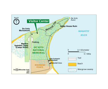
De Soto National Memorial encompasses approximately 26 acres on the south bank of the Manatee River at Bradenton, Florida. Click here to download a map of the park, with trails and primary visitor facilities. De Soto National Memorial's Street Address: Driving Directions: From I-275 exit 5, follow US-19 into Bradenton. Turn west onto State Road 64, and proceed approximately five miles to 75th Street West. Turn right (north) onto 75th Street West, and proceed two and one half mile to the park entrance and the terminus of 75th Street/ De Soto Memorial Highway. From Cortez Ave travel west to 75th St. W. turn right. Travel north on 75th St. W. approximately 4 miles to northern terminus. 75th St. W. turns into De Soto Memorial Hwy and will dead end into park. |
Last updated: March 7, 2016