Park Atlas Help
The Park Atlas is an interactive online version of common park base-maps and reference layers. The atlas includes additional geographic content, such as natural resource and cultural resource map layers, depending on availability of data for individual parks. The current version includes detailed data layers for two prototype parks: Yellowstone (YELL) and Gettysburg (GETT). Enhancements to the park atlas will be implemented over time as data and other resources become available.
Basic functionality's for the Park Atlas application include zoom in, zoom out, zoom to full extent, pan map, and identify features. The user can also use the identify function to click on a national park and view appropriate information about that park and access a direct link to the web page in a popup window (i.e. ParkNet) for that national park unit.
Future atlas options could include an intra-park planner (that includes routing inside the park), trail routing, data delivery (Zip & Ship), as well as integration with other systems, e.g. the reservation system.

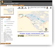
IMC Park Atlas Layout
Examples of Park Atlas Use

Displaying Relief Imagery for selected Park
- Select Relief Imagery layer from the Layer list.
- Click "Refresh Map" button
- Map will be displayed with relief imagery backdrop.

How To View Park Related Data
- Choose layer of interest from "Select Map Layer to Identify" from layer dropdown list.
- Click on "Identify" button, and click on the map.
- Park related information will be displayed in the text area.

How to Display Satellite Imagery
- Select Satellite Imagery layer from the Layer list.
- Click "Refresh Map" button.
- Map will be displayed with satellite image backdrop.
| US Department of the Interior | FOIA | Privacy Policy | Disclaimer | USA.gov |