Road Status

Road Status - Updated April 14, 2025

This report is updated when road status changes. Check Alerts at the top of this website for road updates and announcements, including daily status of the Longmire gate in winter.

  • Weather can change quickly and affect road conditions. Webcams can also provide an idea of current weather conditions.
  • Plan ahead to avoid summer congestion. The park can experience extremely high visitation with long wait times at the entrances and heavy road and parking lot congestion.
  • Some facilities may be closed even if roads are open. Check Hours of Operation for facilites at your destination and plan ahead to bring what you need, including food and water.
  • Ongoing construction projects may affect travel times or access to certain areas of the park. Check the Park Construction page for updates.

View the following road status map or road status table for updates.


All vehicles are required to carry tire chains when traveling in the park during the winter season (Nov 1 - May 1).

This requirement applies to ALL vehicles (including four-wheel drive), regardless of tire type or weather conditions. Review the Tire Chain Frequently Asked Questions for more information or learn more about Winter Recreation at Mount Rainier.


Road Status Map

For the best viewing experience, click on the "View full screen" link in the lower left corner of the map. Click on any section of road or notification symbol for more information.
 

Road Status

ROAD STATUS

Carbon River Road

CLOSED - Until further notice, there is NO access to Carbon River & Mowich Lake due to the closure of the SR165 Carbon River Fairfax Bridge outside of the park. The bridge is closed to pedestrians as well as vehicles and there is no alternate route: WSDOT News Release, 4/14/25.

SR 123 (Cayuse Pass)
South Entrance to Cayuse Pass

CLOSED for the season.

For more information, check the Washington State Dept. of Transportation (WSDOT) or call 1-800-695-ROAD (7623) toll-free statewide or 206-DOT-HIWY (368-4499) in the greater Seattle area.

Commercial vehicles prohibited at all times.

NOTE: Tunnel height limit 13' 1".

NOTE: Due to construction work in summer 2025, expect 30 min traffic delays throughout the summer. SR123 will also be fully closed north of Stevens Canyon Road to Panther Creek from September 2-September 30, 2025 (News Release, 11/20/24). For more information check the Park Construction FAQs.

SR 410 (Chinook Pass)
North Entrance to SR123/Cayuse Pass then east to Chinook Pass

CLOSED for the season.

For more information, check the Washington State Dept. of Transportation (WSDOT) or call 1-800-695-ROAD (7623) toll-free statewide or 206-DOT-HIWY (368-4499) in the greater Seattle area.

Commercial vehicles prohibited at all times.

Nisqually Entrance to Longmire

OPEN

Longmire to Paradise

OPEN
NOTE: The road can close at any time due to weather or road conditions. Check Alerts daily for status of the Paradise Road.

Mowich Lake Road

CLOSED - Until further notice, there is NO access to Carbon River & Mowich Lake due to the closure of the SR165 Carbon River Fairfax Bridge outside of the park. The bridge is closed to pedestrians as well as vehicles and there is no alternate route: WSDOT News Release, 4/14/25.

NOTE: Most of this road is gravel and some sections have rough conditions with potholes. Please drive with caution.

Paradise Valley Road
One-way scenic route leaving Paradise connecting to Stevens Canyon Road.

CLOSED for the season

NOTE: This road closure does NOT affect access to Paradise or Paradise parking lots.

Ricksecker Point Road

CLOSED in 2025 for construction.

Stevens Canyon Road

CLOSED for the season

NOTE: Tunnel height limit 12' 6".

Sunrise Road

CLOSED for the season

NOTE: Due to the steep, narrow, and winding nature of the Sunrise Road, it is recommended that RVs and vehicles with trailers longer than 25 feet LOA not travel up the Sunrise Road beyond the White River Campground intersection. Currently there are no restrictions for unmodified motor coaches of standard length.

Westside Road

CLOSED for the season

NOTE: Due to danger from rock fall, vehicles must park south of the barricade at Dry Creek. Hikers and bicyclists should travel through the area with caution and avoid lingering in the hazard zone. Visitors are also advised that Westside Road is an active geohazard zone.

White River Road to Campground

CLOSED for the season


Longmire-to-Paradise Winter Road Opening Decision Matrix

NOTE: Closed roads may be open to non-motorized vehicles like bicycles. CHECK SIGNS on closed road gates before proceeding. During snow plowing operations or when otherwise posted, park roads are closed to all use, including hiking, skiing, snowmobiles, and bicycling.


An orange, traffic sign reads "Road work ahead" sitting next to a road with an orange traffic cone.
Park Construction

Park construction includes work to improve roads and visitor areas. Learn how this will impact your travel plans through the park.
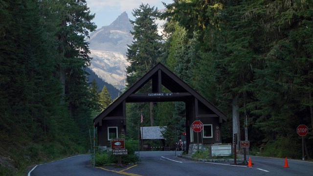
A paved road bordered by forest leads to an entrance with two booths connects by an A-frame roof.
Directions

Need directions to get to different park entrances? Also includes information on driving times to park locations.
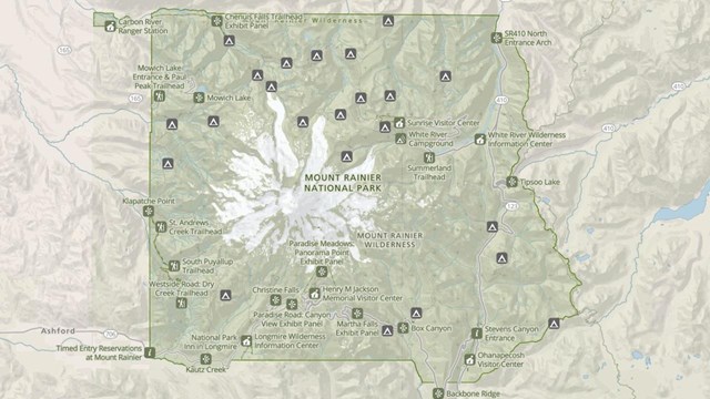
A screenshot of a map of Mount Rainier National Park shaded in green with numerous icons.
Park Maps

Maps of Mount Rainier National Park, including the Wilderness Trip Planner Map and area trail maps.

Last updated: April 14, 2025

Park footer

Contact Info

Mailing Address:

55210 238th Avenue East
Ashford, WA 98304

Phone:

360 569-2211

Contact Us