|
ZION
Mammals of Zion-Bryce and Cedar Breaks |

|
Zion-Bryce Museum Bulletin
Number 2
MAMMALS OF ZION-BRYCE AND CEDAR BREAKS
Introduction
Animal life is thought by many to be one of the major attractions in our national parks; true even in the parks and monuments of southern Utah, where large areas of bare rocks excite unusual interest in geology, but do not provide a favorable habitat for animals. It is a common thing to see visitors in Zion or Bryce turn away from the most spectacular scenery to watch a deer browsing on grape vines or a rockchuck scurrying into its burrow. Such opportunities to observe wild animals in their natural environment are more frequent in national parks than elsewhere because the Park Rangers not only enforce absolute protection of all living things, but are likewise well informed about them, and are always glad to explain them to visitors.
Answers to many of the questions about animals will be found in this bulletin, which gives brief notes on distributions, appearances, habits and haunts of the mammals so far encountered in Zion and Bryce Canyon National Parks, and Cedar Breaks and Zion National Monuments. These three areas (Zion Park and Zion Monument adjoin to form one area) are situated within a circle of 66 miles, in the high plateau region of southwestern Utah, lat. 37—38° N., with altitudes ranging from 3650 to 10,700 feet.
Zion Park and Monument constitute the largest area, 224 square miles, located on the southwest border of the Kolob Terrace or Plateau, which is here cut by an intricate system of narrow box canyons, some nearly 4000 feet deep. Bryce Park contains 55 square miles on the eastern edge of the Paunsaugunt Plateau, and is one of the "steps" in the mighty "staircase" of plateaus rising tier upon tier from northern Arizona to the largest high plateau in the United States, the Aquarius, a few miles northeast of Bryce, Utah. Cedar Breaks contains little more than 9 square miles, and is on the edge of a more westerly portion of the topmost "step", the Markagunt Plateau. A diagram of the step-like nature of the last two areas, and their altitudinal relation to Zion appears on the next page.
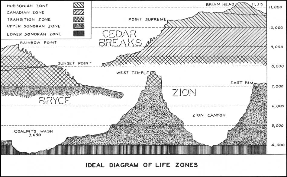
Ideal diagram of life zones
(click on image for an enlargement in a new window)
This diagram illustrates also the wide range of climatic conditions or "life zones" that exists in these areas due to their varying altitudes. Since many animals are restricted to one or two of these life zones, a brief description of the extent of the various zones is given here.
The Lower Sonoran Life Zone is limited within our areas to the three small portions of Parunuweap, Zion, and Coal Creek Canyons that are below 4000 feet altitude. These three places are the northern extremities of the hot, dry lowland. that occupy much of the Southwest. It is a semi-desert zone, largely treeless.
The Upper Sonoran Life Zone is the one most familiar to Zion visitors, since all the major canyons in Zion Park and Monument are within this zone, as is also the eastern portion of Bryce below the plateau-rim. In general, this zone occupies all the territory between 4000 and 7000 feet altitude, characterized by scrub forests of juniper and pinyon pine.
The Transition Life Zone embraces all of our plateau areas except Cedar Breaks and the highest portions of Bryce and of Zion Monument. Its approximate altitudinal range is from 7000 to 8500 feet, which makes it a zone of temperate climate, characterized by yellow pine forests. The lodge, campgrounds and much of the highway at Bryce are within this zone, as is also a small area at the bottom of Cedar Breaks.
The Canadian Life Zone, between 8500 and 10,000 feet altitude, includes the high southern half of the plateau at Bryce, and all of the colorful elopes and cliffs at Cedar Breaks. Except in such eroded sections as Cedar Breaks, it is a densely forested zone; white fir and limber pine are characteristic trees.
The Hudsonian Life Zone occurs in our areas only on the plateau at Cedar Breaks above 10,000 feet altitude. A short distance north of The Breaks, at Brian Head, 11,315, this zone extends to its upper limit at timberline. Broad meadows and stunted forests of alpine fir characterize this zone, where the winters are long and severe, and the summers cool.