|
Capitol Reef
Cultural Landscape Report |

|
ANALYSIS AND EVALUATION (continued)
VEGETATION RELATED TO LAND USE (continued)
(Orchard Summaries)
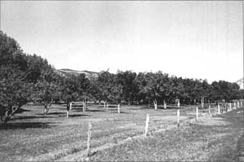
Current Name: Cook Orchard
Other Name(s): South Schoolhouse Orchard
Park Code: 0-06
Location: Located .6 miles from visitor center between south side of State Highway 24 and Sulphur Creek.
Tract: 3
Acres Cultivated:
| Orchard | 2.6 |
| Field | .5 |
| Total | 3.1 |
Number of Trees: 106
Date Recorded: 1989, March 1993
| |
| Cook Orchard | |
Historical Documentation:
Originally part of the Elijah Behunin homestead, this land was farmed by Joseph Cook (1902-1916), Andrew Adams (1916-1930), and Merin and Cora Smith (1930-1945). The Smiths plant ed the orchard. In 1940, 4.2 acres were in agriculture, with 3.4 acres in orchard, and .8 acres in fields. In 1962, 1.1 acres were lost with the construction of State Highway 24.
Historic Crops:
Cherry (81)
Apple (45)
Pear (45)
Peach (42)
Apricot (22)
Current Crops:
Cherry
Apple
Pear
Peach
Apricot
| <<< Previous | <<< Contents >>> | Next >>> |
http://www.nps.gov/care/clr/clr4d2.htm
Last Updated: 01-Apr-2003