|
Capitol Reef
Cultural Landscape Report |

|
ANALYSIS AND EVALUATION (continued)
VEGETATION RELATED TO LAND USE (continued)
(Orchard Summaries)
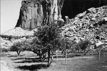
Current Name: Amasa Pierce Grove
Other Name(s): North Schoolhouse Orchard
Park Code: 0-05
Location: Approximately .8 miles from the visitor center on the north side of State Highway 24, west side of the Fruita Schoolhouse.
Tract: 3
Acres:
| Orchard | .5 |
| Field | .7 |
| Total | 1.2 |
| |
| Amasa Pierce Grove | |
Number of Trees: 47
Date Recorded: March 1993
Historical Documentation:
Originally part of the Elijah Behunin homestead, this land was owned and farmed by Joseph Cook (1902-1916), Andrew Adams (1916-1930), and Merin and Cora Smith (1930-1945). Amasa Pierce had no known association with this land. The orchard is located on the north side of State Highway 24. Thirty-three of the 47 trees in the orchard are new plantings.
Historic Crops:
Apple (38)
Current Crops:
Apple (14)
Apricot (33)
| <<< Previous | <<< Contents >>> | Next >>> |
http://www.nps.gov/care/clr/clr4d3.htm
Last Updated: 01-Apr-2003