|
Capitol Reef
Cultural Landscape Report |

|
ANALYSIS AND EVALUATION (continued)
VEGETATION RELATED TO LAND USE (continued)
(Orchard Summaries)
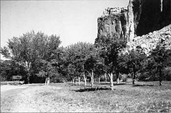
Current Name: Behunin Grove
Other Name(s): North Smith Place
Park code: 0-01
Location: Approximately .8 miles east of the visitor center, on the north side of Utah State Highway 24, east of the Fruita schoolhouse.
Tract: 7
Acres Cultivated:
| Orchard | .3 |
| Field | .3 |
| Total | .7 |
Number of Trees: 18
Date Recorded: March 1993
| |
| Behunin Grove | |
Historical Documentation:
This orchard was originally part of the Nels Johnson homestead of 160 acres. Merin and/or Cora Smith owned 28 acres of this tract beginning in 1928 until it was sold to the park service in 1961. The orchard was originally planted by Cora Smith. This small portion of the orchard was physically cut off from the larger orchard to the south by construction of the State Highway 24 in 1962.
Historic Crops:
Pear (20)
Apple (6)
Apricot (1)
Cherry (1)
Plum (1)
Current Crops:
Pear
Bartlett
Plum
(old varieties scattered along the bank)
| <<< Previous | <<< Contents >>> | Next >>> |
http://www.nps.gov/care/clr/clr4d4.htm
Last Updated: 01-Apr-2003