|
Capitol Reef
Cultural Landscape Report |

|
ANALYSIS AND EVALUATION (continued)
VEGETATION RELATED TO LAND USE (continued)
(Orchard Summaries)
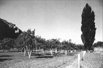
Current Name: Holt Orchard
Other Name: Middle Krueger Orchard
Park Code: 0-12
Location: Located 1.2 miles east of the visitor center, on the south side of State Highway 24.
Tract: 9
Acres Cultivated:
| Orchard | 2.4 |
| Field | 0 |
| Total | 2.4 |
Number of Trees: 129
Date recorded: 1990, March 1993
| |
| Holt Orchard | |
Historical Documentation:
This land was originally part of the Leo Holt homestead. 'Tine Oyler owned the land from 1916 until 1941. Most of the orchards were established before Oyler sold to Max Krueger in 1941. Photographic documentation indicates that this orchard once extended farther north, covering approximately 3.6 acres. In 1940, approximately 3.2 acres were orchard and .4 acres were in alfalfa. Krueger lived in California, employing local men to farm the land until 1961, when he sold it to the NPS. Approximately 1 acre of orchard was lost due to construction of State Highway 24 in 1962.
Historic Crops:
Apples (74)
Pears (66)
Cherries (27)
Apricot (10)
Current Crops:
Apple (29)
Yellow
Red Delicious
Cherry (42)
Pear (60)
Apricot (1)
| <<< Previous | <<< Contents >>> | Next >>> |
http://www.nps.gov/care/clr/clr4d7.htm
Last Updated: 01-Apr-2003