|
Capitol Reef
Cultural Landscape Report |

|
ANALYSIS AND EVALUATION (continued)
VEGETATION RELATED TO LAND USE (continued)
(Orchard Summaries)
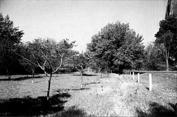
Current Name: 'Tine Oyler Place
Other Name(s): Grape Vineyard; Petroglyph Orchard
Park Code: 0-09
Location: Two parcels, located approximately 1.1 miles east of visitor center. One parcel is on the north side of State Highway 24; the other parcel is on the south side of the road.
Tract: 9
Acres Cultivated: (both parcels)
| Orchard | 1.9 | (including grapes) |
| Field | 1.2 | |
| Total | 3.1 |
Number of Trees: 32 trees (north of road)
66 trees (south of road)
Date Recorded: August 1991, March 1993 (field checked)
| |
| 'Tine Oyler Place | |
Historical Documentation:
This land was originally part of the Leo Holt homestead of 120 acres. 'Tine Oyler owned the land from 1916 until 1941 when it was sold to Max Krueger. Olyer bought 38 acres from Annie Mansfield in 1914 and an additional 27 acres from George Carrell in 1916. Documentation suggests that 6.5 acres were farmed in 1940, with approximately 2 acres in orchard and 4.5 acres in other crops (grasses). In 1962, 2.3 acres were lost to construction of State Highway 24 and .9 acres were abandoned. The grapevines received regular maintenance through the 1980s, until the deer population undermined virtually all maintenance.
Historic Crops:
Pecan (9)
Cherry (8)
Pie Cherry (4)
Apple (7)
grapevines
Apricot (8)
Current Crops:
(north side of road)
Pecan
Apple
Cherry (tart)
Peach (early)
grapevines
Plum
(south side of road)
Apple
Cherry
Nectarine
Peach
Pear
Plum
Peach (4)
Mulberry (3)
Walnut (1)
| <<< Previous | <<< Contents >>> | Next >>> |
http://www.nps.gov/care/clr/clr4d6.htm
Last Updated: 01-Apr-2003