
|
Geological Survey Bulletin 845
Guidebook of the Western United States: Part F. Southern Pacific Lines |
ITINERARY
|
|
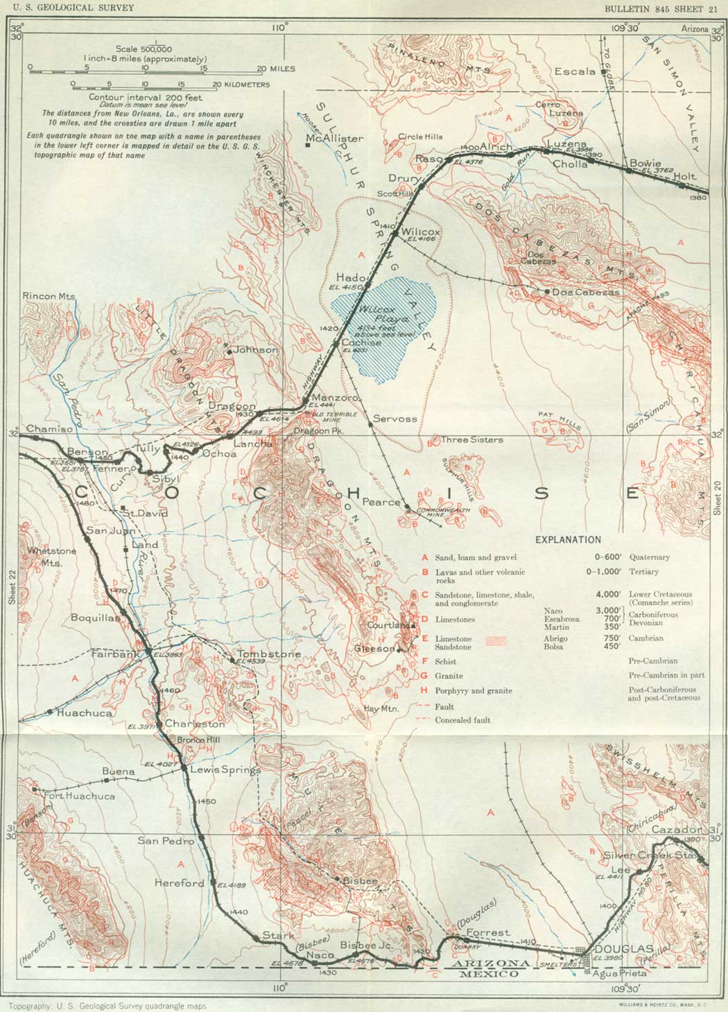
SHEET No. 21 (click in image for an enlargement in a new window) |
About 15 miles southwest of San Simon is Apache Pass, a saddle of moderate height separating the Chiricahua Mountains from the Dos Cabezas Mountains and formerly the route of all emigrant travel, including the Butterfield stage line. This region was a favorite haunt of the Apache Indians because it was not far from their stronghold in the Dragoon Mountains. A fight near this pass in 1862 between these Indians and the California Column, the troops that came from California to restore Union supremacy, led to the establishment of Fort Bowie near the pass, which was long maintained as a military outpost.
West-southwest of San Simon are the Dos Cabezas, the culminating summit of the Dos Cabezas Mountains. They consist of two rounded knobs of granite close together and strongly suggesting "two heads," which the Spanish name means. This striking landmark is visible over a wide area in all directions.15
15The Dos Cabezas Mountains are a northwesterly continuation of the Chiricahua Mountains, from which they are separated by Apache Pass. They present the same Paleozoic strata as are exposed in the Chiricahua Mountains, but the amount of uplift increases to the northwest, and the pre-Cambrian granite and schist rise gradually and constitute the summits and higher slopes of the Dos Cabezas Range. The limestone under the Martin limestone (Devonian) has the character of the Abrigo beds at Bisbee, but Ordovician fossils occur in the upper beds. Most of this limestone here has slabby bedding, weathers to a light blue-gray color, and has brown reticulating markings of a supposed seaweed on many of the bedding planes. In these peculiarities it resembles the El Paso limestone of southwestern New Mexico. It is underlain by 200 feet of slabby limestone and sandstone on 150 feet of Bolsa quartzite (Cambrian), and the Bolsa lies on the pre-Cambrian schist and granite. Volcanic rocks such as cap the Chiricahua Mountains occur only in a small area of the southwest slope. The general structure is shown in Figure 36.
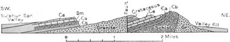
FIGURE 36.—Section of Dos Cabezas Mountains, Ariz. Ce, Escabrosa limestone; Dm, Martin limestone; €a, Abrigo limestone; €b, Bolsa sandstone; Gr, Granite
|
Bowie. Elevation 3,762-1/2 feet. Population 400.* New Orleans 1,386 miles. |
Bowie, a village in the San Simon Valley, is the junction point of the branch railroad that goes north down the valley to its mouth and thence down the valley of the Gila River, past the Coolidge Reservoir, and over a low divide to Globe (124 miles). This is the route of the Apache Trail trip to Phoenix described on page 207. The latest historical authorities appear satisfied that it was down this valley, as far as Solomonsville, that Fray Marcos de Niza and Coronado made their spectacular trips to Zuñi in 1539 and 1540. Bowie was named after Col. George W. Bowie, of the "California Column," who established Fort Bowie in Apache Pass.
High on the south side of the Dos Cabezas Mountains is the mining settlement of Mascot (formerly reached by a branch railroad from Wilcox), where considerable ore was mined some years ago. On the north slope of the range, southwest of Luzena siding (lu-say'na), there are many small placer workings from which for many years gold has been obtained, but the deposits are so irregular in location and variable in value that no attempt has been made to work them on a large scale. The gold is probably derived from quartz veins in the schist and has been set free by disintegration and washing on the mountain slopes. Northwest of Bowie and north of Luzena are the high Pinaleño Mountains, of which the culminating summit is Mount Graham, 10,720 feet above sea level (U. S. Coast and Geodetic Survey), about 30 miles distant. Mount Graham was named either for Maj. L. P. Graham, who led an expedition from Chihuahua to California in 1848, or for Lieut. Col. J. D. Graham, who acted on the United States and Mexico Boundary Survey Commission.
|
Willcox. Elevation 4,166 feet. Population 806. New Orleans 1,410 miles. |
The Pinaleño Mountains consist mainly of massive gray granite, but in their south end is a flanking mass of volcanic rocks similar to those in the Peloncillo and Chiricahua Mountains and in many other ridges in New Mexico and Arizona. Outlying exposures of these rocks also appear not far north of the railroad near Luzena siding and at intervals west. As there is considerable pine timber in the Pinaleño Mountains, they are included in the Coronado National Forest.
West from Luzena siding the railroad continues upgrade on the valley-fill deposits, which extend to and through a low, wide divide at the north end of the Dos Cabezas Mountains. This divide, known as Railroad Pass, is at Raso siding, where an elevation of 4,376 feet is attained. A short distance south of this siding are mountain slopes of schist and granite, and at the divide there is a cut in gravel. The foot of the Pinaleño Mountains lies a few miles north, and Mount Graham is discernible in the distance. To the west is a short descent to Willcox, in Sulphur Spring Valley, across which the Winchester Mountains are visible. Sulphur Spring Valley was named from a sulphur spring at the foot of a small butte 20 miles south of Willcox. Established in 1880, Wilcox was named for Gen. O. B. Willcox, at that time commander of the military department of Arizona and southern California (1878-82).
Sulphur Spring Valley is a wide, nearly level-floored basin 130 miles long, with no outlet stream, which receives the drainage of a large area of surrounding slopes and mountains. In it there has been deposited a thick accumulation of sand, gravel, and loam. Much water passes underground in this material, and about Wilcox and for some distance north there are scores of wells which obtain from this source an abundance of pure, soft water for irrigation and domestic use. The land is fertile and the irrigated areas yield various farm products, notably pink beans, and fruits. Willcox is one of the largest cattle-shipping points in Arizona and the outlet for many sheep and much wool and mohair. In the center of the basin is a large, shallow flat of about 40 square miles, of irregular shape, known as Willcox Playa. In times of rainfall this playa becomes a shallow lake, but in dry weather, which usually prevails, it presents a wide expanse of glistening salt, covered in places by ponds of saline water. Although there is little mineral matter in the run-off water from the mountains, it is all concentrated by evaporation in the central basin, of which the playa occupies the lowest part, and as this process has continued for many centuries considerable saline matter has accumulated. Sediments have been deposited at the same time, so that the basin now contains a thick succession of clay and silt and saline admixture. For a time this basin was occupied by a lake, which has been called Lake Cochise. It varied considerably in depth, but a zone of beach sands and sand dunes marks a shore line that persisted for a long period of inundation. Sand dunes of this old beach are conspicuous near Hado siding (ah'doe). Beyond this place is a broad flat of saline deposits on which, at times, considerable water is visible on each side of the embankmnent on which the railroad passes. The playa is only about 3 miles wide near the railroad but widens greatly to the east and south. Frequently there are striking mirages on this playa in which the great flat in the distance appears to be a huge lake with the buttes to the south rising as islands.
Pits dug in the valley floor near Willcox and Cochise have revealed bones of horses, elephants, camels, and bisons of early Pleistocene age. These animals were probably mired in the soft mud at the edge of the prehistoric lake.
The desert valleys of San Simon and Sulphur Spring were inhabited by Indians of the agricultural class long before the advent of the Apaches. They had small settlements on the slopes near the foot of the mountains, mostly at places where the ground was occasionally flooded by summer downpours. Most homesteaders who have tried to live in such places have failed, but the Indians had the advantage of special drought-resisting varieties of corn, beans, and squash, which matured quickly when they had a little water, and their ability to piece out the ration with mesquite beans, sacaton seed, and animal food. Possibly there were many other plants that yielded food for them. Water supply was a serious problem, for in many places the water had to be brought from a great distance. Many potsherds indicate that they had plenty of vessels for the storage of food and water.
|
Cochise. Elevation 4,231 feet. Population 100.* New Orleans 1,420 miles. |
Cochise is a small village sustained mainly by ranches in the adjoining valley, and it is the junction point of the Arizona Eastern Railroad, which goes south through Sulphur Spring Valley to the mining settlements of Pearce (15 miles), Courtland, and Gleeson and the city of Douglas. (See p. 173.) At Pearce is the Commonwealth mine, which has been producing gold and other ore for the last 35 years. The production to 1922 is stated by the present owners to have been $20,000,000.
Northwest of Cochise is a prominent butte consisting mainly of limestone of Carboniferous age, on the southern extension of the axis of the Winchester Mountains.
The old Butterfield Overland Mail, having come through Apache Pass and crossed Sulphur Spring Valley some distance south of Willcox, passed near Cochise and through Dragoon Pass to the old stage station at Croton Spring, in the San Pedro Valley. Near Cochise the railroad has a moderate upgrade to reach Dragoon Pass, the gap between the Dragoon and Little Dragoon Mountains. In the Dragoon Mountains, which lie south of the railroad, is the celebrated canyon known as Cochise's Stronghold, where the wily Apache band under the leadership of Cochise took refuge when pursued. This handsome canyon, eroded out of red granite, has so narrow a mouth that it was easily defended and never taken. Gen. O. O. Howard was secretly conducted here by agents of Cochise for the conference which led to a treaty in 1872. (See p. 147.) The remains of Cochise are buried near the mouth of the canyon, but no white man has ever known the precise location. The stronghold, now often used as a picnic ground, can be easily reached by road from Cochise.
A short distance south of Manzoro siding is the old Golden Rule mine, formerly a producer of silver ore in moderate amount, from veins at or near the contact of an igneous intrusive mass (monzonite) with limestone of Abrigo to Martin age at the north end of the Dragoon Mountains. These mountains extend south from Dragoon Pass to and beyond the mining settlements of Courtland and Gleeson and contain many small mines and prospects. The general structure of the northern and medial portions of this range is shown in Figure 37.16
16The Dragoon Mountains consist largely of post-Cretaceous granite, which cuts across the Pinal schist (Archean), Bolsa quartzite (Cambrian), Abrigo limestone (Cambrian), Martin limestone (Devonian), limestone of Carboniferous age, and sandstone and shale of Lower Cretaceous age. Small areas of Tertiary volcanic rocks occur among the ridges and on the flanks of the range. The strata are considerably hardened and mineralized by the heat of the igneous intrusions, and many large detached masses of the limestone are included in the granite. The eastward-dipping limestone succession in the north end of the range, with a thickness in excess of 2,000 feet, is mainly Naco limestone (Permian and Pennsylvanian). Abrigo limestone and the underlying Bolsa quartzite on Pinal schist are exposed in slopes 3 miles southeast of Dragoon station, with the relations shown in the upper section in Figure 37.
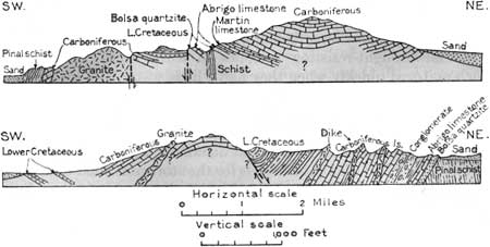
FIGURE 37.—Sections across the Dragoon Mountains, Ariz. Upper section, 3 to 6 miles southwest of the railroad; lower, 12 miles southwest of the railroad
|
Dragoon. Elevation 4,614 feet. Population 83.* New Orleans 1,430 miles. |
Some of the limestone on the west slope of the central ridge has been altered to marble by igneous intrusions, and this rock has been quarried in small amount in the slopes 3 miles southeast of Dragoon. In the higher part of the limestone succession in the north end of the Dragoon Mountains is a member of red sandstone and much coarse limestone conglomerate containing boulders of limestone and sandstone.
North of Dragoon are the high hills and ridges of the Little Dragoon Mountains, in which is situated the small mining settlement of Johnson, a copper producer for 45 years. The southern part of this range has a rough surface of knobs of granite, mostly of very coarse grain, possibly of pre-Cambrian age, although it resembles the younger intrusive granite of the Dragoon Mountains. This picturesque granite area is traversed by the highway northwest of Dragoon, where it presents an extraordinary variety of remarkable erosion forms, notably rounded masses. The rock contains large crystals of feldspar, which weather out conspicuously, and also veins of tungsten ore (wolframite and scheelite), which were mined during the World War.17 Pre-Cambrian schist is also exposed, in places overlain by Bolsa quartzite, Abrigo and Martin formations, and limestones of Carboniferous age that constitute the crest of the high ridge just west of the mining camp and also a ridge on the east side of the valley, east of Johnson. The general features in this vicinity are shown in Figure 38. The Abrigo limestone consists mostly of slabby beds and includes considerable sandy shale. At the top is a sandy member, as in the Bisbee region. An outlier of this formation caps the ridge which is skirted by the railroad 4 miles southwest of Dragoon.
17Tungsten is used mostly for the filament in electric lights and for hardening steel, especially tool steel. A large proportion of the ore now used comes from China and Burma and only one-seventh from the United States. Tungsten ore also occurs in veins in granite on the east slope of the Whetstone Mountains southwest of Benson.
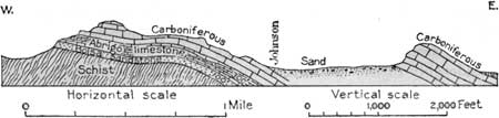
FIGURE 38.—Sketch section through the Johnson mining district, north of Dragoon station, Ariz.
From Dragoon west there is a steep down grade into the deep valley of the San Pedro River (pay'dro). This depression is very different in character from the broad, high basin of Sulphur Spring Valley—a difference due to the presence of a vigorous stream which has cut a deep, wide trench into the thick body of old stream deposits that originally occupied the valley. The San Pedro River rises in Mexico and has many affluents from the Mule, Huachuca (wa-choo'ca), Whetstone, and other mountains. Ordinarily its flow is not large, but in times of heavy rainfall there are freshets which erode the soft valley deposits and carry a large volume of detritus to the Gila River. The railroad in its descent to Benson requires many long loops to diminish the grade, and there are numerous deep cuts through the materials of the valley fill. On this grade near and beyond Ochoa siding there are fine views of the Rincon Mountains (rn-cone') to the northwest and the Whetstone Mountains to the west. The Huachuca Mountains lie far to the south; to the southeast, in the Dragoon Mountains, the impregnable western wall of Cochise's Stronghold can be seen. The granite cliffs of Cochise's Stronghold border a deep valley extending far into the Dragoon Mountains. Here the Apache Indians had a most useful hiding place, easily defended against every approach. Geroninmo fled here after his depredations and murders in Sulphur Spring Valley.
The valley-fill materials revealed in cuts, badlands, and deeply gullied slopes are mostly fine pale reddish-brown sand and loam with a few beds of coarser materials. The brownish loam predominates, with nodular layers and beds of harder sandstone projecting from it. The lower beds well exposed east of Benson are reddish clay. This succession is about 900 feet thick in the valley slopes, and several hundred feet additional is known to underlie the valley floor at Benson, although above and below that place some of the underlying granite and schist are bared near the river. The sands and clays are deposits of former streams and lakes, which occupied the valley for a long time. They lie nearly horizontal near the center of the valley and grade laterally into coarse deposits (Gila conglomerate) consisting of detritus from the adjoining mountain slopes and for the most part considerably tilted. In the clays have been found numerous remains of animals such as horses, elephants, mastodons, camels, deer, llamas, carnivores, various rodents, several reptiles, the tortoise Glyptotherium, and several species of birds which have been described by J. W. Gidley. Many are new species, and some are South American types. They are regarded as of late Pliocene age and indicate a warm, moist climate, probably subtropical. This faunal assemblage is very different from the present one and has been extinct for many thousands of years.
In the fine-grained deposits in the southern part of the valley are deposits of gypsum and thick bodies of diatomaceous earth consisting largely of diatoms, minute siliceous skeletons, mixed with volcanic ash.
The San Pedro River, which is crossed a short distance east of Benson, flows into the Gila River near Winkleman, nearly 100 miles to the northwest. It is a small stream when not in freshet but furnishes water for irrigation at several places, notably the old Mormon settlement of St. David, a few miles above Benson, established in 1878. Here also was the first artesian district in Arizona; the water is obtained from wells of moderate depth in the valley fill.
|
Benson. Elevation 3,581 feet. Population 925. New Orleans 1,452 miles. |
Benson is a small commercial center and junction point for a branch railroad up the valley to connect at Fairbank with branches to Tombstone and Patagonia. The Southern Pacific south line (by way of Douglas) is on the bench 3 miles west of Benson. In the San Pedro Valley are many ruins of dwellings and pottery and implements of aborigines who long antedated the advent of the Spanish explorers from Mexico. According to Sauer and Brand18 some of the settlements were of considerable extent.
18California Univ. Pubs. in Geography, vol. 3, No. 7, 1930.
The San Pedro River was the Rio Nexpa of the era when De Niza and Coronado made their expedition from Mexico to the Indian pueblo of Zuñi in quest of the somewhat legendary "Seven Cities of Cibola." It seems probable that their route led from Mexico down the San Pedro Valley as far as the site of Benson, thence eastward over Dragoon Pass and Railroad Pass to the San Simon Valley, which it followed northward to its junction with the Gila River. A hundred and fifty years later Padre Kino made an exploration with Lieutenant Mange and Captain Bernal along the San Pedro from Quibure northward along the base of the Rincon Mountains to its junction with the Gila and thence to Casa Grande and beyond. The valley was fertile and irrigated, and the Indians were industrious, raising maize, frijoles, calabashes, and cotton. There were 14 villages and 2,000 Indians, all very friendly to the friar. This line of travel from Benson north was followed by the road from El Paso to Yuma for which Congress appropriated $200,000 in 1857; Bancroft gives it as the route of the Butterfield stages, but Hafen includes Tucson in their itinerary. The road previously opened by Colonel Cooke and the Mormon Battalion left the San Pedro Valley at Benson, turning west to Tucson, the course now followed by the railroad. It leads through the broad divide between the Whetstone19 and Rincon Mountains at Mescal. On this rather steep climb there are many cuts through the valley fill and extensive badland slopes, and as the top of the grade is approached there are excellent views of the Rincon Mountains to the north and the Whetstone Mountains to the southwest. The Rincon Mountains consist of pre-Cambrian schist with massive platy structure that gives it the appearance of limestone to some lights. Rincon Peak, a high summit in the southern part of the range, is 8,465 feet above sea level.
19The Whetstone Mountains consist of an uplifted block of pre-Cambrian granite overlain by Paleozoic limestones and Cretaceous rocks, but as in most mountains of this character rising out of alluvial valleys, the structural relations at the sides and ends are not revealed. Granite constitutes the foot hills and peaks on the northeast end of the range except in a small skirting ridge of Lower Cretaceous (Comanche) sandstone and shale lying about 5 miles south of the railroad. A small area of Pinal schist appears on the east slope, faulted against Carboniferous limestone, and a thick mass of Cretaceous strata constitutes the southern third of the range, which is not visible from the railroad. Figure 39 shows the principal features in the northwestern part of the range. The succession, which is typical for southern Arizona, has basal quartzite (Bolsa) of Upper Cambrian age, overlain by Abrigo slabby limestone (Cambrian) which closely resembles the El Paso and Longfellow limestones. The Abrigo weathers to a light gray-blue color with brown reticulating stains on the slabs, probably due to a seaweed of early Paleozoic time. In the lower part are many layers of sandstone and sandy shale. The Martin limestone, next above, contains numerous fossils of Devonian age, some of them finely preserved, and the overlying limestones, which are 1,000 feet or more thick in the center of the mountain, include representatives of the Escabrosa and Naco carrying many fossils of Carboniferous age. The high southern summit, known as Granite Peak, appears to be a mass of intrusive porphyry cutting Cretaceous strata.
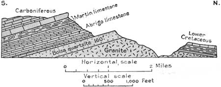
FIGURE 39.—Sketch section across the northwest end of the Whetstone Mountains, Ariz.
The Whetstone Mountains are in full view to the south from points near Mescal. The higher parts of the Rincon, Whetstone, and other mountains to the north and south are included in the Coronado National Forest so that their pine timber may be conserved.
| <<< Previous | <<< Contents >>> | Next >>> |
bul/845/sec21.htm
Last Updated: 16-Apr-2007