
|
Geological Survey Bulletin 845
Guidebook of the Western United States: Part F. Southern Pacific Lines |
ITINERARY
|
|
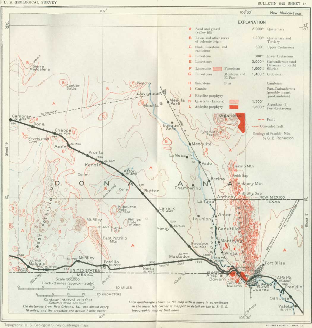
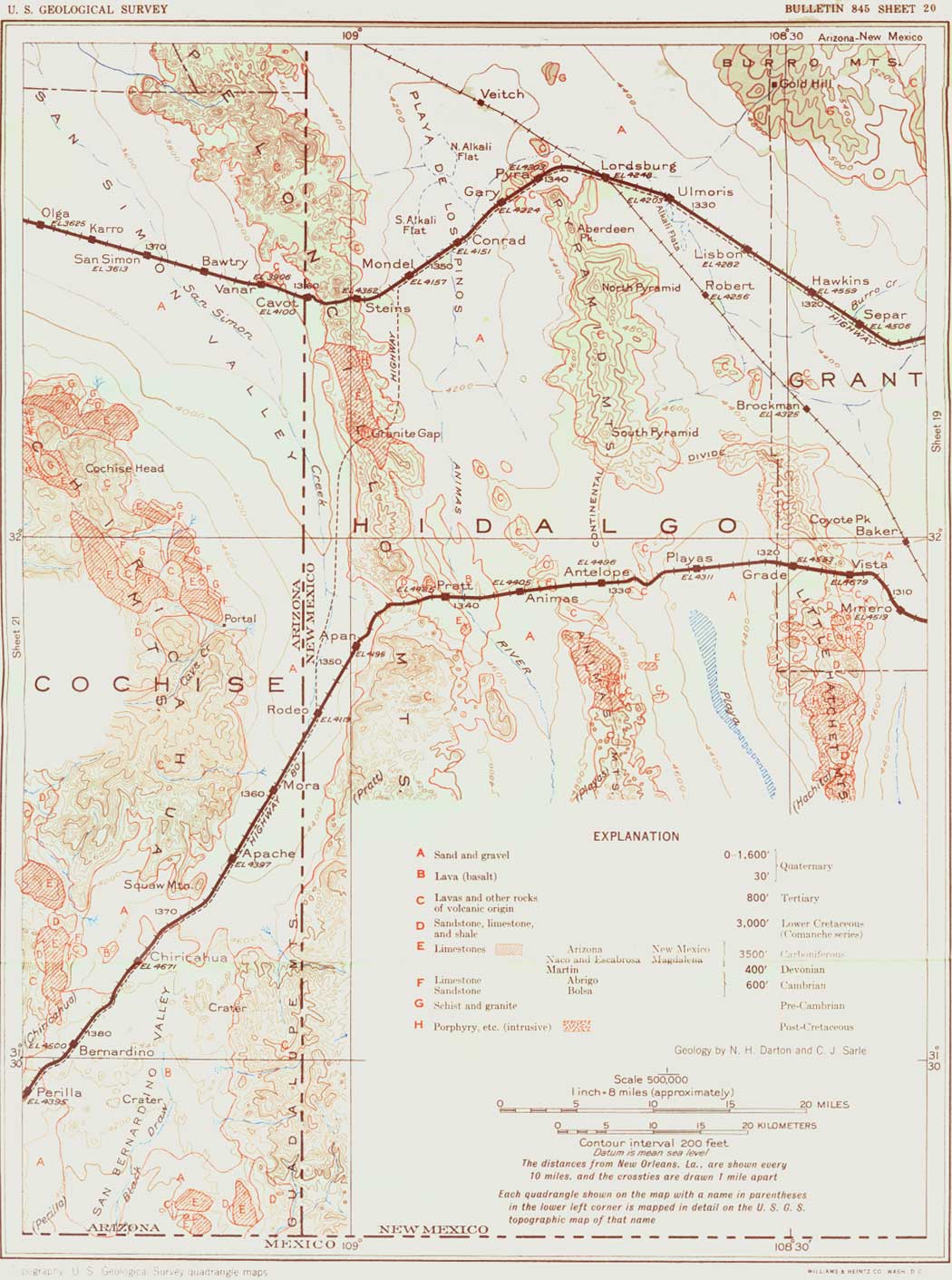
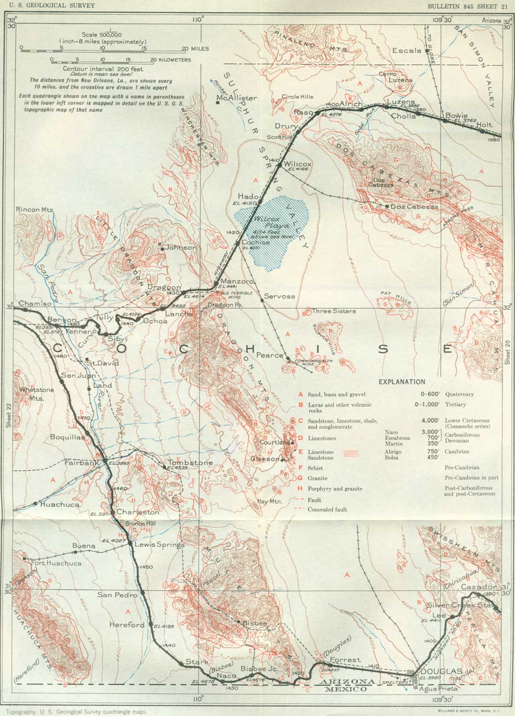
SHEET No. 18 (click in image for an enlargement in a new window) |
SOUTH LINE FROM EL PASO, TEX., TO MESCAL, ARIZ.
|
Bowen. Elevation 3,845 feet. Population 20.* New Orleans 1,193 miles. |
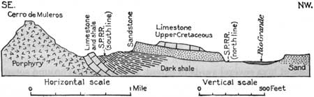
Several trains go to Tucson (see sheet 18, opposite p. 136) over the former El Paso & Southwestern Railroad, which has a more southerly route than the original Southern Pacific line by way of Deming and Lordsburg and joins the north line at Mescal, 40 miles east of Tucson. It parallels the north line for the first few miles out of El Paso, crossing the Rio Grande in the western part of the city, into the southern part of New Mexico, skirting the north side of the Cerro de Muleros (moo-lay'ros); it diverges from the north line beyond Anapra siding. (See p. 132.) Just west of the Rio Grande it passes through an area of Cretaceous strata adjoining the intrusive mass of the Cerro de Muleros, which makes the south or Mexican side of the "pass" from which El Paso is named. The strata exposed are mostly dark shale of upper Washita age in which there are long cuts, beginning a few rods beyond the west end of the bridge and extending west to and beyond Bowen, a siding at the west end of a tunnel through the shale. Below the shale are limestones of Washita and Fredericksburg age (Comanche series), the latter extensively exposed in the cement quarries a short distance north of the river bridge. (See also p. 131.) (See fig. 40.) In the upper part of the dark shale are sandy beds containing "Nodosaria" and other forms indicating Del Rio age. It is overlain by a hard sandstone probably basal Upper Cretaceous (Eagle Ford), which is conspicuous on the ridge just west of the railroad near the tunnel and crosses the railroad half a mile beyond Bowen. This sandstone is overlain by white massive limestone with many large Exogyras of Upper Cretaceous age.
|
| FIGURE 40.—Section through Bowen siding, New Mexico |
Not far beyond this place the tracks approach those of the north line, which they closely parallel to Anapra siding. Here begins the long climb to the top of the high terrace plain that borders the Rio Grande Valley and extends far westward across southwestern New Mexico. (See p. 133.) On the ascent there are fine views to the north up the Rio Grande Valley, to the east to the long west slope of the Franklin Mountains with its succession of westward-dipping strata, and to the south to high ridges in Mexico. On this upgrade there are many cuts which afford excellent exposures of the sand and gravel making up the desert plain, the top of which is reached near Mastodon siding, so named because the remains of a mastodon were excavated in the slope on the northeast. This great elephant was formerly abundant over a large part of the present United States, and his remains, as also those of the mammoth, a somewhat similar animal, are found at many places.
From Mastodon west for 17 miles there is a tangent to the foot of the Potrillo (po-tree'yo) grade where there is a rise to a slightly higher bench on the general plateau. To the north are the steep-sided East Potrillo Mountains, which consist of limestone of Comanche (Lower Cretaceous) age.20
20This limestone contains Caprina occidentalis, Trigonia sp., and Ataeonella dolium, a Fredericksburg fauna determined by T. W. Stanton.
|
Mount Riley. Elevation 4,109 feet. Population 40.* New Orleans 1,226 miles. |
From Potrillo siding west there is a down grade to Mount Riley siding, which lies south of Mount Riley. This very prominent volcanic mass, just west of the north end of the East Potrillo Mountains, was apparently a vent from which lavas were ejected in Tertiary time. To the west are broad recent lava fields of the West Potrillo Mountains, with many craters and cinder cones, some of large size. Lava flows from these vents extend in various directions, some of them being traversed by the railroad from a point 2 miles west of Mount Riley siding to their western margin, about 15 miles west of that place. Several large fresh-looking cinder cones plainly visible not far north of the railroad. West of the lava fields there are knobs of igneous rocks on both sides of the track, but they are mostly of the older period of eruption.
At intervals during Tertiary and Quaternary time there was great volcanic activity in many parts of the West, and in southwestern New Mexico large areas were covered by lavas in both periods. At numerous vents the outflow of lava was followed by an outburst of cinders and ash, which were thrown into the air and, settling back about the vent, formed a cone, generally having a central crater. The building of these cinder cones therefore usually marked the last stage of activity of the volcano, but in some places a later gush of lava issued from the side or base of the cone. The lava contained a vast volume of steam, for much of it is highly porous, or vesicular, owing to the expansion of the steam in the lava as it spread over the surface. The cinder consists of lava filled with small steam holes, so that most of it is completely porous or "pumiceous." In the cinder of the cones are usually embedded masses of compact lava, probably thrown out as bombs. These vary in form from balls to elongated and irregular shapes, mostly with smooth surfaces, such as might be expected in molten material ejected from a vent. In places there are flattened masses of lava several yards in extent, in part twisted around some of the cinders in which they are inclosed.
|
|
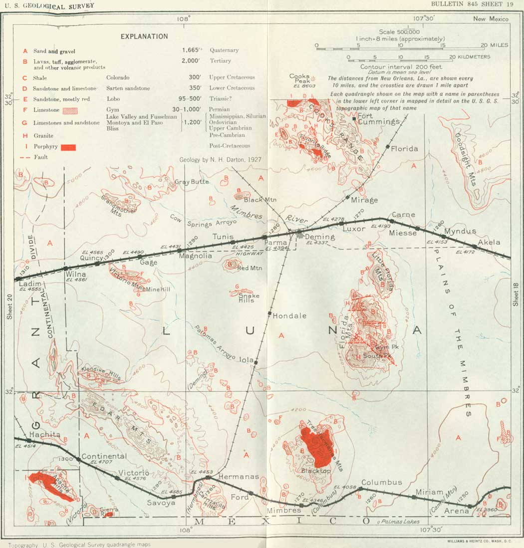
SHEET No. 19 (click in image for an enlargement in a new window) |
On approaching Arena siding (turn to sheet 19) the railroad descends nearly 200 feet into a wide, smooth-surfaced basin, or desert, which extends to Columbus and beyond. It slopes southward into Mexico and is occupied by Palomas Arroyo, a dry wash which is crossed 2 miles east of Columbus. This arroyo leads south into Palomas Lake, in Mexico, a water body due to springs known as Ojo de las Adjuntas (o'ho day las ad-hoon'tas), which come up in the valley bottom about 2 miles south of the international boundary.
|
Columbus. Elevation 4,058 feet. Population 391. New Orleans 1,262 miles. |
Columbus is a commercial center for agricultural and stock interests in the southern part of Luna County. A considerable area in the Palomas Valley north of Columbus is irrigated from wells which draw water from a widespread underflow contained in the gravel and sand that underlie the desert plain. Columbus is on a main road from Mexico and has a custom house and at times has had an encampment of United States troops. It was the scene of a noted raid by the Mexican outlaw Pancho Villa in 1915 and has witnessed many border episodes of greater or less importance.
About 20 miles north of Columbus are the Florida Mountains, the south end of which is plainly visible. This range is described on page 139. To the northwest are the Tres Hermanas Mountains (trace air-mah'nas, Spanish for three sisters), named from the three prominent conical peaks in the north end. The main feature of this range is a large intrusion of quartz monzonite porphyry which uplifts limestones of Permian age. There are also some masses of eruptive rooks of Tertiary age. Zinc ore has been produced in considerable amount from mines in the altered limestone near the porphyry contacts. Some of the geologic relations are shown in Figure 41. In the ridges north of Columbus a small amount of onyx was quarried at one time.
|
| FIGURE 41.—Section across Tres Hermanas Mountains, Luna county, N. Mex. Cg, Gym limestone (Permian); p, porphyry; r, rhyolite; b, basalt; q, quartzite; k, keratophyre |
From Columbus west the railroad continues across the great plain of valley fill and passes around the south end of the Tres Hermanas Mountains through Mimbres siding. Beyond Mimbres two small lava fields are crossed, apparently the product of rather recent eruptions. To the southwest are high mountains in the State of Chihuahua, Mexico.
|
Hermanas. Elevation 4,453 feet. Population 80.* New Orleans 1,281 miles. |
Hermanas is in the entrance to a low gap between the Carrizalillo Hills (ca-rree-sa-lee'yo) on the south and the Cedar Grove Mountains, a ridge which extends southeastward across the southwest corner of Luna County.21 Two miles beyond Hermanas are the Carrizalillo Springs, a very good example of underflow water brought to the surface by a ledge of hard volcanic rock which here crosses the valley. To the west is a wide desert valley draining south into the great basin of Lake Guzman, in Mexico. The international boundary is about 2 miles south of the tracks near Savoya siding. To the southeast of this siding is a high volcanic range in Mexico, a southern extension of the Carrizalillo Hills. Far to the southwest is the Sierra Boca Grande, also in Mexico.
21This ridge consists mainly of a succession of thin sheets of latite and other volcanic rocks of Tertiary age, dipping to the northeast at low angles. A basal agglomerate crops out along the southern foot of the summit. The latite continues past Carrizalillo Springs and also constitutes an outlying front ridge south of Hermanas station. Locally it is underlain by andesite. Next above the latite is 600 feet or more of agglomerate with included sheets of coarse pink rhyolite and minor flows of other high-colored lavas (andesite, urachyte, and latite) overlain locally by a thin sheet of fine-grained dark-gray keratophyre, a lava rich in soda and carrying little or no quartz. A ridge parallel to the main Cedar Grove Mountains, extending northwest from Hermanas for about 16 miles, consists of a thick sheet of dark lava (basalt) dipping northeast and lying on tuffs and other fragmental volcanic deposits. Basalt also occurs at other points in the vicinity of the mountains, where it appears to have been the product of the latest eruption. The southeastern part of the Carrizalillo Hills shows sheets of rhyolite tuff and agglomerate, dipping east and somewhat faulted. This complex succession of volcanic products indicates a remarkable variation in sources of eruption in a relatively short period of geologic time.
|
Victorio. Elevation 4,576 feet. New Orleans 1,294 miles. |
Near Victorio siding (named from the Apache chief referred to on p. 147), which is in the middle of the valley, the rounded slopes of the Cedar Grove Mountains extend along the north side of the valley, and the more rugged outlines of the Sierra Rica rise prominently to the southwest.22 About 1-1/2 miles west of Continental siding there is a sign reading "Continental Divide," but this is a mistake, as the basin of Hachita Creek, to the west, empties into the Rio Casas Grandes in Mexico, which, like other streams east to Arena, drains into Lake Guzman. This is, however, the highest point on the railroad west of the Rio Grande, being 4,745 feet above sea level. The Continental Divide is crossed 20 miles or so farther west. (See p. 168.) From this sign west there is a down grade to Hachita (ah-chee'tah). North of the track on this grade is a long, narrow ridge capped by lava (basalt), which probably originally flowed down a valley and protected the area which it covered, while the adjoining surface was being eroded to a lower level. This is an interesting example of an old stream bed at a higher level than the new ones.
22The Sierra Rica consists largely of blue-gray limestone of Comanche age, in part massive and in part thin bedded. The strata have a general dip of 4°-5° N. in most of the area, but to the south they bend over a low anticline with west-east axis which passes through a small gap a quarter of a mile north of boundary stone 39. These rocks contain Trinity fossils, but ledges in outlying buttes to the east and probably separated by a fault contain Exogyras of Washita age. The western part of the Sierra Rica consists of limestone of Pennsylvanian (Magdalena) age, which in outlying buttes to the west is overlain by gray quartzite of Comanche age; this rock is also conspicuous in a small ridge 10 miles due south of Hachita. A mile east of boundary stone 39 there is a mineral vein associated with a quartzite (probably of Trinity age) which yielded considerable silver-lead ore at the International mine, long since abandoned.
The Apache Hills, south of the railroad, consist mainly of intrusive quartz porphyry overlain by Tertiary volcanic rocks to the north and in contact with limestones of Comanche and probably Magdalena age to the south. There are several mines and prospects in the range; the largest is the Apache mine, which has produced considerable silver ore.
|
Hachita. Elevation 4,515 feet. Population 200.* New Orleans 1,305 miles. |
Hachita, in the broad Hachita Valley, is a small settlement, railroad junction, and headquarters for mining interests in the adjoining mountains. Several of the mines in the general region have had prosperity, and some are believed to hold considerable promise. The most productive mines are in the Sylvanite district, in the Little Hatchet Mountains, about 10 miles southwest of Hachita. (See sheet 20.)
|
|
SHEET No. 20 (click in image for an enlargement in a new window) |
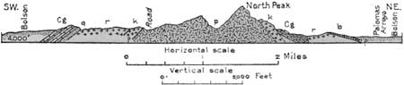
South of the Little Hatchet Mountains23 the much higher Hatchet Mountains are prominently in view, culminating in Big Hatchet Peak, 8,366 feet above sea level. They are of special geologic interest because they present an extensive succession of strata from Carboniferous to Cambrian lying on a floor of pre-Cambrian granite. The section in Figure 42 shows some of the relations. In the southwestern part of this range are thick beds of limestone, sandstone, and shale of Comanche age containing many characteristic fossils.
23The Little Hatchet Mountains present a considerable variety of rocks and complex geologic relations. The south end of the range is granite, which, however, may be of post-Carboniferous age, and this rock is exposed prominently in Granite Pass, 15 miles southwest of Hachita. Next north of that gap are ledges of sandy shale of Comanche age cut by a large granite dike. The higher central part of the range consists of a thick succession of limestones of the Magdalena group (Pennsylvanian) dipping southwestward and cut off to the north by a large mass of porphyry. In the northern part of the range are many prominent buttes and ridges of sandstone, shale, and limestone of Comanche age and several large masses of intrusive rock; in the vicinity of the Old Hachita camp limestone of the Magdalena group is exposed.
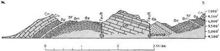
FIGURE 42.—Section across the north end of the Hatchet Mountains 20 miles south of Hachita. N. Mex. €b, Bliss sandstone (Cambrian); Oe, El Paso limestone (Ordovician); Om, Montoya limestone (Ordovician); Sf, Fusselman limestone (Silurian); Dp, Percha shale (Devonian); Clv, Lake Valley limestone? (probably Mississippian); Cm, limestones of Magdalena group (Pennsylvanian)
West from Hachita the railroad climbs a moderate grade of about 150 feet to reach the pass at the north end of the Little Hatchet Mountains. On the northern slope of these mountains near the railroad there are scattered exposures of dark shale of Comanche age. The ridge north of the railroad, of which Coyote Peak is the culminating summit, appears to consist mainly of Tertiary eruptive rocks. At its north end is a westward-trending ridge known as Quartzite Mountain, consisting of quartzites of Comanche age. A small but prominent butte a short distance north of this ridge is made up of limestone of the Magdalena group.
West from Vista siding the railroad descends 368 feet into a broad basin with a long, narrow lake bed or "playa" in its bottom. In wet seasons this basin is occupied by water, but usually the northern edge of the lake is some distance south of the railroad. At a time not very remote geologically a larger lake existed in this basin long enough for beaches and other shore features to develop. Its depth was about 40 feet. The lowest point on the margin of this basin is at Hatchet Gap which leads into the valley of Hatchet Creek. The fill in Playas Valley is probably very thick, and nothing is known of the configuration of its bedrock floor. An 836-foot well near its center was entirely in loam, sand, and gravel. These deposits contain considerable water, which is pumped for stock and domestic use and to a small extent for irrigation. At a ranch about 25 miles south of the railroad there is an artesian well yielding about 5 gallons a minute from a depth of 102 feet.
|
Playas. Elevation 4,311 feet. Population 20.* New Orleans 1,325 miles. |
Southwest of the Playas Valley are the Animas Mountains,24 a long rugged ridge consisting largely of lavas of Tertiary age in widespread sheets considerably flexed and faulted. In their higher parts is an extensive pine forest included in the Coronado National Forest. The Continental Divide is crossed on the inconspicuous summit a few miles west of Playas siding, at an elevation of about 4,515 feet. To the west of this point the drainage flows into the Animas River, which empties into the playas west of Lordsburg. These playas, on the rare occasions when they overflow, drain into the Gila River, which empties into the Colorado River and thus into the Gulf of California.
24On the central eastern slope of this range, southeast of a peak called Gillespie Mountain, limestone with Comanche fossils (possibly reworked) is extensively exposed; much if not all of it, however, is a conglomerate, and the materials may have been derived from near-by ledges of Comanche age. The ridges constituting the north end of the range 10 miles southwest of Playas siding consist largely of limestone of the Magdalena group (Carboniferous) and quartzite and shale of Comanche age. These strata are cut by large masses of porphyry which have been forced up in a molten condition.
|
Animas. Elevation 4,405 feet. New Orleans 1,336 miles. |
The detached ridges near the railroad between Antelope and Animas sidings are formed by Tertiary lavas. In this region there are fine views of the distant mountains, notably the Hatchet Mountains, 25 miles southeast. To the north are the Pyramid Mountains, which end just south of Lordsburg, on the north line of the Southern Pacific Railroad. According to Sauer and Brand25 remains of very old Indian settlements have been unearthed in the Animas Valley, and there is evidence that crops were raised on some of the larger flats, doubtless by the use of flood waters. One notable settlement, which covered 60 acres or more, was at a large spring west of Animas, which was dried up by the earthquake of 1887. Many types of pottery and other utensils were found in the vicinity.
25California Univ. Pubs. in Geography, vol. 73, No. 7, 1930.
There are ranches scattered along Animas Valley which obtain water from wells in the valley fill. Some water, mostly pumped by gasoline engines, is used for irrigation.
|
Pratt. Elevation 4,425 feet. New Orleans 1,341 miles. |
Between Animas and Pratt sidings the railroad crosses a sheet of black scoriaceous basalt, a local lava flow of relatively recent age. Several low cinder cones mark vents through which the lava reached the surface. About 2 miles west of Pratt sandstone of Comanche (Lower Cretaceous) age constitutes a ridge extending for a mile or more along the east slope of the mountain just north of the railroad, and a short distance northeast of this ridge, or about 1 mile northwest of Pratt, is a conical butte of limestone of the Magdalena group.
West of these features the railroad passes through Antelope Pass, a deep gap in the Peloncillo Mountains, and descends about 450 feet into the San Simon Valley, which drains into the Gila River. This mountain range extends for about 100 miles along the southwestern margin of New Mexico and consists mainly of Tertiary lava flows similar to those constituting the Animas Mountains and many other ranges, in a thick succession, which is considerably flexed and faulted. Heavy beds of massive lava26 and tuff lying nearly horizontal are well exposed on the north side of the gap. There are also necks and craters which were sources of outflow, but the region has been so deeply eroded since the time of eruption that the volcanic history is difficult to decipher.
26Rhyolite with phenocrysts of quartz and orthoclase, as determined by C. S. Ross, of the U. S. Geological Survey.
About 12 miles north of Antelope Gap is Granite Gap, through which highway 80 crosses the Peloncillo Mountains in a low pass. Here the rocks underlying the Tertiary succession are revealed rising in a large mound in the center of the range.27
27The El Paso limestone, here exposed, presents the same features as in the Franklin Mountains, near El Paso, but is much thinner. A massive dark limestone 30 feet thick strongly suggests the Fusselman. It is overlain by 100 feet of dark shale, probably Percha (Devonian), which is capped by limestones similar to the Escabrosa (Mississippian) of southeastern Arizona. The Magdalena group is well represented by overlying limestone, the outcrop of which extends far to the north. The granite is exposed in an area of about 1 square mile.
|
Rodeo. Elevation 4,119 feet. Population 160.* New Orleans, 1,353 miles. |
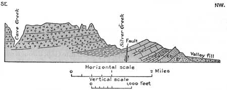
Beyond Antelope Gap the railroad bends southward and ascends the broad alluvial valley of San Simon Creek in order to pass around the south end of the Chiricahua Mountains. This high rugged range, rising grandly to the west of the railroad, presents an intricate mass of high peaks and a steep mountain front deeply notched by canyons. The higher part of the range is made up of a thick succession of lava flows which lie on an irregular floor of Paleozoic and Mesozoic limestones, sandstones, and shales. There are many faults, flexures, overlaps, and other features that have not been mapped in detail. A very interesting section of the strata 28 is presented in the foothills north of Portal, Ariz., a small settlement and resort 10 miles northwest of Rodeo. (See fig. 43.)
28The limestones of Carboniferous age include the Escabrosa (lower Mississippian), overlain by about 134 feet of beds in which, near the abandoned mining camp of Paradise, Stoyanow has discovered an interesting assemblage of upper Mississippian fossils; next occur about 3,500 feet of Naco limestone, largely of Pennsylvanian age, but at its top, overlying a 100-foot quartzite member, are 500 feet of limestones in which Stoyanow has collected Productus ivesi, P. occidentalis, Meekella pyramidalis, Squamularia guadalupensis, and Aviculopecten coloradoensis, a typical Kaibab fauna of Permian age.
|
| FIGURE 43.—Section of northeastern foothills of Chiricahua Mountains near Portal, Ariz. €b, quartzite with sills of rhyolite (Cambrian); €a, thin-bedded limestone and shale (Abrigo); Ce, limestone (Devonian and Carboniferous); K, sandstone, limestone, and shale (Comanche, Lower Cretaceous); Tv, lava (latite, Tertiary), dipping south at a low angle; gr, granite. |
The canyon of Cave Creek just above Portal has been called the Yosemite of Arizona, on account of its great beauty. It is walled with magnificent white cliffs 1,000 to 2,000 feet high, which have been eroded into a great variety of castled and pinnacled forums. The rock is a massive latite, the product of a great volcanic outflow in Tertiary time. The canyon is extremely narrow and tortuous and contains a charming typical mountain stream. There is a good road extending up the canyon and finally crossing the mountain to Sulphur Spring Valley. This mountain region is embraced in one of the divisions of the Coronado National Forest, for the higher portions are covered with pine and other timber. Much of the mountain land is also used for grazing of large numbers of cattle, sheep, and goats. Six miles above Portal is Crystal Cave, in limestone (Comanche), which has been only partly explored, and on the west slope are many remarkable pinnacles and other erosion forms developed in the lavas. In various parts of the east front of the mountain there are remains of cliff dwellings, and many of these have also been found in the cliffs of the great succession of volcanic rocks constituting the Peloncillo Mountains east of Rodeo and in the upper part of San Simon Valley. Evidently there was an aboriginal population of considerable size in this region, and it was also a great resort for the Indians of later times, who found water and good hiding places in the numerous canyons.
In the San Simon Valley at Rodeo and for some distance above and below considerable water is available in the sand and gravel of the valley fill, mostly at depths of 300 to 400 feet. It has been extensively utilized by wells and the water applied to irrigation with excellent results. According to Schwennesen most of the wells penetrate two water-bearing beds, and some of them more. In the central part of the valley, in the vicinity of Rodeo, the first water-bearing beds are from 70 to 80 feet deep, the second from 90 to 100 feet, and the third at about 150 feet. Near Apache the depths are slightly greater. In the San Simon Cienega, 15 miles north of Rodeo, the water comes to the surface in a small area. A well pumped at Rodeo station yields about 200 gallons a minute, and at that rate the water level is lowered 22 feet. The total solids in the well water of this region are only 160 to 364 parts per million, and the principal salt is sodium carbonate.
|
Chiricahua. Elevation 4,671 feet. New Orleans 1,374 miles. |
Two miles southwest of Rodeo the State of Arizona (see p. 147) is entered. The course of the railroad is S. 30° W. through Mora and Apache sidings and nearly to Chiricahua siding, ascending the wide grassy flat-bottomed valley of San Simon Creek. It skirts the bold east front of the Chiricahua Mountains, broken by deep canyons up which are vistas of the high central range with its forest covering. From a point near Mora siding there is an especially fine view of this kind up Horseshoe Canyon. East of the railroad are the steep slopes of the Peloncillo Mountains, consisting of volcanic rocks similar to those on the opposite side of the valley. They lie nearly horizontal, although northeast of Rodeo the succession is tilted to the southeast. Beyond Apache a prominent butte (Squaw Mountain) west of the railroad shows a block of part of the volcanic succession dipping east and probably separated by faulting along its west side. Near by are the remains of a very old Indian settlement of considerable extent. Not far beyond Apache siding the headwaters of the San Simon Valley are crossed, and here begins a flow of black lava (basalt) which occupies a wide area in the valley and extends south to the international boundary.29 The lava is very fresh and evidently the product of an eruption in Recent geologic time from vents now marked by cinder cones, several of which are visible not far east and southeast of Bernardino siding. The relations of the scoria, bombs, and lapillae in one of these cones are well exposed by a quarry and cut a few miles beyond Chiricahua siding. Between two cones 5 miles southeast of Chiricahua siding is a very remarkable crater closely similar in character to the Kilbourne Hole and Hunts Hole, southwest of Lanark. (See p. 134.) Its rim is dimly visible from the railroad. It is a huge oblong hole a mile long and about 200 feet deep. The bottom, now a smooth surface of alluvium, is encircled by a wall of lava of the flow that constitutes the surface of the surrounding country and was probably derived from craters marked by cones to the north and south. Upon this wall is an encircling rim, in places 150 feet high, of fragmentary material, lava, cross-bedded sand, or soft sandstone and many fragments of limestone containing Comanche fossils from strata that underlie the valley and crop out in it not many miles southeast of the crater. (See fig. 44.) This feature is believed to have been caused by a volcanic explosion after the lava flow.
29The lava is black and cellular, and although the sheet is not very thick it presents a surface of extreme irregularity, closely resembling some of the recent flows in other parts of the world. Apparently most of the lava welled out of cracks and spread over the bottom of the valley. As its area widened the surface congealed and the hot lava broke out from underneath, causing tunnels and irregular caved-in areas. That the molten lava was filled with steam is shown by the scoriaceous or honeycombed character of the rock. Many of the details of flow are clearly shown by the surfaces, which in some places are ropy, as the lava puckered in congealing, and in others are glassy and smooth like slag from a blast furnace. Many of the tunnels are extensive, and there are also innumerable huge bubbles or blisters more or less cracked by deep fissures due to the contraction caused by cooling. Some flows also have deep crevices due to great emissions or explosions of steam. The margin of the flow presents an irregular edge of low cliffs, such as is shown in Plate 19, A, consisting largely of great masses of broken fragments, formed as the congealing lava was pushed along by the advance of the flow. In places a cinder cone was built up at the end of the eruption, undoubtedly marking the location of an orifice. In its last stages the action was mainly a violent escape of steam, which blew out a large amount of cindery or pumiceous material, together with a few hardened masses of lava. This was all thrown to a considerable height in the air and then fell on all sides, quickly building a cone. The recent date of these eruptions is indicated by the fact that the piles of loose material have not been affected by the powerful erosional processes of the region, and there is no perceptible oxidation of the rocks or cinders; the lava still shows the jagged edges due to accidents of flow, and there are many minute stalactites of lava hanging in the roofs of the tunnels. Also, the lava and cinders lie on sand deposits that are of Recent age.
|
| FIGURE 44.—Section across explosion crater 5 miles southeast of Chiricahua siding, Cochise County, Ariz. |
This region is called the San Bernardino Valley from an early settlement at the San Bernardino ranch (now the Slaughter ranch), on a Spanish land grant that straddled the present international boundary. The ranch house is about 10 miles southeast of the railroad. A main road to the west, laid out by Lieutenant Colonel Cooke and the Mormon Battalion, a division of General Kearny's Army of the West, went through this place in 1846 and, passing near Douglas, followed down the San Pedro River to Benson. This road became part of the great emigrant trail of the West, and its existence and relations to a possible railroad route had much to do with the Gadsden Purchase.
In prehistoric times the part of San Bernardino Valley near the springs was occupied by Indians who lived in settlements of considerable size. According to Sauer and Brand, there are many remnants of foundations and "cimientos," or cobblestone walls, and abundant fragments of pottery, implements, ornaments, and a few corn cobs; potteries of various types indicate long occupation and commerce far to the north, south, and east. Probably mesquite beans were the most important food element to these people, but they raised crops on some of the more favorable soils.
|
|
SHEET No. 21 (click in image for an enlargement in a new window) |
Beyond Perilla siding the railroad skirts a lava-covered mesa and, leaving the broad San Bernardino Valley by a huge horseshoe bend, ascends the rocky valley of Silver Creek to a divide at Cazador siding. (See sheet 21.) Near Silver Creek siding sand and conglomerate are exposed under the lava sheet, and volcanic rocks of Tertiary age appear. These rocks present striking exposures in the ridges about South College Peak, where there is a cap of massive latite with strongly marked columnar structure on a large scale. A feeder dike trending east from the foot of the ridge is noticeable 1-1/2 miles south of Silver Creek siding. Near Cazador siding Castle Dome, a huge plug of latite, is visible 5 miles to the north. From this point the course of the railroad is mostly south and southwest over Tertiary volcanic rocks.
|
Lee. Elevation 4,411 feet. New Orleans 1,396 miles. Douglas. Elevation 3,980 feet. Population 9,828. New Orleans 1,405 miles. |
At Lee siding the railroad passes between two knolls of limestone of Comanche age, which underlies or is faulted against the volcanic rocks, and enters the southern portion of Sulphur Spring Valley. In this vicinity this valley is drained by Whitewater Creek, flowing southeast into Mexico, where it finally empties into the Rio Bavispé, a branch of the Yaqui River, which empties into the Gulf of California near Guaymas.
On approaching Douglas the first visible objects are the high stacks of the two large smelters, the Copper Queen and the Calumet & Arizona, on the western edge of the city, where copper ores from Bisbee and other places are treated. Douglas lies near the middle of the wide plain of the southern extension of Sulphur Spring Valley. The valley plain here is about 20 miles wide and extends northward 60 miles to and beyond the main line of the Southern Pacific Railroad in the Willcox region. (Seep. 156.) It is deeply covered by sand and gravel washed from the adjoining mountain slopes and known to be nearly 1,000 feet thick. The configuration of these intermontane valleys is highly characteristic, the smooth surface sloping gently up to the foot of the mountains, which rise abruptly with steep rocky slopes. To the east the rugged ridges of the Chiricahua Mountains are visible; 25 miles due north are the Swisshelm Mountains, which consist largely of Paleozoic rocks; and to the west are the Mule Mountains, which rise more than 3,000 feet above the valley and in which the great copper mining center of Bisbee is situated. To the south in Mexico are many high mountains and peaks, mostly of volcanic rock. One conspicuous conical peak to the southeast on the international boundary is the place where the notorious outlaw Pancho Villa assembled his forces before attacking Agua Prieta in 1915
Douglas is on highway 80, which continues west through Bisbee and Tombstone. The city extends south to the international boundary and the small town of Agua Prieta, Mexico (population 2,500), with which it shares an international airport. Douglas, which ranks third in population in Arizona, is a port of entry from northern Sonora, Mexico, with extensive imports. Railroads branch here to Nacozari, in Sonora, where there are large copper mines, and northward up Sulphur Spring Valley to the mining towns of Gleeson, Courtland, and Pearce to join the north line of the railroad at Cochise, 59 miles away. The mines about Gleeson and Courtland are on the east slope of the Dragoon Mountains, in the Turquoise district, so called because turquoise was obtained from the quartzite and granite, mainly by the Indians, who greatly value the blue-green mineral as a medicine stone. The mines, which have been worked to moderate extent since 1883, have produced considerable gold, silver, lead, and copper, and the value of the copper output is more than $8,000,000.30
30The rocks exposed in this vicinity comprise the Pinal schist (Archean), Bolsa quartzite and Abrigo limestone (Cambrian), limestone of Carboniferous age, sandstones of Cretaceous age, and porphyries, granite, and rhyolites of post-Carboniferous age. The rocks are flexed and faulted and also displaced by a remarkable overthrust by which schist and Cambrian strata are carried onto Carboniferous limestone. The ores were formed principally by replacement of the limestone. (E. D. Wilson.)
Douglas was named for Dr. James Douglas, who had much to do with the development of the copper industry of the Bisbee district, and it had the advantage of being planned as a city with the definite object of being a smelter and trade headquarters. It began in 1900. The water supply is obtained from wells 3 miles distant.
On leaving Douglas the smelters are passed (south of the railroad), with their huge piles of black slag resulting from the copper smelting. According to the United States Bureau of Mines, in 1928 these smelters had a joint output of 271,400,000 pounds of copper, 5,970,118 ounces of silver, 105,641 ounces of gold, and 14,500,000 pounds of lead, the largest copper-smelting output at any one place in the West. About 1,500 men are employed, many of whom live in the suburb of Pirtleville. In a short distance the railroad crosses Whitewater Draw and ascends the west slope of the wide valley. Near Forrest there are buttes of eastward-dipping limestone of Comanche age (Mural limestone), outliers of the large mass of Comanche strata which constitute the east side of the Mule Mountains.31 In one of these buttes a short distance west of Forrest is the large Paul lime quarry. The railroad passes around the south end of this range, which shows a few rocky ledges, and crosses the Espinal Plain, which is occupied by gravel and sand.
31In the Mule Mountains the Comanche series comprises the following formations:
Feet Cintura formation; red, nodular shales with cross-bedded buff, tawny, and red sandstone; a few layers of impure limestone near base (surface eroded) 2,800 Mural limestone; upper member massive hard gray limestone; lower member thin bedded and sandy 650 Morita formation; buff, tawny, and red sandstone, some hard, alternating with dark-red shale; a few thin layers of impure limestone near top 1,800 Glance conglomerate; bedded conglomerate with rather angular pebbles, chiefly schist, chert, and limestone of local origin (unconformably on older rocks) 50-75
|
Bisbee Junction. Elevation 4,676 feet. New Orleans 1,427 miles. |
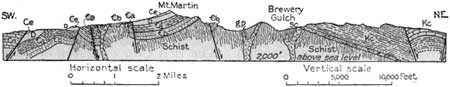
At Bisbee Junction there is a branch railroad to Bisbee, 8 miles north, which passes the great concentrating plant of the Copper Queen Co. Bisbee,32 a prosperous city in the Mule Mountains, is built in a most picturesque fashion in the narrow crooked canyon and along the precipitous slopes of Mule Gulch. It began as a lead camp with small production. The rich Copper Queen ore body was discovered in 1878 and for a few years yielded ore averaging 23 per cent of copper. When this ore was worked out new bodies of lower grade ores were found which have continued to produce a large tonnage, and in 1902 other ore bodies were revealed by the Calumet & Arizona mine. The workings are large and of considerable depth, but all lie in an area of less than a quarter of a square mile. (Ransome.) According to the United States Bureau of Mines about 32,250,000 tons of material has been removed from Sacramento Hill, most of it low-grade ore. About 3,000 men are employed. The copper production of the several mines in 1929 was 186,130,352 pounds, which, together with considerable gold, silver, and lead as by-products, had a value of $35,504,798. The most extensive ores are sulphides, oxides, and carbonates. In 1929 their average value in metals was near $12 a ton.
32The formations at Bisbee comprise Pinal schist, Bolsa quartzite, Abrigo, Martin, Escabrosa, and Naco limestones, Comanche series, and igneous granites. The Pinal schists, which are believed to have been originally shales and arkosic sandstones, were folded and metamorphosed to their present crystalline condition in pre-Cambrian time. They are cut by granite and quartz porphyry, which were intruded in a molten condition. The basal Paleozoic formation, lying unconformably on the schist, is the Bolsa quartzite. It is from 400 to 500 feet thick and is overlain by about 750 feet of slabby Abrigo limestone, which has many intercalated cherty layers and is in turn overlain by white limestone, in which Stoyanow has recently discovered many trilobites of Upper Cambrian age. The Martin limestone, 300 to 350 feet thick, is of later Devonian age. Ordovician, Silurian, early Devonian, and later Mississippian time are not represented. The early Mississippian is represented by the Escabrosa limestone, 700 feet thick, and the Pennsylvanian and Permian by the Naco limestone, about 3,000 feet thick. These rocks are overlain unconformably by a thick succession of Lower Cretaceous (Comanche) rocks comprising, at the base the Glance conglomerate, 25 to 500 feet; Morita formation of sandstones and shales, 1,800 feet; Mural limestone, massive above and thin-bedded and in part sandy below, 650 feet; and at the top the Cintura formation, shales and sandstones, 1,800 feet or more. There has been general uplift of the strata with considerable faulting at two or more periods, and erosion has bared the various rocks, in places down to the basement of Pinal schist. The Lower Cretaceous beds were deposited on an unevenly eroded surface of the uplifted rocks, and they in turn have been uplifted, faulted, and eroded. Prior to this epoch of disturbance considerable granite and porphyry were intruded and had much to do with the beginning of mineralization, which progressed at later times. (Ransome.)
The mean annual precipitation in this region is from 18 to 20 inches.
|
| FIGURE 45.—Section across the Bisbee region, Ariz. Kc, Limestones, sandstones, shales, and conglomerate of Lower Cretaceous age (Comanche); Cn, Neco limestone; Ce, Escabrosa limestone; D, Martin limestone (Devonian); €a, Abrigo limestone; €b, Bolsa quartzite (Cambrian); sc, schist; gp, granite porphyry. After Ransome |
|
Naco. Elevation 4,578 feet. Population 422. New Orleans 1,431 miles. |
Naco33 is in the wide Espinal Plain (es-pee-nahl'), which slopes west from the foot of the Mule Mountains into the broad valley of the San Pedro River. This river rises in Mexico, flows north, and finally empties into the Gila River. The San Pedro Valley has had an interesting history, having long been a natural passageway for explorers, travelers, and Indians, including De Niza and Coronado. (See p. 150.)
33In March, 1929, Naco, Mexico, just across the boundary from Naco, Ariz., was the scene of a severe battle between Mexican troops and revolutionists, in which the latter, by the aid of bombs dropped from airplanes and attacks by tanks, were victorious.
In 1692, on his first visit, Padre Kino (see pp. 161, 186) named the river Quiburi (kee-boó-ree) from a ranchería of about 500 Indians, near the river not far from Tombstone. It was the home of Coro, the head Pima chief, and it was here that Kino on the expedition of 1697 found the Indians dancing about some Apache scalps they had just obtained. Later American and Mexican settlers in the valley were greatly harassed by hostile Indians, until the final subjugation of the Apaches in 1886. The earliest American settlers were four Mormon families from the colony established near Mesa, Ariz., by Brigham Young in 1878. These settlers founded St. David. It was down the San Pedro Valley in 1846 that Colonel Cooke laid out the military road to the West that was used extensively by later travelers. His troops were made up largely of Mormons who entered the service in order to reach California, where their term of enlistment would end.
|
Hereford. Elevation 4,189 feet. Population 221. New Orleans 1,443 miles. Lewis Springs. Elevation 4,027 feet. New Orleans 1,453 miles. |
The railroad reaches the bottom of the San Pedro Valley at Hereford and follows it northward to Benson. Near Hereford and for some miles north the prominent Huachuca Mountains (wah-choo'ca) form the west side of the valley, attaining an elevation of over 9,000 feet in Miller Peak and Carr Peak. It is included in a division of the Coronado National Forest. At its north end is Fort Huachuca, a frontier military post reached by a 13-mile branch railroad from Lewis Springs.
The San Pedro Valley is from 15 to 20 miles wide in greater part, and with steep lateral slopes and a declivity of nearly 600 feet in 40 miles it is very different in character from the basinlike Sulphur Spring Valley, which lies a few miles east. This difference is due to the erosion of a vigorous river which trenches deeply into the thick valley fill, especially in the region below Lewis Springs. At Lewis Springs and at intervals northward porphyry is revealed in the valley bottom, which is apparently on the crest of an underground ridge connected with the porphyry area so extensively exposed about Tombstone. This noted mining camp lies 8 miles east of the main railroad and is reached by a branch line from Fairbank, where there is also a branch railroad leading to Patagonia.
Tombstone is on the gentle slopes of the Tombstone Hills, overlooking the San Pedro Valley. The ore deposits34 were discovered by Ed. Schieffelin almost by accident in 1878, the great strike occurred in 1879, and the town was established in 1881 with the name Tombstone because someone predicted to Schieffelin that his prospecting would yield only a tombstone. The Silver King was a famous producer of rich ore which assayed $2,200 and some of it even $9,000 in silver to the ton. Later several rich mines were combined and operated profitably until flooding of the largest mine threw the company into legal difficulties, during which most people left Tombstone. After years of litigation the principal group of mines was sold at auction for $500,000, and production at Tombstone was resumed in a small measure, for a time. After the silver mines were abandoned it was found that the associated deposits of manganese ore could be marketed, and in 1918 the old Oregon mine was producing about 2,000 tons a month of this ore for use in small proportions in iron making to improve the quality of the pig iron. Tombstone is now a city of 850 inhabitants with hopes that additional ore bodies will be discovered some day and restore the former prosperity. It is the scene of the Wolfville stories of Bret Harte and many other books and stories by various authors and the place where the famous newspaper "The Arizona Kicker" was published; the present newspaper bears the name "Tombstone Epitaph." Its historic "Bird Cage Theater" in boom days housed some great actors.
34According to Ransome the Tombstone mining district presents a local uplift of Paleozoic rocks lying on a basement of pre-Cambrian schist and granite and overlain by sandstone, shale, and limestone of Lower Cretaceous (Comanche) age. There are also larger masses of granitic rocks and porphyry that cut all the strata, causing considerable metamorphism, which apparently had much to do with the deposition of the rich silver ores in the limestone. The basal strata are 440 feet of Bolsa quartzite and 700 feet of Abrigo limestone (both Cambrian). Next above are 340 feet of Martin limestone (Devonian), 500 feet of Escabrosa limestone (Mississippian), and 2,000 to 3,000 feet of Naco limestone (Pennsylvanian and Permian). There is much faulting. The greater part of the silver ore was found in the limestone of the overlying Comanche series, partly as replacement deposits in the limestone and partly in fissures. Some ore occurred in altered porphyry dikes. The largest replacement ore bodies were mostly in the anticlines in the vicinity of dikes or fissures. The manganese ore occurs as a replacement deposit in the Naco limestone.

|
|
SHEET No. 22 (click in image for an enlargement in a new window) |
|
Charleston. Elevation 3,971 feet. Population 25.* New Orleans 1,457 miles. Fairbank. Elevation 3,853 feet. Population 197. New Orleans 1,464 miles. |
The small village of Charleston, on the banks of the San Pedro River, at one time had a smelter and was noted as a wild frontier town. From Fairbank the railroad ascends the west side of the San Pedro Valley and passes northwestward around the northeast side of the Whetstone Mountains (p. 161). (Turn to sheet 22.) At Mescal it crosses (on a bridge) the old main line of the Southern Pacific, now used for eastbound traffic between Tucson and Mescal, and is joined by the line from El Paso by way of Deming, Lordsburg, and Bowie.
| <<< Previous | <<< Contents >>> | Next >>> |
bul/845/sec21a.htm
Last Updated: 16-Apr-2007