 | ||
 | ||
 | ||
 | ||
 | ||
 | ||
 | ||
 | ||
 | ||
 | ||
 | ||
 | ||
 | ||
 | ||
 | ||
 | ||
 |
 |
 |
Colonial Parkway
Jamestown, Williamsburg, Yorktown, Virginia
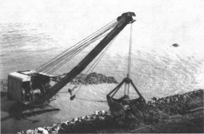
Laying of rip rap for seawall construction along the York River, 1935. (COLO) |
ENGINEERING IN THE TIDEWATER REGION
The decision to align the parkway along the rivers provided landscape architects dramatic scenic possibilities, but it challenged builders who had to traverse tidal marshes with a modern highway. Like the Mount Vernon Memorial Highway, extensive use of hydraulic fill was required to create a suitable roadbed at an elevation of eleven feet above sea level. Over three miles of the parkway was constructed on dredged material which requires constant maintenance (on the Jamestown portion) to repair damage caused by settling.
In 1933, three concrete deck bridges were constructed over Indian Field, Felgates, and Kings creeks along the York River. The bridges simple, low-level designs blend with the surrounding environment of coastal bluffs and marsh grasses, providing unobstructed views in all directions. These bridges became the model for stream and marsh crossings along the entire parkway route. Due to the region's unconsolidated soil, unusually deep foundation piles were required for all the structures.
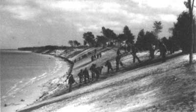
Workers grade river slopes prior to placing sod to control erosion, 1935. (COLO) |
COLONIAL LANDSCAPE
Landscape architects integrated the region's natural and cultural resources into the overall design of Colonial Parkway. To create the "colonial atmosphere" thought necessary for visitor experience, culvert headwalls and parkway underpasses were clad in antiqued "Virginia-style" brick laid in English and Flemish bonds. In the vicinity of Williamsburg, numerous grade separation structures were required to bypass the region's expanding road system. These simple, brick-clad arched bridges reinforce colonial themes and are perhaps the most characteristic features of the parkway. A labor intensive process of brooming and acid washing was used to expose the aggregate in the pavement to simulate the shell and marl roads of colonial Yorktown.
In 1932, NPS landscape architect Edward Zimmer developed a planting plan that guided tree placement and vista development. Four Civilian Conservation Corps (CCC) camps were established in Yorktown in 1933, one of which was involved in parkway planting operations. Pines, cedars, dogwoods, redbuds, tulip and beech trees were planted along slopes to create a "natural" environment along the road. Special attention was made to create a canopy cover along the Yorktown to Williamsburg stretch in order to provide a shady tunneling effect.
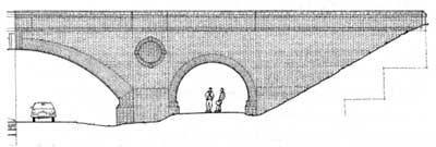
Detailed rendering of the C&ORR underpass with its colonial-style brick facing. (Harlen Groe/HAER) |
COUNTRY ROAD VS. MODERN PARKWAY
In response to the parkway's modern design, park superintendent William Robinson, Jr. (1931-1933) advocated the incorporation of steeper grades and irregularities of alignment to create a "country road" feel more representative of colonial-era road building. Despite Robinson's efforts, NPS officials decided to continue its efforts to construct a modern parkway. A more controversial issue, however, arose concerning routing of the parkway in the vicinity of Williamsburg.
| Introduction | Acadia | Blue Ridge Parkway | Colonial Parkway | Generals Highway | George Washington Memorial Parkway | Great Smoky Mountains | Mount Rainier | Rock Creek and Potomac Parkway | Shenandoah's Skyline Drive | Southwest Circle Tour | Vicksburg | Yellowstone | Yosemite | Discover History |
