 | ||
 | ||
 | ||
 | ||
 | ||
 | ||
 | ||
 | ||
 | ||
 | ||
 | ||
 | ||
 | ||
 | ||
 | ||
 | ||
 |
 |
 |
Colonial Parkway
Jamestown, Williamsburg, Yorktown, Virginia
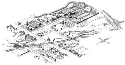
Aerial view of Williamsburg, showing alignment of tunnel through the historic district. (Robert Harvey, HAER) |
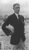
Arthur Shurcliff, landscape architect for Colonial Williamsburg, was active in parkway issues in the vicinity of Williamsburg during the 1930s. (CW) |
THE WILLIAMSBURG TUNNEL
As early as 1930, questions concerning the role of Williamsburg within the Colonial National Monument strained relations between the two organizations as Williamsburg Foundation officials voiced their objections to a modern parkway intruding upon the historic capital.
Two routes emerged which came to be know as the "Shurcliff Line" north and west of the city, named for Foundation landscape architect Arthur Shurcliff, and the "Peterson Line" east and south of the city, named for Charles Peterson. For Peterson, the route east and south of Williamsburg was more open, and balanced the York River section with sweeping views of the James River. This alignment, however, crossed the property of Bassett Hall which was purchased by Rockefeller as a family home. For Colonial Williamsburg the "Shurcliff Line" became a way of avoiding Rockefeller's home, but it neglected the balanced character of Peterson's original alignment.
Debate continued until the spring of 1936, as the parkway approached Williamsburg with brick-clad, arched overpasses at Capital Landing Road and the Chesapeake & Ohio Railroad and Lafayette Street crossings just north of town. A proposal to construct a tunnel under Williamsburg, advocated by prominent Wiliamsburg citizens, took most people involved with the project by surprise. Although initially discounted as too ambitious, traffic consultants saw it as the most effective way to bypass Williamsburg.
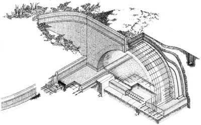
Cutaway isometric of Williamsburg Tunnel, (Robert Harvey, HAER) |
Cut-and-cover construction was employed to build a 30-foot wide reinforced concrete tunnel. Earth was excavated along the route, requiring certain structures to be moved or supported while the tunnel's concrete shell was poured. Upon completion of the lining, earth was then placed over the structure and landscaped. Poor supervision and heavy rains that caused numerous cave-ins hampered construction and turned public opinion against the project. Although completed by 1942, the tunnel did not open for traffic until 1949.
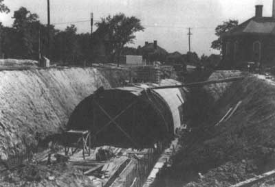
Tunnel under construction through the Courthouse Green, 1930s. (CW) |
| Introduction | Acadia | Blue Ridge Parkway | Colonial Parkway | Generals Highway | George Washington Memorial Parkway | Great Smoky Mountains | Mount Rainier | Rock Creek and Potomac Parkway | Shenandoah's Skyline Drive | Southwest Circle Tour | Vicksburg | Yellowstone | Yosemite | Discover History |
