


Historical Background
| July 30-August 13 1805 |
Whither the Shoshonis?
Pushing southwestward up the Jefferson on July 30, the group faced a desperate situation. In fact, without the Shoshonis, it was lost. Indeed, not one Indian had been met since leaving the environs of Fort Mandan early in April. Many signs of them had been seen along the riverbank after leaving the Great Falls, and smoke signals had been sighted. Some of the abandoned campsites were old, probably dating from the previous autumn, but others appeared to have been vacated only a few days before. Indians had likely seen the intruders, but none made an appearance.
Although Sacagawea had recognized the country as they approached the Three Forks, on arrival she did not know which of the three streams led to the western mountains. She did recognize the campsite near the junction of the Jefferson and Madison as the spot where her village had been encamped 5 years earlier when the Minitaris attacked it. She also knew the place where she had been captured, about 4 miles farther up the Jefferson.
The expedition had moved only 3 days up that beaver-infested and island-studded stream when Clark celebrated his 35th birthday, on August 1. It was not a particularly joyous one, for his feet were still badly lacerated and a huge boil festered on one ankle. Confined to the canoes, he could not walk any distance.
In view of Clark's indisposition, that same morning Lewis, Drouillard, Charbonneau, and Sergeant Gass set out overland, scouting frantically for any sign of Shoshonis. Near the present city of Twin Bridges, Mont., the explorers came to a fork in the Jefferson and turned up the western one, the Big Hole River. Before long, realizing they were not on the main stream, they turned back and followed the other fork, the Beaverhead River, an extension of the Jefferson.
Meanwhile, Clark and the canoes had been struggling up the ever shallower and narrower Jefferson, which had become a mountain rather than a plains river. He was still barely able to walk. Everyone was worn out; sickness and despondence were common; game grew scarcer. In a misadventure on August 5-6 the group went up the same stream, the Big Hole, that Lewis had mistakenly taken a few days before. Unfortunately, a beaver had chewed down a pole to which Lewis had fastened a note directing Clark.
In a rapids one of the canoes upset and two others partially filled with water. Whitehouse was badly hurt; 20 pounds of powder were lost; many provisions were damaged and some were not recovered. After Drouillard found the astray men on the 6th and told them they were following the wrong stream, they retraced their way to the fork, proceeded up the Beaverhead, and reunited with the Lewis party. The next day, because of the reduction of the cargo, one of the canoes was hidden and left behind.
On August 8 Sacagawea created a stir of excitement when she recognized far in the distance on the west side of the river the features of Beaverhead Rock, usually known today as Point of Rocks and located 14 miles northeast of Dillon, Mont. She said it was not too distant from the summer retreat of her people, which was located on a westward-running river (Lemhi) beyond the mountains. She said her tribe would be on the Beaverhead River or on the river (Lemhi) immediately west of its source.
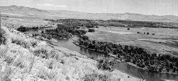 |
| Jefferson River, looking downstream to the northeast, from a point about 8 miles southwest of Three Forks of the Missouri, Mont. When the explorers passed through this area, they were eagerly seeking the Shoshonis, whom it was hoped would provide help in crossing the mountains to the west. (National Park Service (Ray H. Mattison, 1958).) |
Intensifying the search for the Shoshonis
Lewis, excited, decided to make a second attempt to push on ahead on foot to find the Shoshonis. Anxiety about contacting this tribe had by now increased greatly. The next morning, at a point about 21 miles north of present Dillon, Lewis, Drouillard, Shields, and McNeal set out. Each of them was allowed to carry only one blanket and his weapons; their packs were filled with Indian trade goods.
The next day, the 10th, coming upon an Indian trail, the group followed it upstream. It led past high cliffs, on both sides of the river. Lewis named them Rattlesnake Cliffs (known locally today as Beaverhead Rock) because of the large number of rattlers in the vicinity. About 15 miles farther was a fork in the Beaverhead, into which flowed Horse Prairie Creek and the Red Rock River. The trail also forked at this point, one branch going up each stream. After some investigation, the party followed Horse Prairie Creek, the western fork leading toward the mountains, rather than the other, which flowed from the southeast. But, recognizing the insufficiency of water in both streams for navigation, Lewis left a note for Clark at the fork for him to stop and await his return. Five miles from the fork, the men made camp in a mountain cove, Shoshoni Cove.
Continuing on the next day, the party soon found that the Indian trail disappeared. Lewis sent Drouillard out on one flank and Shields on the other, but still within sight, and instructed them to watch for the trail as they advanced toward a pass (Lemhi) through the mountains (Beaverheads) they had seen to the west. They proceeded this way for about 5 miles. Lewis suddenly viewed about 2 miles ahead a lone horseman coming down the plain toward the group— the first Indian encountered since leaving the Mandan village area in April.
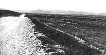 |
| Shoshone Cove, Mont., looking westward. Horse Prairie Creek, rising in the distance near the Continental Divide, drains this region and empties into the Beaverhead River about 5 miles to the east, or rear, of the point from which this photograph was taken. In this cove, Lewis and his three companions saw their first Shoshoni, who when the four approached rode away to the west. Indian trails led across Lemhi Pass to the west side of the Continental Divide, where the long-sought Shoshonis were encountered. (National Park Service (William C. Everhart, 1958).) |
Scrutinizing the native with his spyglass, Lewis recognized that he belonged to a tribe the expedition had never seen. He was riding an "eligant" horse and was armed with a bow and a quiver with arrows. Lewis, overjoyed at the sight of this stranger, was certain he was a Shoshoni and was anxious to convince him they were white men and not the dreaded Blackfeet, who often preyed on the Shoshonis.
At a distance of about a mile, the Indian suddenly stopped. Lewis and McNeal immediately did likewise, the former spreading his blanket as a token of friendship. The Indian suspiciously watched the four men. Drouillard and Shields were still advancing on the flanks, so far out they could not hear Lewis when he called to them. Lewis feared if he signaled them he would alarm the native.
Lewis, laying down his gun and walking ahead of McNeal bearing gifts he had taken from his pack, approached within 200 paces of the Indian. Suddenly, the latter turned his horse and slowly edged away. Lewis called out the Shoshoni word "tab-ba-bone," which he mistakenly thought meant "white man" but which probably meant "enemy" or "foreigner." He then signaled Drouillard and Shields to halt. The former complied but the latter, not seeing the signal, kept advancing. The horseman stopped again and seemed to be waiting, wary of a trap because of Shields' advance. When Lewis was within 10 paces, the rider suddenly turned his horse, laid the whip to it, and plunged out of sight into some willow bushes. Deeply resenting failure when success seemed so near and irritated at Shields, Lewis found that his "pleasure and expectation" had turned to "mortification and disappointment."
A U.S. flag was affixed to a pole, which McNeal carried, and the men moved on toward the pass, tracking the Indian in the hope he would lead them to his camp. In several places, natives appeared to have been digging for roots. Elsewhere, fresh hoof prints of 8 to 10 horses were visible. The next day, the 12th, Drouillard followed the trail of the Indian westward into the mountains until it disappeared.
The search then turned toward any Indian trail. Evidences of a village and more digging for roots were noted. Near this point, a major trail leading to the southwest along Trail Creek was discovered and followed for several miles. Suddenly, it turned abruptly west toward the mountains. Two miles farther, McNeal "exultingly stood with a foot on each side of [a] little rivulet [Trail Creek] and thanked his god that he had lived to bestride the mighty & heretofore deemed endless Missouri."
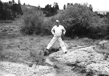 |
| Trail Creek, one of the sources of the Missouri, about 2 miles east of Lemhi Pass. Lewis said, "....McNeal had exultingly stood with a foot on each side of this rivulet and thanked his god that he had lived to bestride the mighty & heretofore deemed endless Missouri." Above, Roy Appleman National Park Service, straddles the same stream at approximately the same place. (National Park Service.) |
At a point 2 miles more to the westward, the four men arrived at what they considered to be the source of the Missouri—in Lewis' words "the most distant fountain of the waters of the Mighty Missouri in surch of which we have spent so many toilsome days and wristless nights . . . one of those great objects on which my mind has been unalterably fixed for many years." [107] A short ways farther, they strode onto the Continental Divide—Lemhi Pass—the first Americans to reach it. Before them lay the land of the Columbia drainage, whose distant manifestation were immense ranges of snow-covered mountains. The journey up the Missouri had ended, and the portage to the Columbia system was soon to begin.
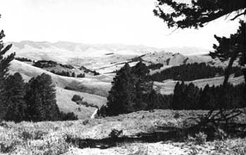 |
| Eastern approach to Lemhi Pass, looking eastward from the Continental Divide. (Bureau of Outdoor Recreation (Jonathan Blair, 1964).) |
Descending the Beaverhead Mountains from Lemhi Pass along the Indian trail about three-quarters of a mile and at the same time moving from present Montana into Idaho, the party found a bold-running creek, one of the headwaters of the Lemhi River. From it, Lewis first tasted the water of the great Columbia system. Camp was made some miles down the mountain slope leading to the Lemhi Valley.
The next morning, August 13, the march continued along the trail. Near the valley floor, two women, a man, and some dogs came into view about a mile away. For a time, they watched the approaching white men. When the natives were about half a mile away, Lewis moved on ahead alone, carrying the flag. He cried out "tab-ba-bone" and walked toward them, but they disappeared when he came within 100 yards.
 |
http://www.cr.nps.gov/history/online_books/lewisandclark/intro40.htm
Last Updated: 22-Feb-2004