Directions and Transportation

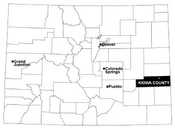
A map of the state of Colorado with Kiowa County highlighted in the southeastern portion of the state
Map of Colorado with Kiowa County highlighted.

NPS Photo

Sand Creek Massacre National Historic Site is located within Kiowa County in rural southeastern Colorado, 23 miles to the northeast of Eads, Colorado.

Public Transportation

Currently there is no public transportation available between Sand Creek Massacre NHS and the surrounding communities.

Road Conditions

Sand Creek Massacre National Historic Site is reached by traveling a minimum of 8 miles on dirt roads. Because of this, when there are significant amounts of rain or snow, it is recommended that you call the site at (719)-438-5916 to ask the on-duty Ranger for further information regarding road conditions.

Caution for Large Vehicles and Motorcycles: A minimum of eight (8) miles of dirt/sand roads lead to the site.

Directions to the Massacre Site from Eads

  1. When leaving downtown Eads, travel south on Maine St. for 1/10 mile.
  2. Turn left onto Hwy. 287 South/96 East for 2.7 miles.
  3. Turn left onto Hwy. 96 East for 11 miles, continue through the town of Chivington.
  4. 1/2 mile after Chivington, turn left, North, onto Chief White Antelope Way, County Road 54, for 7 miles.
  5. Turn right (East), onto County Road W for 1.3 miles.
  6. The entrance to the Massacre Site is on your left. Parking is available across from the orientation area.

Last updated: March 2, 2025

Park footer

Contact Info

Mailing Address:

1301 Maine Street
P.O. Box 249

Eads, CO 81036-0249

Phone:

719 438-5916

Contact Us