Maps

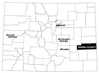
A map of the state of Colorado with Kiowa County highlighted in the southeastern portion of the state
Map of Colorado with Kiowa County highlighted.

NPS Photo

Sand Creek Massacre National Historic Site is located in southeastern Colorado in Kiowa County. The Visitor Center is located in the community of the Eads, and the massacre site itself is a half hour drive to the northeast.
 
Map showing roads from Eads to the Massacre site
Map showing the driving route between the Visitor Center in Eads, Colorado, and the Massacre site to the northeast.

NPS Photo

Directions to the Massacre Site from Eads

  1. After leaving the Visitor Center in Eads, travel south on Maine St. for 1/10 mile.
  2. Turn left onto Hwy. 287 South/96 East for 2.7 miles.
  3. Turn left onto Hwy. 96 East for 11 miles, continue through the town of Chivington.
  4. 1/2 mile after Chivington, turn left, North, onto Chief White Antelope Way, County Road 54, for 7 miles.
  5. Turn right (East), onto County Road W for 1.3 miles.
  6. The entrance to the Massacre Site is on your left. Parking is available across from the picnic area.

Directions to Eads from the Massacre Site

  1. Leaving the Massacre site, turn right, West, on Country Road W for 1.3 miles.
  2. Turn left (South), onto Chief White Antelope Way, County Road 54 for 7 miles.
  3. Turn right (West), onto Hwy. 96 West for 12 miles.
  4. Merge onto Hwy. 287 N/96 West for 2.7 miles.
  5. Turn right (North), onto Maine Street in the town of Eads for 1/10 mile.
  6. The Visitor Center is located at the corner of Maine St. and 13th St. across from the movie theater.
 

Last updated: November 13, 2023

Park footer

Contact Info

Mailing Address:

1301 Maine Street
P.O. Box 249

Eads, CO 81036-0249

Phone:

719 438-5916

Contact Us