
USGS photo by Ben Pauk.
Introduction
The United States is one of the most volcanically active countries on Earth, containing about 10% of the planet’s potentially active volcanoes. At least 32 of these volcanoes are either entirely or partially within a national park unit. National parks contain volcanoes because they create beautiful landscapes, and they remind us of the awesome power of the geologic forces that shape our planet. They are also an important part of our nation’s geoheritage, and incorporating them in parks ensures the preservation of these volcanic landscapes for enjoyment, education, and inspiration of this and future generations.
Although the National Park Service is responsible for managing all national parks and most national monuments, the US Geological Survey, the nation’s premiere natural science agency, has been mandated by Congress to monitor active and potentially active volcanoes.
Volcano Observatories
The US Geological Survey maintains five volcano observatories:
-
Hawaiian Volcano Observatory
-
Cascades Volcano Observatory
-
California Volcano Observatory
-
Yellowstone Volcano Observatory
-
Alaska Volcano Observatory
These observatories monitor 161 volcanoes in 12 states and two US territories.
U.S. Volcanoes and Volcanic Threats

Public Domain.
Volcanoes in National Park Sites
| National Park Site | Volcano(es) partly or wholly within a park |
| Mount Rainier National Park, Washington | Mount Rainier |
| Crater Lake National Park, Oregon | Crater Lake |
| Lava Beds National Monument, California | Medicine Lake |
| Lassen Volcanic National Park, California | Lassen Volcanic Center |
| Devils Postpile National Monument, California | Mammoth Mountain |
| Death Valley National Park, California | Ubehebe Crater |
| Sunset Crater National Monument, Arizona | San Francisco Volcanic Field |
| Valles Caldera National Preserve, New Mexico | Valles Caldera |
| Yellowstone National Park, Wyoming, Montana, Idaho | Yellowstone Caldera |
| Craters of the Moon National Monument, Idaho | Craters of the Moon |
| Lake Clark National Park, Alaska | Illiamna Volcano, Redoubt Volcano |
| Katmai National Park, Alaska | Mount Martin, Mount Mageik, Trident Volcano, Novarupta, Mount Griggs, Mount Katmai, Snowy Mountain, Mount Denison, Mount Steller, Kukak Volcano, Kaguyak Crater, Fourpeaked Mountain, Mount Douglas |
| Aniakchak National Monument, Alaska | Aniakchak Crater |
| Hawai’i Volcanoes National Park, Hawai’i | Kīlauea, Mauna Loa |
| Haleakalā National Park, Hawai’i | Haleakalā |
| El Malpais National Monument, New Mexico | Zuni-Bandera volcanic field |
| Wrangell-St. Elias National Park, Alaska | Mount Wrangell, Mount Churchill |
| Mount St. Helens National Volcanic Monument, Washington (managed by U.S. Forest Service) | Mount St. Helens |
| Newberry National Volcanic Monument, Oregon (managed by U.S. Forest Service) | Newberry Volcano |
Volcanic Threat Assessment

The US Geologic Survey’s Volcanic Threat Assessment evaluated volcanoes that have erupted during the Holocene (the last 11,700 years), which are considered to be potentially active. The assessment determined the potential geohazards of each volcano plus the risk each poses to people, buildings, and infrastructure that may be harmed by these volcanic hazards.
The threat assessment is this intersection between exposure (risk) and volcanic hazards:
-
Volcanic Hazards: Dangerous natural phenomena produced by a volcano.
-
Exposure: People and property at risk to volcanic phenomena.
- Volcanic Threat: Qualitative risk of a volcano to people and property.
Rankings of volcanic threat are assigned one of five categories:
-
Very High Threat
-
High Threat
-
Moderate
-
Low
-
Very Low

People and infrastructure are an integral part of the threat assessment. For example, a volcano that presents many volcanic hazards but is in a remote area where there is little exposure of people or infrastructure to those hazards may be ranked lower in the threat assessment than a similar volcano with more exposure.
Related Links
Hazards Associated with Volcanoes
")
University of Washington, Public domain, via Wikimedia Commons.
Some volcanic hazards are only present during periods of active eruption or restlessness, but others are not associated with eruptions and can occur at any time.
Volcanoes are diverse in terms in their eruption style(s), size, shape, and what hazards they may present. Most volcanoes fall into one of the three major types: cinder cone, composite volcano, and shield volcano.
Learn More
Each volcano type has characteristic styles of eruptions that may produce lava flows, eruption columns of ash and tephra, and other phenomena such as lahars or pyroclastic flows. Eruptions themselves may be hazardous and are often preceded by earthquakes. Gases emitted during volcanic eruptions and at other times can also create volcanic hazards including acid rain and vog (volcanic smog).
Some volcanic hazards are not limited to periods of eruptions. Volcanic mountains are often unstable and are subject to landslides at any time. Hydrothermal areas, fumaroles, and some gas emissions also present hazards even while a volcano is otherwise quiet.
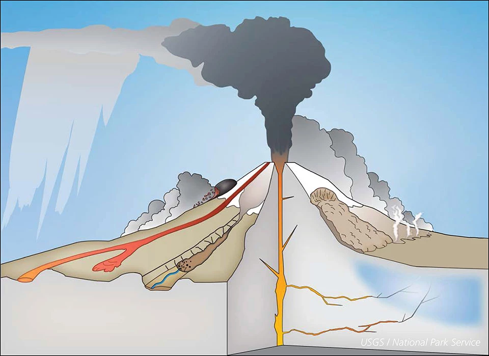
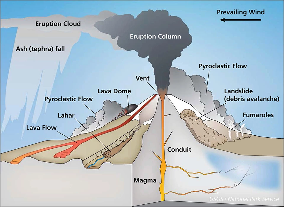
Left image
Schematic diagram of a composite volcano.
Credit: Modified from USGS illustration.
Right image
Diagram with feature labels.
Credit: Modified from USGS illustration.
Eruptions, Explosions, and Blasts
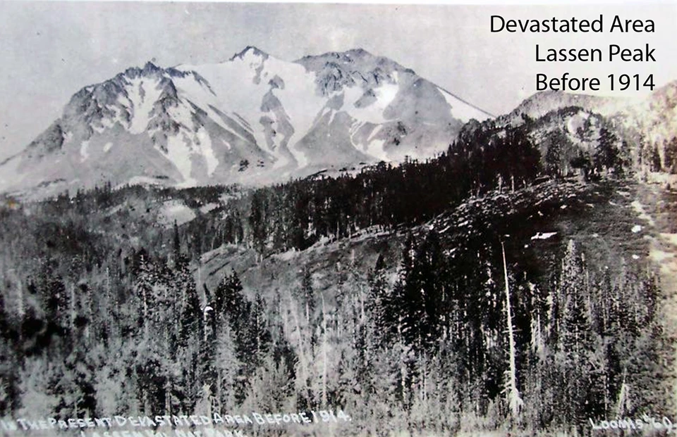
Left image
The view from the Devastated Area in 1914, before the May 1915 cataclysmic eruptions.
Credit: USGS photo.
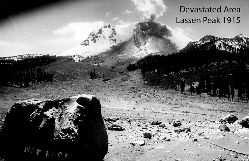
Right image
View showing the devastation of the May 19 eruption, including area of tree blow-downs, debris avalanche and lahar. The rock labeled “Hot rock” was still warm to the touch when the photograph was taken on May 22.
Credit: USGS photo.
Volcanic eruptions are the expulsion of gases, rock fragments, and/or molten lava from within the Earth through a vent onto the Earth’s surface or into the atmosphere.
Eruptions may be effusive or explosive. Effusive eruptions produce lava flows and they have relatively few volcanic hazards associated with them, although large eruptions may include great quantities of volcanic gases.
Explosive eruptions may include violent expulsions and blasts that can devastate regions for many miles surrounding the volcanic vent.
For example, the 1980 eruption of Mount St. Helens, although relatively modest on the scale of potential volcanic events obliterated forests over 230 square miles (600 km2), killed 57 people, and caused more than $1 billion in damages.
Learn More


Earthquakes
The movement of magma and gases underneath a volcano can cause volcanic earthquakes. Magma in motion may cause a volcanic tremor, which is a long-lasting release of seismic energy that may be rhythmic or harmonic. Other types of shallow earthquakes may result from rock fracturing in response to magma and fluid movements. These earthquakes are often precursors to eruptions.Lava Flows
Lava flows result from outpourings of molten rock from a vent onto Earth's surface during an effusive volcanic eruption. Depending on the composition of the lava and other factors, lava flows may travel many miles from the vent or form short stubby flows or domes.
Lava flows almost always bury everything in their path, including vegetation and buildings, and often ignite fires due to their high temperatures
Lava flows almost always bury everything in their path, including vegetation and buildings, and often ignite fires due to their high temperatures
Learn More
Ash and Tephra

Ash and tephra clouds pose great hazards to aircraft and are a significant geohazard. Ash clouds can envelop neighboring communities causing the skies to darken for days following an eruption.
Ash-fall deposits can cause significant damage to buildings and other infrastructure, agriculture, and human health. Volcanic ash particles are highly abrasive and present hazards to the health of people, livestock, and wildlife.
Related Links
Lahars

Lahars are volcanic mudflows that consist of a mixture of water, volcanic ash and tephra, and rock fragments that can flow like wet concrete. They are one of the most destructive of all volcanic phenomena. They can occur during eruptions or at other times due to melting snow or flood events. They also can travel many miles from volcanoes. They move down river valleys, which is also where people tend to live, thereby creating many volcanic hazards.
Learn More
Pyroclastic Flows

Pyroclastic flows are ground-hugging flows of hot volcanic gases and particles (pumice, ash, and blocks) that rapidly travel down the slopes of a volcano at speeds of more than 200 miles per hour (320 km per hour). They are generated during some explosive eruptions, particularly on compositive volcanoes. They destroy nearly everything in their path and are almost always deadly to humans and animals.
Related Links
Volcanic Gases
Volcanic gases including water vapor, carbon dioxide (CO2) sulfur dioxide (SO2), hydrogen sulfide (H2S), and others are emitted during eruptions, and sometimes continuously from fumaroles. Except for water vapor, these gases present geohazards because they can be toxic or even lethal.Gases erupted from volcanoes have the potential to impact climate and weather. Fine sulfate aerosols formed by volcanic gases may remain in the stratosphere for months to a few years reflect solar radiation back into space, causing global cooling. On the other hand, carbon dioxide is a greenhouse gas and can cause global warming.
Learn More
Volcanic Monitoring Techniques

The goal of volcanic monitoring techniques is to provide real-time information to protect life and property in the case of volcanic activity or unrest. Volcanic monitoring aims to detect and measure signals caused by magma movement beneath a volcano, which happens prior to eruption, sometimes over days, weeks, or in some cases, much longer periods.
Rising magma typically will:
-
Trigger swarms of earthquakes and other types of seismic events;
-
Cause deformation (swelling or subsidence) of a volcano’s summit or flanks;
-
Release of volcanic gases from the ground and from vents.
By monitoring changes in the state of a volcano, volcanologists look for signs that may indicate that it might erupt. Each volcano has its own unique characteristics in terms of the dynamics of its magma chambers, magma compositions, and other factors. Therefore, it is important that each potentially active volcano be monitored so scientists can understand its history and features. Some volcanoes erupt frequently and others less so; regardless no volcano erupts at exact intervals.
By studying a volcano’s past eruptions, and how they vary in terms of their style, frequency, intensity, and magnitude, as well as continually monitoring current conditions, volcanologists can make an assessment of its hazards and threats.
Earthquake Activity and Ground Vibrations
Volcanologists monitor volcanoes for seismic activity as magma movement frequently causes earthquakes and is a significant precursor to eruption. Scientists use networks of seismometers located in and around volcanoes that are considered potentially active as a key part of volcano monitoring.
Seismic monitoring is also used to detect ground vibration caused by lahars, which is critical since lahars may occur at any time (e.g., not only during eruption).

Featured Videos
IRIS is a world leader in advancing discovery, research, and education in seismology to understand our planet and to benefit society, see IRIS-Teaching Resources.
Ground Deformation
Ground deformation is often a precursor to eruptions as magma that is injected into shallow magma chambers can cause parts of a volcano to bulge and sometimes even inflate like a balloon. Volcanologists use tiltmeters and high-precision GPS stations installed on various locations of a volcano, in addition to more traditional surveying techniques like and triangulation and electronic distance measurement.They also use remote-sensing techniques to take a big picture look at the surface of a volcano to see how it may be changing.
Learn More

Featured Videos
-
IRIS—Volcano Monitoring: Measuring Deformation and Tilt with GPS
-
[Similar on youtube]—Volcano Monitoring with Tiltmeters and GPS (Educational)
Gas Emission
Changes in gas emissions from volcanoes may also be a precursor to eruption. As magma rises and approaches the surface, the decreasing pressure causes the magma to release gases, which may be emitted at the surface. Volcanologists look for changes in gas emissions from a volcano to see if there are any signals of an impending eruption. Gas is monitored using ground-based sensors and airplanes, as well as with remote sensors.

Featured Video
Related Links
Remote Sensing
Remote sensing techniques provide volcanologists with many monitoring tools. Thermal imaging cameras provide information on temperature, and cameras and webcams provide nearly continuous information about the eruption status of a volcano, including ones in remote areas.
For example, multiple cameras and webcams provide information on Kīlauea and Mauna Loa in Hawai’i Volcanoes National Park, and on Redoubt and Iliamna in Lake Clark National Park and Preserve in Alaska.
Satellites provide important information about whether volcanoes are changing shape due to magma movement within them and as well as the location of any ash clouds that may have been formed by an explosive eruption of a composite volcano. InSAR uses satellite data to detect if a volcano has inflated or deflated because of magma movement.
Other tools include making digital elevation models to assess changes in the topography of a volcano.
Related Links

Featured Video
Related Links
-
USGS—InSAR Satellite-based technique captures overall deformation "picture"
-
USGS—Digital Elevation Models (DEMs) map changes to a volcano's topography
Conclusion
Like other natural hazards, volcanic hazards can pose serious threats to people and communities. Monitoring volcanoes and understanding volcanic hazards allows scientists to warn communities when danger is imminent, ultimately protecting human health, safety, and well-being. To learn more about what volcanoes in the U.S. are actively monitored and to see the data collected on them, visit the USGS USGS Volcano Hazards Program website.
Related Links
Webpage Credits and References
Monitoring Volcanoes—Student Page (2024)
Text by Allyson C. Mathis (geologist / science writer). Contributors: Lindsay Mossa (AGI). Web development: Jim Wood (NPS, GRD).
Produced under a Cooperative Agreement for earth science education between the National Park Service's Geologic Resources Division and the American Geosciences Institute.
Citing pages from NPS websites:
National Park Service (Year, Month date—from "last update" at the bottom of the webpage). Page title—from the top of the webpage, but in sentence-case and italics. NPS.GOV. Https://www.nps.gov/subjects/volcanoes/...—Use the full address of the webpage you're citing with no puncuation after the address
References
Last updated: September 27, 2024