Last updated: April 6, 2023
Thing to Do
Take the Scenic Route on the Potomac Heritage Trail
Explore the Potomac Heritage Trail
Details
Duration
1-8 Hours
Activity
Self-Guided Tours - Walking
Hiking opportunities are extensive and one of the best ways to experience the beauty, history and culture of the Trail network.
Paddling the Potomac and Youghiogheny rivers, as well as their tributaries, often provides intimate connections with natural areas and unique perspectives on urban environments. Explore those water trails with these helpful pages, developed in 2012 with the assistance of the River Management Society.
Age(s)
The Potomac Heritage Trail network includes many activities for children, youth and families.
Pets Allowed
Yes
Leashed pets are welcome on all park trails, parking lots and picnic areas. There are no off-leash areas on the trail. Owners must have physical control of the animal, using a six foot leash, at all times. Electronic or 'shock' collars do not count as a leash. With the exception of service dogs, pets are not permitted in the visitor center, or on ranger-led programs.
Ticks are common throughout the Trail and pose risk for tick-borne illnesses including Lyme Disease. Take precautions to prevent tick bites and do frequent tick checks of yourself and children and pets with you.
Activity Fee
Yes
Some facilities within the Trail corridor charge a fee (e.g., some parks, historic sites, etc.) and some require reservations (e.g., shelters along the Laurel Highlands Hiking Trail). Please check with a Trail management partner for current information.
Location
Potomac Heritage National Scenic Trail
The Trail network consists of many segments and includes portions of Maryland, Pennsylvania, Virginia, and the District of Columbia. With numerous trailheads dispersed throughout various regions, accessing the Trail by many types of transportation is possible.
Directions to trailheads and other facilities associated with segments of the PHT network can be found on various maps and on the web sites of our Trail management partners.
- A KMZ file is available for download and provides a view of the primary Trail segments through Google Earth.
Reservations
No
Season
Year Round
The Trail is open year-round, weather permitting.
Please refer to our Operating Hours & Seasons for more information.
Time of Day
Day
Accessibility Information
The National Park Service welcomes people with disabilities. For information about specific facilities, programs and services please contact the site you would like to visit on the trail management partners' page.
You may wish to learn about the America the Beautiful National Parks and Federal Recreational Lands Access Pass.

NPS
Hike, bike or paddle your way through this historic trail!
Check out these places along your way:
PHT users can experience natural beauty or cultural significance at each of these scenic stops, worthy of conservation! Click on the title of the region for a drop-down list.Laurel Highlands Hiking Trail Scenic Views
Check out these scenic views along the LHHT! Is there a viewpoint missing? Can you provide us with missing data, such as coordinates? Let us know via pohesocialmedia@nps.gov.
| Name of Scenic View | Location (approx.) | Latitude | Longitude | Center Bearing |
|---|---|---|---|---|
| LHHT viewpoint 1 (overlooking the Youghiogheny) | Mile 2.5 | N/A | N/A | N/A |
| LHHT viewpoint 2 (overlooking the Youghiogheny) | Mile 4 | N/A | N/A | N/A |
| LHHT viewpoint 3 | Mile 8 | N/A | N/A | N/A |
| LHHT viewpoint 4 | Mile 9 | N/A | N/A | N/A |
| LHHT viewpoint 5 | Mile 21.5 | N/A | N/A | N/A |
| LHHT viewpoint 6 | Mile 29 | N/A | N/A | N/A |
| LHHT viewpoint 7 | Mile 30 (near PA Route 31 trailhead) | N/A | N/A | N/A |
| LHHT viewpoint 8 | Mile 38.5 (near PA Turnpike shelter area) | N/A | N/A | N/A |
| LHHT viewpoint 9 | Mile 61.0 | N/A | N/A | N/A |
| LHHT viewpoint 10 | Mile 62.5 | N/A | N/A | N/A |
| LHHT viewpoints overlooking Conemaugh Gorge | Mile 66.5-69.5 | N/A | N/A | N/A |
Note: some of these coordinates are approximate; please use caution and observe all regulations.
Great Allegheny Passage Scenic Views
Check out these scenic views along the GAP Trail! Is there a scenic view missing? Can you provide us with missing data, such as coordinates? Let us know at pohesocialmedia@nps.gov
| Name of Scenic View | Location (approx.) | Latitude | Longitude | Central Bearing |
|---|---|---|---|---|
| Bridges over the Youghiogheny River | Ohiopyle, PA | N/A | N/A; | N/A |
| Turkeyfoot Overlook | Mile 62, Confluence PA | N/A | N/A | N/A |
| Salisbury Viaduct | Mile 33.5, near Meyersdale, PA | 39.8341561 | -79.0477227 | 360° |
| Big Savage View | Mile 22, SE entrance of Big Savage Tunnel | 39.7454349 | -78.8965415,14 | South East |
There is also a scenic view along the Eastern Continental Divide Loop at High Rocks along the Meadow Mountain Trail looking toward Big Savage Mountain.
Note: some of these coordinates are approximate, and caution, and observance to all rules and regulations should be followed while pursuing these viewpoints.
Chesapeake and Ohio Canal National Historical Park Scenic Views
Check out these scenic views along the C&O Canal! Is there a scenic view missing? Can you provide us with missing data, such as coordinates? Let us know at pohesocialmedia@nps.gov
| Name of Scenic View | Location (approx.) | Latitude | Longitude | Central Bearing * |
|---|---|---|---|---|
| Canal Plaza Place (terminus) | Mile 184.5 Cumberland, MD | 39.649658 | 78.7639392,260 | 360° |
| Paw Paw Bends View | Mile 156-157, Lat/Long is for SW trailhead | 39.550448 | 78.463064 | South |
| Paw Paw Western Maryland Railroad Bridge View | Mile 156 (on banks of Potomac) | 39.545329 | 78.461149 | Northwest |
| View of Maryland Heights;"The Point" | Mile 60.8 Harpers Ferry,WV | 39.322977 | -77.728573 | 360° |
| Jefferson Rock | Harpers Ferry, WV | 39.3223604 | -77.73342 | South-south-west |
| Big Slackwater (boat ramp) | Mile 85,Sharpsburg, MD | 39.5007252 | -77.8473884 | Southwest |
| Point of Rocks | Mile 48.2 | N/A | N/A | N/A |
| Monocacy Aqueduct | Mile 42 | 39.223950 | -77.452192 | 360° |
| Whites Ferry | Mile 35.5, Dickerson MD | 39.154645 | -77.519681 | West |
| Great Falls Overlook | Great Falls, Maryland | 38.997339 | -77.2513691 | West, Northwest |
| Mile Marker 0 SE of Thompson Boat Center | Mile 0, at mouth of Rock Creek | 38.899927 | -77.057562 | Southwest |
Note: some of these coordinates are approximate, and caution, and observance to all rules and regulations should be followed while pursuing these viewpoints.
Northern Virginia and DC Scenic Views
Check out these scenic views along the Northern Viriginia and DC region! Is there a scenic view missing? Can you provide us with missing data, such as coordinates? Let us know at pohesocialmedia@nps.gov
| Name of Scenic View | Location (approx.) | Latitude | Longitude | Central Bearing |
|---|---|---|---|---|
| Great Falls View | River Trail in Great Falls Park, McLean, Virginia | 38.9963876 | -77.2540841 | West |
| Ball's Bluff National Cemetery (near Turtle Run fork) | Leesburg, Catoctin, VA | N/A | N/A | West |
| Views of National Monuments over the Potomac | Mount Vernon Trail, MD, VA, DC | N/A | N/A | N/A |
| Arlington House View of Fort Circle | Arlington House, Fort Myer, VA | 38.8782284 | 77.0739277 | 360° |
| Woodrow Wilson Memorial Bridge | Washington DC (Lat/Long is Approx) | 38.792905 | -77.033521 | 360° |
| Portico Potomac View | George Washington's Mount Vernon, VA | 38.707885 | -77.0862793 | Southeast |
| Deephole Point, Occoquan Bay National Wildlife Refuge | Woodbridge, VA | 38.637914 | -77.228275 | Southeast |
| Veteran's Memorial Park View | Woodbridge, VA | 38.644171 | -77.247338 | West |
| Winter View at Rippon Lodge | Woodbridge, VA | N/A | N/A | N/A |
| Chatham Manor | Fredericksburg, VA | N/A | N/A | West |
Note: some of these coordinates are approximate, and caution, and observance to all rules and regulations should be followed while pursuing these viewpoints.
Southern Maryland Scenic Views
Check out these scenic views in the Southern Maryland and DC area! Is there a scenic view missing? Can you provide us with missing data, such as coordinates? Let us know at pohesocialmedia@nps.gov
| Name of Scenic View | Location (approx.) | Latitude | Longitude | Central Bearing |
|---|---|---|---|---|
| Piscataway Park Lookout towards Mount Vernon | Accoceek Foundation, MD | 38.695858 | -77.065961 | Northwest |
| Chapel Point Overlook | Chapel Point Cemetery, MD | N/A | N/A | Northwest |
| Port Tobacco Creek Views | Port Tobacco Historic District, MD | N/A | N/A | 360° |
| McIntosh Run and Breton Bay View | Leonardtown Wharf Park, MD | 38.286201 | -76.638799 | Southwest |
| Chancellor's Point | Historic St. Mary's City, MD | 38.169412 | -76.440839 | West |
Note: some of these coordinates are approximate, and caution, and observance to all rules and regulations should be followed while pursuing these viewpoints.
Northern Neck of Virginia Scenic Views
Check out these scenic views in the Northern Neck of Virginia! Is there a scenic view missing? Can you provide us with missing data, such as coordinates? Let us know at pohesocialmedia@nps.gov
| Name of Scenic View | Location (approx.) | Latitude | Longitude | Central Bearing |
|---|---|---|---|---|
| Caledon State Park Shoreline | King George, VA | 38.348622 | -77.157668 | Northwest |
| Horsehead Cliffs | Westmoreland State Park, Montross, VA | 38.172525 | -76.875328 | Northeast |
| George Washington Birthplace of Popes Creek | Colonial Beach, VA | 38.185881 | -76.916267 | Northeast |
| Stratford Hall View | Stratford, VA | 38.1519269 | -76.841643 | East |
| Kinsale Historic Distric Harbor | Kinsale, VA | 38.0302518 | -76.5769272 | Northeast |
| Sunnybank Ferry North Dock | Heathsville, VA | 37.890760 | -76.269722 | Northwest |
| Smiths Point at Chesapeake Bay | Smiths Point, VA | N/A | N/A | 360° |
| Reedville Historic District | Reedville, VA | N/A | N/A | 360° |
Note: some of these coordinates are approximate, and caution, and observance to all rules and regulations should be followed while pursuing these viewpoints.
Send us your suggestions!
Do you have a favorite viewpoint or viewshed you would like to see preserved along the PHT network? We would appreciate your comments, feedback and photos. Contact us at pohesocialmedia@nps.gov or our Facebook page and tell us what you feel are the most important viewpoints and/or viewsheds throughout the PHT network. Follow us and tag us in pictures of your favorite viewsheds on Instagram at @potomacheritagetrail.
Scenic Views
-
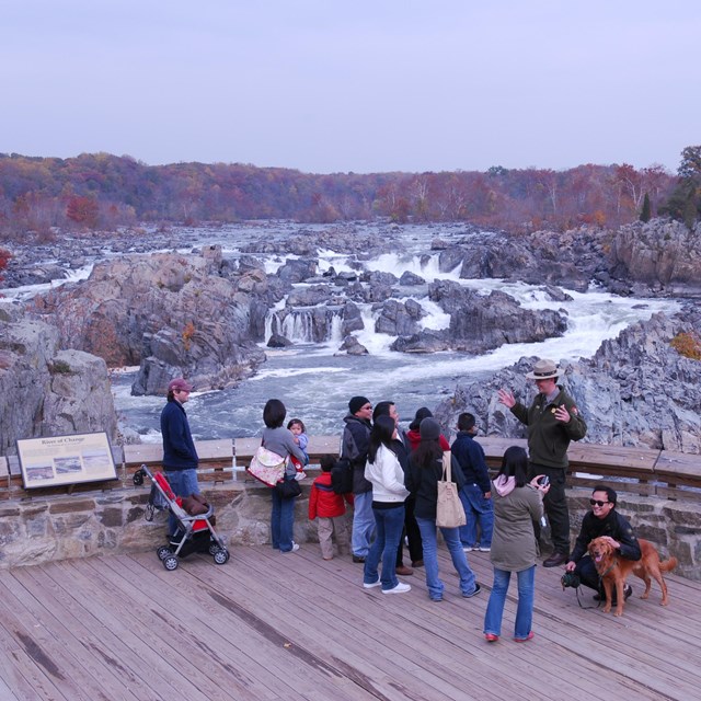 Great Falls Overlooks
Visitors view the falls from the Virginia side of the Potomac River at Great Falls Park.
-
 Jefferson Rock, Harpers Ferry NHP
Jefferson Rock is a popular destination in Harpers Ferry. It is situated along the Appalachian Trail between the Lower Town and Camp Hill.
-
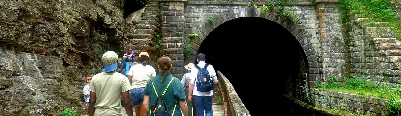
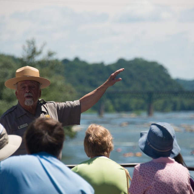
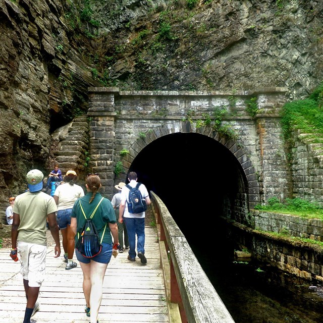 Potomac Heritage Trail
There are many places to access the Potomac Heritage Trail, including many connector trails from county parks.
-
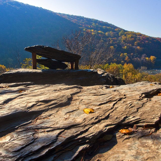
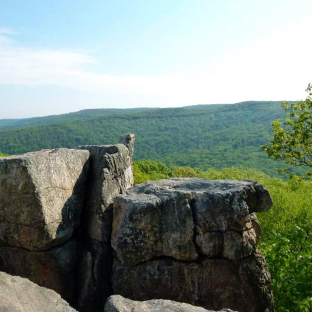 Chimney Rock, Catoctin Mountain Park
Chimney Rock is at about 1,400 feet in elevation and looks out to the east over the piedmont region.
-
 The Point at Harpers Ferry
Gaze upon the magnificent sight of this water gap in the Blue Ridge Mountains.
-
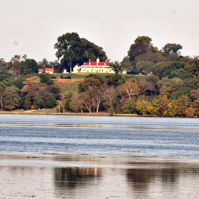 View Mount Vernon
As a scenic easement meant to preserve the view from Mt. Vernon, Piscataway Park is a testament to the rich history of the Potomac River.